Team A Report: Marking The Waste Isolation Pilot Plant For 10,000 Years
@TODO
Prepared by:
Dieter G. Ast
Michael Brill
Ward Goodenough
Maureen Kaplan
Frederick Newmeyer
Woodruff Sullivan
[“TEAM A”]
April 1992
Table of Contents
1 General Considerations
1.1 Background information on marking the WIPP site
The Waste Isolation Pilot Plant (WIPP) is a research and development facility for the disposal of defense wastes. Defense wastes are primarily transuranic wastes (TRU). TRU is defined as materials contaminated with isotopes with an atomic number greater than 92, a half-life greater than 20 years, and a concentration greater than 100 nanocuries per gram. The existence of such a site was mandated by Public Law 96-164 (Department of Energy National Security and Military Applications of Nuclear Energy Authorization Act of 1980).
The WIPP site is located in southeastern New Mexico, about 25 miles east of Carlsbad. The site currently consists of a 16 square-mile area (the land withdrawal area) and a fenced area that is approximately 1.5 miles on a side. Within the secured boundary lie the waste handling building and subsidiary offices. The underground waste disposal panels and rooms are designed to lie within the secured boundary. These panels and rooms are designed to occupy an area that is 2,064 feet by 2,545 feet at a depth of2,157 feet. There is an overlying aquifer, but the water is not potable. The site is located in an arid region (about 12 inches of rainfall per year) that supports cattle grazing but not dry farming. The arid landscape is undulating in the southeastern part of the site with both stabilized and mobile sand dunes.
WIPP is regulated by an EPA standard set in 1985 [Ref. 1-1].
There are several important features of the Standard:
- It requires a marking system at the site; i.e., it states that "Disposal sites shall be designated by the most permanent markers, records, and other passive institutional controls practicable to indicate the dangers of the wastes and their location" (40 CFR 191.14(c)).
- The performance assessment for the disposal facility must be probabilistically-based. That is, not only must the consequences of a given scenario be calculated, the likelihood of that scenario must be estimated (40 CFR 191.13).
- The time period of interest is 10,000 years (40 CFR 191.13 (a)).
- Active institutional controls are considered effective for no more than 100 years (40 CFR 191.14(a)).
In other words, there is a legal requirement to mark the site. It is this requirement that led Sandia National Laboratories to convene what are known as the Futures panel and the Markers panel. The first group examined the possible "futures" over the next 10,000 years and considered a wide range of conceivable cultures, population sizes, and technical developments. The role of the Markers panel is to develop design characteristics for marking systems for the WIPP site and to judge their effectiveness against the intrusion scenarios developed by the Futures panel. The charge to the Markers panel will be discussed in more detail in Section 1.2.
The Sandia work is the second major effort to consider the long-term marking of nuclear waste disposal sites. The U.S. Department of Energy convened the Human Interference Task Force (HITF) in 1980 [Ref. 1-2].
The value of that work lies in establishing the credibility and feasibility of the effort to design long-term marking systems for nuclear waste disposal sites. The Sandia approach differs from the HITF approach in two important features:
- The Sandia approach divided the experts into two teams. The reports, then, reflect interdisciplinary team efforts rather than the focus of individual specialties. It should not be surprising that some designs presented in this report are dramatically different from those presented a decade ago.
- The Sandia approach involves the elicitation of subjective probabilities for the likelihood of deterring human interference with the site. This part of the effort is required to evaluate whether WIPP meets the probabilistic basis of the EPA regulation.
1.2 Charge to the expert panel
The Marking System Teams were given a seven-fold charge:
- Recommend markers that should be used to mark the WIPP disposal site.
- Provide physical descriptions of the markers, including size, location, shape, and materials.
- Provide the message on the markers and the method of conveying the messages.
For each major mode of intrusion identified by the Futures panel:
- Estimate the likelihood that each marker has survived (i.e., it is recognizable and the message is apparent).
- Estimate the likelihood that the potential intruder will recognize and correctly interpret the message, given that the marker has survived.
- Estimate the likelihood that a potential intruder will take appropriate action to avoid intrusion given that the marker has survived and that the potential intruder has recognized and correctly interpreted the message.
For the system of markers:
- Re-estimate the likelihood that the system persists, the message is correctly interpreted, and intrusion is deterred.
The focus of this report is the first three items, which will form a basis for probability estimates from each individual member of the team. Finally, the Markers panel was instructed not to consider cost when developing marking system designs.
The following working assumptions have governed the panel's view of the possible scenarios relating to its charge:
- Climate will vary from that of a desert or near desert to that of good grassland. At best, water will be a scarce resource. Probability of significant change in availability of water over the next 10,000 years is very low.
- The region will be sparsely inhabited under the best of conditions, most likely by keepers of livestock, once natural gas has been taken out of the area over the next few hundred years.
- A tradition directly descended from one or another of the modern technologically, scientifically, and scholarly developed societies will continue through the next 10,000 years, barring catastrophic developments on a scale that makes that impossible.
- Continuity of human existence guarantees that whatever languages are spoken over the next 10,000 years, they will be lineal descendants of one or more languages spoken now, most probably those most widely spoken and written now.
- Because literacy has not ceased to exist since it was first developed some 6,000 years ago, it will not cease to exist over the next 10,000 years, nor the scientific and scholarly traditions based on it, again barring catastrophic developments on a scale that makes that impossible.
In light of these assumptions, the following scenarios have been considered in relation to the problem of marking the WIPP site:
- Human existence has been reduced to what can be supported by a metal-using technology similar to that of early medieval Europe -- use of iron tools, limited literacy, technology capable of deep intrusion at the site if there was extraordinarily high incentive for doing so. Local inhabitants of the site area are most likely to be livestock keepers and small-scale river-bottom farmers. The probability of an intrusion is relatively low. There is little need for a marking system. A marking system that is awesome and scary, as suggested in this report, may invite its being used for religious purposes or as a place of assembly among groups in the area, but is unlikely to invite deep intrusion, especially considering the effort it would require.
- Human existence has continued with regional ups and downs over the world at the present level of technological sophistication, at least, if not a higher one. But the area of the WIPP site has been a marginal one for human habitation and exploitation because of the cycles of climatic changes between desert and grassland. People encountering the site following a period of desertification are likely to be relatively unsophisticated themselves, livestock keepers or resource prospectors. If the site is marked by a massive, awesome, and rather scary marking system, word of it is more likely to be disseminated so that it will come to the notice of officials and scholars and scientists of the time. Once they have learned of it, its massive scale will draw scholars and scientists to study it, decipher the messages inscribed there, and thus become acquainted with the nature of the site and what is buried there. In the absence of such study and reacquaintance with what is there, the likelihood of inadvertent intrusion is greater.
- Human existence went through a period of global catastrophe in which it was reduced to illiteracy and something bordering on a Stone Age level of technology, and then redeveloped new patterns of technological sophistication, new literacy, and new science. The probability that people would then be able to decipher and understand the true meaning of the messages inscribed there is low, unless the inscriptions provide a key to their interpretation. By having the same messages in different languages arranged in a way that shows them to be parallel messages, the site design can provide the equivalent of the Rosetta Stone that will increase the probability of successful decipherment.
It is to the last two scenarios above that our team has considered a marking system to be most relevant. With these scenarios in mind, we decided on a systems approach to marking with
- Several components within a given design,
- Multiple items within each component, and
- Two-way indexing linking different levels of information and system marking components.
With this approach, we can afford to lose items within a given component without seriously compromising the effectiveness of the entire design. (For example, about one-third of the stones of Stonehenge are missing, yet the entire design can be reconstructed without major controversy.) Under these conditions, it is the probability estimate for the entire system that is relevant, not those for individual markers.
Second, a literal interpretation of the charge leads to the estimation of 54 probabilities for each system design (2 modes of intrusion × 3 time periods × 3 degrees of efficacy [the marker survives/is understood/and deters] × 3 types of societies [more advanced/similar to our own/less advanced]). Given that we have explored 5 designs, a literal interpretation of the charge leads to several hundred probability estimates. Extending this effort to individual components of a system would further extend the number of needed estimates. Using Occam's razor to slice through this forest of logic branches, the A Team interpreted the work of the Futures panel as the need to be ready for anything regarding marking system design for the WIPP site.
Third, we considered one set of branches to be outside our purview. The regulatory requirement is to deter inadvertent intrusion, and thus we feel that if the message is understood, our job is completed. Any action that takes place after the message is understood is advertent and intentional. If the intruder is aware of what lies below him or her, and of the consequences of disturbing the area, and yet does not change his or her intended course of action, it is not inadvertent intrusion.
1.3 Should the site be marked?
1.3.1 Motivations for Marking
There are two major motivations for marking the WIPP site:
- Social responsibility to the future generations that did not create the waste.
- We have no alternative; the site is already marked.
We therefore feel that it is essential that the WIPP site be marked in some manner, and cannot agree with the conclusions of two of the Futures panel teams and other authors [Ref. 1-3], which suggested not marking it. We take it as uncontroversial that all people have an inherent right to understand as far as possible the forces that might profoundly affect their well-being. We do not accept the reasoning that led to the suggestion not to mark the site. In this view, marking might be counterproductive; given the (presumed) small risk of inadvertent exposure, marking would lead only to the attraction of "curiosity seekers," thereby increasing overall risk. But we are not sufficiently confident that the risk of inadvertent exposure is low and, even if it is, not warning future generations of a potential peril under their feet represents an abdication of moral responsibility.
An analogy seems appropriate here: Inhalation of radionuclides projected to be confined in drums in the Salado formation may well present a greater health hazard than a lifetime of cigarette smoking, and yet our society places health warnings on every cigarette pack.
The performance assessments at the WIPP site indicate that the expected behavior of the site indicates little danger to humans, except for human interference. Although the regulation is probabalistically-based, the team decided to design the site as if it posed the maximum plausible danger. We examined two causes for greater potential danger. First, as one of the Futures panel teams noted, the site may be used to store the more dangerous high-level waste, despite the absence of explicit official plans to use it for this purpose. We can imagine a scenario of a WIPP already in operation, political pressure in other states to ship out-of-state all their radioactive wastes, and a decision not to build the facility at Yucca Mountain, NV, as the repository for the country's high-level civilian and defense waste.1 Thus an atmosphere would arise conducive to concentrating the nation's high-level radioactive refuse, whatever its ultimate source, at the WIPP. There is even some support in the State of New Mexico for this plan: in 1987 the governor suggested that the WIPP site should serve as a repository for high-level commercial waste. Moreover, the remote handling area of the WIPP building could be used to handle high-level wastes without redesign, and the site could be expanded either laterally or at a deeper layer to accommodate the additional wastes.
Second, whatever wastes are ultimately stored at the WIPP, there is a probability significantly greater than zero that they are not as secure in the Salado salt beds as might be hoped. The Scientists' Review Panel on WIPP [Ref. 1-4] has warned that brine seepage in the beds will in all probability lead to corrosion of the canisters. This contaminated water could fmd its way into the Rustler Aquifer (which feeds the Pecos River and is located only around 1000 feet below ground level) through the access shafts filled with disturbed salt or through boreholes created by drilling.2
Even if this is only a very remote possibility (it is, indeed, one which we lack the technical expertise to evaluate), the potential danger provides a powerful argument for marking the site.
In a real sense, there is little point in pressing further the argument that the site should be marked for the simple reason that it already is marked (or will be if it is ever operational). So much buried metal and radioactive material will leave a "signature" that scientists of the future will have no difficulty in detecting. What we need to do, of course, is to "complete" the marking by letting them know why it is there. Also, it is projected that after settling of the excavated and filled salt deposits, ground levels will be depressed by at least a half foot. Even today's geologists and archaeologists can detect such a depression; those of the future will presumably be able to do so even more readily.
It must be noted that marking the site is incompatible with the recommendation that after the last drum is buried the site be restored to a pristine condition. We are sympathetic to environmentalist concerns that WIPP leave no permanent trace on the landscape, but we feel that in this case health and safety requirements outweigh aesthetic ones.
1.3.2 General Criteria for any Marking System
Any system for marking the WIPP site will have to be colossal in scale. Given the many huge human-made structures in the world today and the many more that are likely to be built in the coming centuries, a marker consisting of a small building or sculpture bearing a standard commemorative plaque is unlikely to be effective. Many of these existing structures are in cities, but others are in remote areas and thus potentially compete for attention with anything marking the WIPP site. In the U.S. alone, there are dozens of National Battlefields, National Historical Parks, National Memorials, and so on, most (like the WIPP) away from major conurbations and each containing statuary and commemorative markers. In order to avoid the risk of the WIPP markers being confused with them and ignored (who in the 72nd century is going to bother to have a dedication to some 19th century war hero decoded?), they and their connecting structures have to be conceived of on a scale equivalent to that of the pyramid complexes of Egypt.
Put simply, the marking system must be on a sufficiently grand scale to provide future generations with the motivation for going to the trouble to translate the message on the markers. We have no doubt that, barring a global cataclysm that results in a pre-technological culture, there will always be scholars in the world capable of translating the major languages of the twentieth century. The question we must ask with respect to the markers is: Why should they bother to do so? Inscriptions in ancient languages like Hittite, Lydian, Numidian, and so on are readily translated for the simple reason that there are so few of them. But thousands of books are now published each year on an acid-free paper that promises to survive the centuries. More to the point, the world today is filled with durable structures, of which monuments are only one type, most of which are marked with inscriptions of some sort. In short, because it is highly likely that much written material from our culture will survive long into the future, no intruder into the WIPP site will have the slightest interest in going to the (perhaps considerable) trouble of having its markers translated unless he or she can be convinced that the importance of the site would make not doing so perilous.
1.4 International aspects of marking
This panel is only the second to attempt a coherent design of a marker system for radioactive wastes, and it is important that we think on a more encompassing scale than just for the WIPP site.
The previous panel, called the Human Interference Task Force, was convened for DOE by Battelle's Office of Nuclear Waste Isolation. See their 1984 report: BMI/ONWI-537. Reducing the Likelihood of Future Human Activities That Could Affect Geologic High-Level Waste Repositories [Ref. 1-2]. @format @ref
The disposal of radioactive wastes is an international problem, and although present political boundaries shape many aspects of how the problem is being defined and handled today, it is clear that these boundaries have absolutely no relevance to the generations of future millennia. It is therefore essential that any WIPP markers be designed as part of a global system of marked sites. Figure 1.4-1 gives a rough idea of how long-term disposal sites are likely to be scattered around the world; by various measures the U.S. represents only one-sixth to one-third of the total (for instance, about one-quarter of the world's nuclear power plants are in the U.S.) [Ref. 1-5]. @ref
We urge that an international standard be developed for the marking of long-term disposal sites. A degree of commonality between sites all over the globe provides a redundancy that should greatly enhance the likelihood of any given site's markers working to deter intrusion. Even if the markers at a given site become misinterpreted or baffling, their similarity to those at other sites where the message is understood will provide a means for the message to be reinstated.
@figure(1.4-1)Furthermore, if each site refers in some way to the specific locations of all other sites (as we propose in Section 4.5.4), then it will be possible to reinstate the message even if a site's marker system has physically disappeared due to natural catastrophe or deliberate destruction.
The international standard should not dictate the details of design and construction for the entire marker system. It would be both politically unrealistic and foolish from an engineering and cultural point of view to try to do so. Instead, the standard must give a few basic design features to which all marker systems must conform; each individual system will then undoubtedly have many more components. Here is the type of standard that we envision:
@format Each site must: (1) display its basic warning message [what we call Level II in this report, 10-15 words] in at least the following languages: Chinese, Russian, English, Spanish, French, and Arabic [the UN languages] and the local language in common use if not otherwise listed; (2) prominently display the international radiation symbol flanked by horror faces; (3) display in a protected chamber a world map of all disposal sites, together with a standard diagram [Fig. 4.5-6, and Section 4.5.4] that geometrically allows their location to an accuracy of at least 5 km; and (4) include earthen berms to delineate the disposal area with heights of at least 10m.
This last standard is only an example, the important aspect of it is that there be some common aspect to all sites that is large-scale, long-enduring, and not dependent on languages or graphics.
1.5 A systems approach… two major themes
This team's thinking is founded on two major themes. The first theme states that the use of communication technology cannot bypass the problem of the certain transformation and succession of cultures, but use of fundamental and enduring psychology can. The second theme states that the entire site must be experienced as an integrated system of mutually reinforcing messages, and designed accordingly. These themes are discussed below.
A system for bypassing the vagaries of cultural transformation: Most general models of communications assume that sender and receiver co-exist in time, are to some extent known to each other, and share a culture sufficiently similar to reduce cross-cultural noise.
In this project we face the unique problem of a sender and receiver living in epochs so enormously time-distant from each other that we know little of what the political, economic, symbolic, linguistic, social, and technological realms of probable future cultures will be like. Further, we assume a succession of many such transformed cultures. As a result, much of the past thinking on marking the site has focussed on the problems of cultural phenomena, and on the probability of these phenomena enduring and being useful, especially the technology of structures and materials, and the technology of communications, language, pictures, and symbols. But precisely because they are cultural phenomena, they too will have an historically predicted rapid rate and range of transformation, which makes most culture-related prognostication uncomfortably speculative. Past assumptions regarding markers posit that this discomfort could be reduced through better technologies. We strongly recommend an alternative strategy, and have adopted it as a theme in our work.
This team's fundamental premise is to cancel the time-borne cultural "distance" between sender and receiver by concentrating on fundamental and enduring phenomena shared by all humans, things that are species-wide now, probably always have been, and will continue to be, phenomena, that is, that bypass culture(s), and have enormous endurance. Only such phenomena can render moot the transformation of cultures. Such phenomena are "archetypal," called so because they were already meaningful before the emergence of language and culture in human evolution and because they are universal to human existence even with language and cultural differences, and therefore, all cultures use them as their common basic material, transforming them into each culture's specific ways, what Joseph Campbell calls "ethnic variations." (Givens [Ref. 1-6] cites many of these.)
The stuff of both our messages and our mode of communication is the fundamental psychic structure of humans, their world-wide predilection for symbol formation, and the bonding of meaning to form in species-wide archetypes.
This focus on archetypal forms-bonded-to-meaning assures survivability of content against all events and processes that leave our species biologically unchanged. It focuses on meaning and feeling content that is already in the mind and body before language, and thus is not dependent on it. (In this report, the most extensive explication of what archetypes are, their origins and behaviors are in Sections 3.2 and 5.4.)
The entire site as a system of communication: If archetypal meanings are to be transmitted, and because these meanings originated during hundreds of thousands of years of our activity in an experientially whole environment, they should be best communicated in and through an experientially whole environment. Thus, our medium of communication is the entire environment experienced near and at the WIPP site.
This mode of experientially-whole environment-based communication cannot be achieved by standing stone markers on an otherwise unchanged site... in fact, such designs may be easily misinterpreted. We choose to focus on the conscious design of the human experience of the entire area arid all its subelements, which is both the mode and the content of communication, where meanings are bonded to and embodied in form.
We intend that all our physical interventions at the site serve as parts of a communications system and that all elements of this system carry archetypal symbolic content. ..from the layout of the entire site down to the location and shape of thermal expansion joints.
As well, we use the more culture-bound modes of communications such as languages and diagrams, but these are used as part of a larger system of communications. This system is to be one with great redundancy of messages and modes, so that even with some loss the goals of the system are met.
As well as being conceived as (1) a whole communication experience, (2) having a systemic character in which pieces are related in meaningful ways that add meaning, and (3) being sufficiently redundant to endure loss of elements, we apply the principle of Gestalt, in which the experience of the total communicated message is greater than the sum of its parts (even with some parts missing or degraded).
Detailed guidelines for design of the site and its subelements so that they achieve these goals are in Section 4 of this report.
1.6 On-site testing of markers
The problem of designing a system that will work for all imaginable societies over a period of 10,000 years is daunting. The fact that humans have designed and built systems that have already survived for 5,000 years, however, allows us to believe that this is a feasible and credible task. We also have the advantage that, as planned, the WIPP will not be sealed for at least another 30 years. Although it is less than 1% of the design lifetime for the marker system, 30 years provide an important opportunity for testing. We strongly urge that a long-term program for testing materials, structures, messages, and concepts be initiated as soon as possible.
The most obvious tests concern the longevity of structures (earthworks, monoliths, rooms), materials (concrete, stone) and the longevity of engravings as they would be placed variously at the WIPP site in the proposed marker system, e.g., 100 feet above the ground, at the surface (with and without various types of protection from the elements) and underground.
A second class of tests is no less important: how well do our basic messages come through for a wide variety of people and cultures? This panel is very unrepresentative of even U.S. citizens. We are all white, highly educated, with only one female, one immigrant, two' religious traditions, and a 3D-year age range between the participants. The overall site design and the specific messages should be tested for efficacy on a wide variety of persons in the United States (various racial and ethnic groups, educational levels, etc.) and, in other countries (including undeveloped societies).
Another basic test becomes possible because of the long lead time before the final design of the WIPP marker system. The final marker-design panel (in AD 2030?) can look back at the present panel's recommendations and gauge how ideas have evolved over 40 years. Stability and consistency in the concepts for the major design elements would give them more confidence that they have lasting value; disagreements in approach should cause some hard thinking about the likely success of the markers.
1.7 References
@todo
1
Section 12 of the WIPP Land Withdrawal Act (WIPP LWA) (Public Law 102-579), approved October 30, 1992,
entitled Ban on High-Level Radioactive Waste and Spent Nuclear Fuel, states:
The Secretary shall not transport high-level radioactive waste or spent nuclear fuel to WIPP or emplace
or dispose of such waste or fuel at WIPP.
While Congress has spoken on this issue, Team A found it conceivable that the WIPP LWA would be amended
to allow other types of waste at the WIPP. They thus considered all scenarios, even those with a low probability.
Marker text will be finalized to reflect the contents at closure.
2 For related information from the SAND92-1382 authors, see p. F-153. @ref
2 The Problem of Message
2.1 Message definition
modern understanding of the communications enterprise shows that there can be little separation of the content of a message from its form, and from its transportation vehicle. They affect each other, and all of it is message. McLuhan and Fiore [Ref. 2-1] take that even further, arguing that "the medium is the message." Given this, rather than our attempting to first articulate messages, then to select their form, and then to design their vehicle, we choose to do as much of this simultaneously as is reasonable, attempting to accomplish
- a Gestalt, in which more is received than sent,
- a Systems Approach, where the various elements of the communication system are linked to each other, act as indexes to each other, are co-presented .and reciprocally reinforcing, and
- Redundancy, where some elements of the system can be degraded or lost without substantial damage to the system's capacity to communicate.
Everything on this site is conceived of as part of the message communication...from the very size of the whole site-marking down to the design of protected inscribed reading walls and the shapes of materials and their joints. In this report, the various levels of message content are described, as is the content of each level, the various modes of message delivery, and the most appropriate physical form for each.
We obviously recommend that a very large investment be made in the overall framework of this system, in the marking of the entire site, and in a communication mode that is non-linguistic, not rooted in any particular culture, and thus not affected by the expected certain transformation of cultures. This mode uses species-wide archetypes...of meanings bonded to form, such that the physical form of the site and its constructions are both message content and mode of communication. Thus, the most emphatically delivered message is the meaning-bonded-to-form in the site itself. (See Section 4 for the message the site is asked to deliver.)
As part of a system of message communication, we recommend substantial use of verbal texts and graphics, but with little emphasis on constructed, non-natural, non-iconic symbols. These texts and graphics act as indexes to each other, and act as indexes across message levels. We also suggest the site be marked so it is anomalous to its surroundings in its physical properties such as electrical conductivity and magnetism.
2.2 Message levels and criteria
2.2.1 Message levels
Givens [Ref. 2-2] describes four information levels for the messages:
- Level I: Rudimentary Information: "Something man-made is here"
- Level II: Cautionary Information: "Something man-made is here and it is dangerous"
- Level III: Basic Information: Tells what, why, when, where, who, and how (in terms of information relay, not how the site was constructed)
- Level IV: Complex Information: Highly detailed, written records, tables, figures, graphs, maps, and diagrams
Our discussions led to two expansions of Givens' work. First, we decided that it was possible to convey a sense of danger, foreboding, and dread without the use of language or pictures. This would be done within the context of site design. Under these circumstances, what would generally be considered as Level I components (e.g., earthworks) would be able to convey both Level I and Level II messages. Second, we decided to have a fifth level that lay between Givens' Level III and Level IV. The new Level IV would have more detail than Level III but still not be the complete rulemaking record. The latter level is now called Level V. Specific examples of the different level messages are given in Section 4.6.2.
The general approach taken by the team is that the emphasis is on clarity and, where possible, brevity. Overly long and complex messages will be too difficult and time-consuming to translate to be effective. The message must be straightforward and neither understate nor overstate the hazards of the site. The difficulty in formulating the message is that many normal human activities, e.g., house building and farming, can occur on the surface without jeopardizing the performance of the repository. Problems begin only when deeper drilling and excavation occur.
We decided against a large radiation symbol prominently displayed on a marker lest the potential intruders take a quick reading, fmd nothing more than background radiation, and ignore the rest of the message. We did decide that the incorporation of a radiation symbol was appropriate within the larger context of the message. As a symbol, it could provide a link between textual and pictorial information.
We decided against simple "Keep Out" messages with scary faces. Museums and private collections abound with such guardian figures removed from burial sites. These earlier warning messages did not work because the intruder knew that the burial goods were valuable. We did decide to include faces portraying horror and sickness (see Sections 3.3 and 4.5.1). Such faces would relate to the potential intruder wishing to protect himself or herself, rather than to protecting a valued resource from thievery.
We decided against overstatement of the danger. The "Touch one stone and you will die" approach is unacceptable because it is not credible. Inevitably, someone will investigate the site in a non-intrusive manner. Nothing will happen to that person, and the rest of the message will therefore be ignored. There was consensus, however, on the need to mark the site and on the need to convey the dangers to the potential intruder.
We consider the key to a successful marking system to be a credible conveyance of the dangers of disturbing the repository. We must inform potential intruders what lies below and the consequences of disturbing the waste. If they decide that the value of the metal component of the waste far-outweighs the risks of recovering the metal, the decision is their responsibility, not ours.
The warning information is divided up into multiple message levels and occurs in different spatial configurations to prevent information overload. The Level II message is short and simple. It is meant to function during the time the language is still readable by the intentional intruder. If a sufficient amount of time has passed that the language is difficult to interpret or needs to be translated, the Level III and Level IV messages provide larger blocks of text that will be easier to translate.
The general guideline for the message levels is that they are linked or indexed. Any intruder that can comprehend a given message level will be able to comprehend lower message levels. At least two levels of information appear on or in any given component of the marking system, thus allowing a link from lower to higher level messages. If there is not a physical link between message levels on a given component, there is a linguistic "pointer" that there is another set of information at the site.
2.2.2 Criteria
Givens [Ref. 2-2] presents criteria for a warning system for a nuclear waste disposal site. We have addressed the criteria in our designs. The designs presented here use a mixture of iconic, symbolic, and linguistic signs.
Iconic signs are used with written languages to convey information for message Levels II through IV. Unlike Givens, the team had difficulty designing an iconic narrative that could unambiguously convey complex information, such as contamination of the food chain and its effects on human health. As he points out, a picture may be worth a thousand words, but it may be difficult to determine which thousand words a set of pictures may evoke. We will be interested to learn of B Team's work in this area.
We in Team A, however, selected sample icons for use within the marker system. They are limited in number, have emotional impact, and are not culturally bound. Section 4.5 gives examples of the potential icons to be used within the marking system.
Symbols do not play a large role in our marking system. The consensus within the team is that symbols are culturally learned. For example, to know that a picture of a beetle means more than a beetle when it appears on an ancient Egyptian tomb wall means that the viewer must be aware that it was a symbol of rebirth. The dung beetle (scarab) rolls around its seemingly lifeless ball of dirt only to have life burst forth from it. This became a metaphor for the beetle rolling the ball of the sun (which gives life) across the sky. The sun disappears (dies) every evening and is reborn every morning. Yet the significance of the scarab could be reconstructed because of its context within language. In a similar manner, the marking system design incorporates the radiation symbol, which has already been established as an international symbol for 40 years, in multiple contexts to allow future readers to reconstruct its meaning.
We found that redundancy in many forms was crucial to the functioning of the marking system. Both textual and non-textual (landscape architecture) methods are used to convey information about the WIPP site. Symbols, icons, and language are used within the textual methods of conveying information. Different languages are used as a means of redundancy within the last category. Another form of redundancy is standardization of a general marking system design and its use at all potentially hazardous radioactive waste disposal sites. This repetition enhances the understandability of the message. WIPP should not be unique. An archaeologist prays to find that unique site or object that will make her or his reputation. Then, when it is found, she or he bemoans the fact that there are no comparisons that can be made to enhance our understanding of the find.
Finally, the site will be marked even if we do not place a marking system there (see Section 1.3) @link. The visual (e.g., surface depression) and non-visual anomalies (e.g., seismic profile) at the site will attract further investigation. Our task is to give the potential intruder sufficient credible information to allow him or her to decide whether to leave the site alone. (Informed, intentional intrusion is not covered by the regulation.) To this end we use a mixture of durable signs and sign vehicles to claim the area boldly as one set aside for a specific and special purpose.
2.3 Which message level is necessary to deter intrusion?
2.3.1 Activities Near the Site
At the onset of this task, the Markers panel received an introduction to the WIPP site and background information.on the research to date. The introduction included a review of scenarios developed by the Futures panel teams and the possible modes of intrusion by both near-site and on-site activities. Follow-up information included performance assessments for several scenarios involving intrusion by exploratory boreholes for hydrocarbons. The team considered subsidiary markers at nearby towns to link with the marking system at the WIPP site itself. We decided against this approach because (1) it was too easy to misinterpret the subsidiary marker as indicating another smaller repository, and (2) it was too difficult to identify all the potential areas where such activities would occur during the next 10,000 years. We believe that it is appropriate to place written information at nearby towns to inform the local population about the site and the danger of activities that could affect its performance. There is a general request, however, in the Level III message not to disturb the rocks or water at the site. This is a link between the marking system at the site itself and off-site activities, and is consistent with the charge to the Markers panel for an emphasis on preventing boreholes at and excavation of the site itself.
2.3.2 Activities at the Site
A Level I message without cautionary intent or higher level messages is insufficient to deter intrusion. In fact, its presence will simply spur investigation. Therefore an earthwork without cautionary content in its form or without associated higher level messages is not acceptable.
The consensus of the group is that message Levels I through IV should be present at the site itself. Each message level will be repeated more than once in the marking system design for the sake of redundancy.
Level V information, by its very nature and volume, is not suited to engraving on stone. It is suited to the media of acid-free paper, microform, and electronic form (e.g., CD-ROM). These can be reproduced relatively cheaply and dispersed into numerous libraries world-wide. (See Weitzberg [Ref. 2-3] for more details on the dissemination of Level V information.)
2.4 References
@todo3 Components of a Marking System
3.1 Communications: site and structures
@format Modes of CommunicationSection 3 presents the general background to the modes of communication used to convey the messages. Detailed examples implementing these thoughts are represented in Section 4. @link
3.2 General discussion: for the site as a whole and individual site structures
A major premise of our work is that the physical form of the entire WIPP and each and all the structures on it can itself be a communication...through a universal, “natural language” of forms.
Furthermore, a major component of the site's communicative capacity is the importance we give it. (One measure of importance is the sheer enormity of work done to mark it.) This communication of importance cannot be achieved just through markers on the site. (The use of vertical stone markers not only will not suffice, it well may introduce substantial message ambiguity through their form alone. This is discussed later.)
The capacity to communicate meaning through physical form is based on an enduring human propensity to experience common and stable meanings in the physical forms of things, including the design of landscapes and built-places. Such communication operates in a different mode from, and independently of, linguistic modes of communication. There is an emerging literature on the "semantics of design" in architecture, landscape architecture, and industrial and product design, some of it in our citations.
While some form-carried meanings are certainly based in or modified by cultures, others far more basic both predate and thus transcend (or bypass) particular cultures, forming a species-wide "natural language" we are all either born knowing or learn from the early life experiences that are common to human existence everywhere. These meanings-embodied-in form and communicated through form are archetypal, seem to vary little across cultures or epochs, have already endured with us for over several hundred thousand years, and are expected to endure unchanged for far longer than this project's time frame of 10,000 years.
There are particular places (built-forms and natural and made-landscapes) that elicit powerful feelings in almost everybody. These places feel "charged," almost in an electric sense, and the places seem filled with meaning. Most places, of course, are not charged and few are filled with meaning. The places that do carry charge and meaning are sometimes beautiful, but at least as many are ugly, awesome, or forbidding. Their importance is in their content (the message), far more than their form, and the success of their forms is in their expressive capacity, not their aesthetics.
These meanings and feelings often come to people in places that are not even of their culture or time. Obvious examples are the way Stonehenge and the painted caves [Ref. 3-1] @ref of Altamira [Ref. 3-2] and Lascaux [Ref. 3-3] evoke profound feelings in modern viewers. This stable and common response to certain places thus seems to transcend particular cultures and particular times. (Recent cross-cultural research in peoples' preferences for types of landscapes supports this.) It suggests an origin in something much broader than individual experience and older and deeper than culture, something that is species-wide, part of what it is to be human.
3.2.1 The Concept of Archetypes
Why do the meanings attributed to and feelings evoked by certain types of forms recur so frequently across cultures and epochs? A general answer is offered by work in such fields as cultural anthropology, philosophy, evolutionary biology, semiotics, psycho-analytic theory, mythology, and comparative religion, which suggest that such a phenomenon is explainable by the presence of what some call "archetypes" in us. Archetypes result from inherited propensities to respond to certain forms, or to experience certain forms, in specific ways affectively. Archetypal forms are those that evoke these responsive propensities. Archetypes have always played an essential role in human physiological, social and spiritual functioning, evoking feelings of anger, aspiration, nurturing, desire, community, order, and death, to name some of the phenomena about which we still feel, think, and ponder most profoundly.
Many argue that the origins of our strong feelings and meanings in these special places come from their resonance with something already inside us, like templates in the mind, which have been called various names: Archetype; Imprint, Innate Releasing Mechanism, Primary Image; Elementary Idea, Inherited Memory, Isomorph, Cosmic Model, Embodied Myth, Shadows, Memory Deposit, Engram; and others. An archetype seems to be a naturally occurring creation of human experience and human spirit, but not one fully explainable or explorable through analytic modes of thought. We need not subscribe to theories of a "collective unconscious" or to other explanations for archetypes in order to work effectively with such forms, as artists and architects have been doing for centuries.
3.2.2 Archetypes Operating as a Natural Language
If the physical forms of places can communicate meanings, then places have a narrative capacity, a capacity to tell us a story about ourselves. But like each of the symbolic forms (language, dance, sculpture, myth, etc.) engaged in narrative, or re-presentation, form of place tells certain stories well and certain ones less well, depending on the "fit" between each symbolic form's fundamental qualities and mechanisms and the stories it tries to tell. The best voice of place, its most robust and effortless speaking, is through a natural language of spatial physicality. The language is called "natural" because it is a language we do not have to learn...we seem to understand it without learning it.
This is not a symbolic language that one must learn (through one's culture), like the meaning of the cross, the swastika, the trefoil radiation symbol, or that buildings done in Greek or Roman styles today are somehow "more important."
Meaning is received by all the senses (including the haptic sense of body structure and postures), by the mind, and is probably more felt than understood. It does not have precise meanings, but rather, flickers of, bundles of, even a mosaic of meanings. No absolutely direct translation into language is possible, or even appropriate. Places speak in another way.
As one example of the meanings inherent in a form, let us examine a particular form of vertical stone marker, variously called stele, obelisk, standing-stone, and memorial column. These have been historically and commonly used to commemorate honored phenomena. So, when a people wish to remember an important relationship, event or personage, a location is dedicated to it and often marked with an enduring and aspiring vertical form or sets of them. In natural language, a vertical stone means: an aspiring connector between us (on earth) and an ideal (up there); that we "stand up" with pride about this honored phenomenon. The marker is a symbolic inhabitation of the place it occupies. Its size and workmanship is a sacrifice of much work and resources to a memory. It is a strong suggestion (because we left it to them and it is of durable material) that future people also give honor to the memorialized phenomenon. When we use this particular physical form of the vertical marker, both its historic use as an honorific and its meanings in natural language may well send a message that this is an honored place, a place about a "good" both in our culture and in the culture of future observers. Such a message would be inappropriate for the WIPP site. This discussion is not meant to discard use of markers, but to re-examine some underlying assumptions and, perhaps, to place markers in the context of a larger set of markings. The team recommends the use of vertical masonry markers, if their form feels dangerous, more like jagged teeth and thorns than ideals embodied.
In any scenario(s) for the future, a natural language, one that is relatively independent of cultural conditioning and can survive cultural discontinuity, offers a stable means of communication. There are certain future scenarios, where natural language may become a most valuable means of communication. It has, however, clear limitations on any message content needing the precision of linguistic text. Only markers with durable pictograms and text, and off-site/on-site archives can provide this precision. Our site design will function best when complemented with more precise/specific modes of communication...but few other modes of communication have the durability and power of natural language.
3.2.3 The Medium for Expression of Place-Archetypes
The materials best used to manifest the content of place-archetypes must be the very stuff of place itself...that which differentiates place from all else. At its core, place is an earth-grounded, sky-covered, sheltering and surrounding physical spatiality that we inhabit and move through. From this, we can describe the basic elements from which places derive meaning.
In the realm of landscape and architectonic built-form the elements that constitute all built-form and thus their meanings are: landform; location; fixity; markedness; substantiality; orientations and direction; order, rhythm, and sequence; acknowledgement of celestial activity; center and boundaries; dimensions and shapes; parts and wholes; enclosure and openness; passage and penetration; views to and from; light and dark; time and movement; available energy; plant material and its cycles; building materials ordered and worked; surface manipulation; local altering of climate; relationship to the near surround; inhabitation by the one and the many; maintenance, care, and sacrifice; and use, retirement, and ruin.
There are messages that place-design can easily communicate. To speak of architecture and landscape architecture as a "natural language" helps us to understand its capacity to communicate, but does not help us to know how. If we use language as the "model" for a place's capacity to communicate, we misunderstand it. It speaks in a different way. Place-design can speak about all the following, and importantly for this project, about their opposites as well: the flight from Chaos to Cosmos, and an ordering of intransigent nature; transformation and ordering of materiality; locating and sheltering; a locus for inhabitation and dwelling; safety and security; stability; an investment of energy; aspiration; nurturance; a focus of care and maintenance; a declaring of value and values; and a way we represent ourselves to ourselves, and others.
The "language" is in and of form, and is multivalent, imprecise, and powerful. Yet, it is clearly possible to develop design guidelines for places to act as communications of ideas in a natural language of form., As an example, Brill [Ref. 3-4] developed design guidelines for sacred space that embody and tell myths of the creation of the world, following the research of Rapoport [Ref. 3-5] and Eliade [Ref. 3-6]. @ref
Some of the archetypal feelings and meanings we will explore in design of the markers for the WIPP site are those of: danger to the body; darkness; fear of the beast; pattern breaking chaos and loss-of-control; dark forces emanating from within; the void or abyss; rejection of inhabitation; parched, poisoned and plagued land...and others. In the Design Guidelines in Section 4, we describe the meanings we wish our site design and built-form to communicate. The possible origins of archetypes are discussed in detail in one of the appendices, Section 5.4. @link
3.3 The appropriate use of graphics in marking
By "graphics" we refer to design elements such as pictures, signs, drawings, pictographs, cartoons, icons, and symbols. If language fails, these may provide a powerful means for communicating our message. Even if language is understood, moreover, there are forms of information that can be more succinctly and successfully transmitted by means of graphics.
Graphics pose problems, however, that must be carefully considered in their design.
3.3.1 Ambiguity
Graphics are likely to be ambiguous. Even for people who share a culture, they can, in the absence of accompanying clarifying language, be subject to varying interpretations. Indeed, the Thematic Apperception Test, used in clinical psychology, exploits precisely this kind of ambiguity in a series of drawings of people in various situations, asking the person being tested to tell a story about what each picture seems to represent. The "biohazardous waste symbol" proposed by the Human Interference Task Force [Ref. 1-2] @ref is an example of unintended ambiguity. Some people to whom we showed it said it seemed to suggest that one should dig in the direction of the downward pointing arrow. The symbol suggested digging claws to them.
3.3.2 Removal
Graphics are liable to be perceived as "art" and to be removed. Such perception becomes increasingly likely in the course of time as they become seen as relics of the art of a past civilization to be displayed in museums or sold to art collectors. Witness what happened to the stelae of the Maya.
3.3.3 Cultural Restrictions
Graphics are likely to be culturally restricted in meaning. There are no conventional signs, such as the skull and crossbones,1 for example, that convey the same meaning across cultures. A bar across a picture of someone digging may suggest prohibition of digging to people now, but one cannot be sure that it will not be seen as suggesting something positive about digging 3,000 years from now. Representations of human faces and human and animal figures tend to be recognized for what they are, however, across cultural boundaries and millennia. For example, we have no trouble recognizing such figures in the paleolithic cave paintings of Europe and in prehistoric rock carvings and rock shelter paintings in Africa, Australia, and the Americas. We can even recognize many of the activities in which the human figures in these paintings seem to be engaged. But why these representations were put there and what the beholders should infer from them are obscure and the subject of conflicting interpretations. Cross-cultural ambiguity of this kind is especially likely with the use of cartoons.
3.3.4 Universal Expressions
Representations of human facial expressions of emotion and feeling, such as pain, anger, disgust, and fear communicate in the same way universally, regardless of cultural differences. They recommend themselves, therefore, for appropriate use in the design of the marker system.
3.4 The languages to be inscribed on markers
3.4.1 The Importance of Linguistic Markings
While it is possible that the content of pictures, icons, symbols, and so on that are devised today might be recognizable to the average person 10,000 years from now, this is surely inconceivable for written language. Languages are in a continuous state of change; linguists have no ability to predict the course of this change and it is unlikely that they ever will. Certain changes in pronunciation and grammar are more likely to occur than others, but languages are such complex systems that any tendency to "simplify" one part of the system is likely to trigger complicating effects in another. As a result, there is no general directionality to language change. Also, many changes are effects of historical factors that no one can foresee. The primary reason that English differs so profoundly from its closest Germanic relative Frisian (spoken in the northern part of the Netherlands) is that speakers of the former, but not the latter, were conquered by French-speaking Normans.
As a consequence, only "experts" will be able to read written messages on the markers after a number of centuries. Even so, linguistic markings are more important than iconographic ones because the former are inherently less ambiguous. Again, barring some drastic cultural discontinuity, there will always be scholars capable of reading the major languages of the twentieth century. The existence of literally millions of texts (and accompanying grammar books, dictionaries, and so on) will ensure that. However, it is not so obvious that the symbols that seem obviously iconic to us today will be interpretable in centuries to come. For example, considerably more effort must be expended in finding out the meanings of the alchemical, zodiacal, and occult symbols that were in common use 500 years ago than of the words that they represent. We suspect that 500 years from now, it will be correspondingly easier to uncover the meanings of the English words "radioactivity" and "hazardous waste" than of the symbols now used to denote them.
In conclusion, there must be written warnings as well as pictorial-symbolic ones.
3.4.2 Which Languages Should be Chosen?
Any decision about the languages of the markers must be based on a combination of factors, the most important being the languages spoken at or near the WIPP site itself and the desirability of having all waste-disposal sites around the world marked in the same languages.
3.4.2.1 Linguistic Demography of the WIPP Site
The language in daily use by the majority of the residents of Eddy County (in which both WIPP and the city of Carlsbad are located) is English. The county has a sizeable Hispanic population (although not as large as in other parts of New Mexico) with Spanish spoken by a minority of residents, most of whom are bilingual in English. The Mexican border, however, is only 150 miles away, and parts of west Texas and New Mexico in which Spanish predominates are even closer. All projections agree that the percentage of Spanish speakers in this area will increase steadily in the foreseeable future.
Eddy County is less than 1% Indian and does not contain a community of speakers of an Indian language. There is a Mescalero Apache reservation about 120 miles to the northwest, with about 1,800 speakers out of a population of 2,000. There is no actively used written language, however, and even the spoken language is severely threatened, as children are not learning it or are learning it imperfectly. The huge Navajo reservation occupies the opposite comer of the state from the WIPP site and extends into northeast Arizona. The Navajo language has 130,000 speakers out of a population of 170,000, many of whom live in Albuquerque and other towns outside the reservation. The written language is in the healthiest condition of any indigenous to North America; newspapers and books are published in it. Given current trends, Navajo should last well into the next century; as only about a third of the children are becoming fluent speakers, however, it too must be considered threatened.
3.4.2.2 The Choice of Languages
Which languages should the messages be in? English and Spanish are obvious choices, by virtue of their being spoken in the area of WIPP and also being two of the most widely spoken languages in the world. Our feeling is that if the scholars of future millennia cannot read current English or Spanish, they won't be able to read any language of today. However, because there are good reasons to mark every radioactive waste site in the world identically, more languages should be represented. Those of the United Nations are obvious choices: Arabic, Chinese, French, and Russian, in addition to English and Spanish.
Markers in countries where none of the above is the local language (say, Japan) will also have to be marked in that language. This means that (assuming that at least some markers will have all languages represented) there will have to be space on the markers for a seventh language. We suggest that the seventh language on the WIPP site markers be Navajo. While the immediate area contains few if any Navajo speakers, marking in Navajo grants recognition to the fact that Native American peoples predominated in the area for many thousands of years. Also, Mescalero Apache, which is spoken relatively close to WIPP, is very closely related to Navajo.
It will be important to consult with the Navajos themselves to ensure that they feel that including a message in their language is appropriate. After all, they may see it as a patronizing attempt to appease them as one more desecration of what was once Indian land is carried out. That Native peoples might not have an automatic revulsion at the idea of marking the WIPP site in an indigenous language, however, is suggested by the fact that the President of the Mescalero Apache Tribal Council, Wendell Chino, has recently received a Department of Energy grant to investigate the possibility of storing radioactive waste on their reservation.
There exists today a number of artificially constructed "international" languages, the most notable of which is Esperanto. Millions of people in dozens of countries have had some connection with this language, but the number of effective speakers is under '50,000. Study and use of Esperanto has had its ups and downs. It peaked between the two world wars, and was especially popular in the smaller European countries. Its effective death knell was sounded when the U.S. and the Soviet Union joined forces to prevent it from becoming a working language of the United Nations. We see no prospect of a widespread adoption of Esperanto, and do not recommend it as a language of the markers.
3.5 Public information at the WIPP site
A marking system whose message is intelligible to the current community has a higher probability of long-term understandability than a marking system whose message is unknown or unintelligible to its present-day audience. In this section, we present several options for enhancing the present-day level of knowledge in order to plant the seeds for future understanding.
There is a specific purpose for including such efforts to inform the public as part of the marking system. The Futures panel identified pressure to drill for oil and gas to be intense over the next two centuries. (Beyond that, the sources will have been exhausted and other energy supplies must be found.) The period of active institutional control for which credit can be taken is 100 years. Therefore, there is a 100-year window when there may be intense pressure to drill at the WIPP site. This 100-year window comes at the beginning, when the wastes are most dangerous (particularly if high-level waste is ever included at WIPP).
No funding for these public information efforts is assumed beyond the 100-year period of active institutional control. A high level of awareness at the beginning of the 100-year window will help protect the site during this period. In many cases, what is proposed below would have already been considered as part of the Department of Energy plans for public information and involvement for WIPP.
3.5.1 Public Involvement in Marking and Publicizing WIPP
Before a final decision is made on how to mark the WIPP site, a diverse sampling of local perception of proposed markers should be gathered. The sample should include a cross section of whites, blacks, and Indians; "Anglos" and Hispanics; men and women; and people from a wide range of social classes and occupations. Publicity about the site must be aimed effectively at the public generally, in all its diversity.
3.5.2 Off-site Archiving
Any mining or other venture which might tap the buried radioactive waste is likely to be initiated from a city at some distance from the WIPP site. All pertinent facts regarding WIPP should thus be filed with any governmental agency, mining company, and so on that we can imagine having an interest in exploiting the site. Given the prospect of increasing multi-national ventures, these bodies are as likely to lie outside the United States as inside. There is no way, of course, of guaranteeing that the relevant information will be passed on to successor bodies over the centuries; the best we can do is hope that it will be.
3.5.3 Empty Space for Reinscription
Blank spaces should be left on all structures capable of taking inscriptions to allow for reinscribing the message in the contemporary local languages or copying from other message bearing stones at the site in case of defacement (see Section 4.4.9.3 and Figure 4.3-18). @link
3.6 References
@TODO1 In Mexico, the bones are the repository of the life force, and thus the skull and crossbones would have a very different meaning.
4 Criteria for a Marking System with Examples
4.1 Site design guidelines for a design of the entire site, so it is a major component of a system of messages
The Design Guidelines herein will be largely performance-based, that is, they describe how the design must perform, rather than what it must look like or be made of. These guidelines can, in tum, be used as criteria to evaluate designs. Because performance-based design guidelines do not describe the design, but rather what the design must do, several alternative designs can be developed in response to the guidelines. We have developed designs using the design guidelines, both as a test of the utility of the guidelines and as an expression of the team's preferred solutions. Because all the designs cover the entire interment, and then some, we refer to them as "site designs." These designs are presented in Section 4.2.1 @ref
The various site design issues may be listed as follows:
- The site must be marked.
- All levels of message complexity should be located on-site. Thus, communication vehicles for information at Levels I, II, III, and IV should be on the WIPP site and available to humans. As well, this team has developed specific message content for each level, presented later in Section 4.6. @link
- The design of the whole site itself is to be a major source of meaning, acting as a framework for other levels of information, reinforcing and being reinforced by those other levels in a system of communication. The message that we believe can be communicated non-linguistically (through the design of the whole site), using physical form as a "natural language," encompasses Level I and portions (faces showing horror and sickness) of Level II. Put into words, it would communicate something like the following: @format This place is a message...and part ofa system of messages...pay attention to it! Sending this message was important to us. We considered ourselves to be a powerful culture. This place is not a place of honor...no highly esteemed deed is commemorated here ...nothing valued is here. What is here was dangerous and repulsive to us. This message is a warning about danger. The danger is in a particular location... it increases towards a center... the center of danger is here...of a particular size and shape, and below us. The danger is still present, in your time, as it was in ours. The danger is to the body, and it can kill. The form of the danger is an emanation of energy. The danger is unleashed only if you substantially disturb this place physically. This place is best shunned and left uninhabited.
- All physical site interventions and markings must be understood as communicating a message. It is not enough to know that this is a place of importance and danger...you must know that the place itself is a message, that it contains messages, and is part of a system of messages, and is a system with redundance.
- Redundancy of message communication is important to message survivability. Redundancy should be achieved through: (a) a high frequency of message locations, permitting some to be lost; (b) making direct and physical links among message levels, that is, "co-presentation" of messages; and (c) multiple and mutually reinforcing modes of communication. It is expected that the number of presentations of messages will decrease as the message complexity (or Level) increases. Thus, there will be many more presentations of Level II linguistic messages than of Level IV. While the system of marking should strongly embody the principles of redundancy, at the same time the methods of achieving redundancy should be carefully designed to maintain message clarity. Redundancy should not be achieved at the expense of clarity. @format
- The method of site-marking must be very powerful to distinguish this place from all other types of places, so that the future must pay attention to this site. The place's physical structure should strongly suggest enhanced attention to itself and to its subelements. To achieve this, the volume of human effort used to make and mark this place must be understood as massive, emphasizing its importance to us. The site's constructions must be seen as an effort at the scale of a grand and committed culture, far beyond what a group or sect or organization could do. About scale: "Scale" refers to the perceived size relationship between a human and something else (like a house or a chair or a site). When the size of a thing gets far larger than a person, changes in scale are not easily perceived or are experienced as irrelevant. Thus, there is little difference to a person at ground level whether an earthwork is 1 mile or 2 miles long. These distances are experienced as much the same. What we propose as a marking for this site is already at a scale where it could be somewhat smaller or larger with no loss of meaning. And further, if the design were to be replicated elsewhere, it could be (somewhat) scaled up or down with no loss of meaning. @format
- Vertical masonry markers alone are simply not enough to accomplish our purposes. They are not large enough, nor frequent enough, nor sufficiently distinguishing from other sites already so marked; and their use elsewhere may well make their use here somewhat trivial and certainly ambiguous. If only markers are used here, they will be seen as much like markers on other sites, which are generally sites of far less import, and also tend to be marked because they are honorific or commemorative, the opposite of the message we seek to send.
- Use a system of markings that utilizes the whole site as an enormous mark, and that includes: smaller markers; high points to climb to from which to view the entire site; walls and places to be in that co-locate viewers with messages...an organized environment. Consider the possible retention of a currently existing structure for symbolic purposes only, as a decaying massiveness. As for use of existing-site structures, if we assume no active institutional control, the only current above-ground site structure that might endure for a substantial portion of the 10,000 years would be the thick-walled concrete “hot” cell. The other buildings will decay, or more probably be stripped of their valuable building materials for re-use. @format The “hot” cell may be put to symbolic use by incorporating it into the site's design, as a mute artifact suggesting something "strong" that needed to be contained, although from its large door size, a thing that had to be easily accessible and thus was (probably) not treasure. And, because the “hot” cell's openings are randomly placed, rather than symmetrical, it would tend not to be mistaken for an honorific or privileged structure. If the “hot” cell is kept, it should not be located in the geometric center of any open space, which would symbolically elevate its importance. @format
- While this system of markings should represent an enormous effort and investment of resources on our part, the construction itself should be of materials of little value, and the workmanship should not bestow any value through elegance of craft or artistry. Doing substantial work on materials of little value suggests that the place is not commemorative of phenomena highly valued by the culture that made it, but as marking something important yet quite unvalued.. .not a treasure, but its opposite...a location of highly devalued material ("dangerous garbage" or an "un-treasure").
- The place should not suggest shelter, protection or nurture...it should suggest that it is not a place for dwelling, nor for farming or husbandry. This would be most strongly communicated if the place obviously tries to deny inhabitation and utilization. It might best be designed as a place difficult to be in, and to work in...both actually and symbolically. Given this, the center of the place should reject rather than embrace. Any attractive focus on/near the center would suggest welcome, and by extension, occupancy and utilization.
- We believe there is no physical barrier we can devise that (some) future technology cannot breach, and any ,attempt to bar entry physically to the Keep can and will be breached (by cutting through it, going under it, or coming down from above). Thus, any "barrier" placed around the Keep can only be purely symbolic, and should be used to enclose it only in a spatial sense rather than to attempt a fortification or a security barrier.
- As to the meaning of "center": physically to mark the WIPP site in any way makes it a different place from the surrounding desert, and creates a "figure" against a "ground." It makes a center in the desert.
- For human beginnings, making a center (“here we are”) is the first act of marking order (Cosmos) out of undifferentiation (Chaos). All further meanings of "center" derive from this original positive valence. The meanings of "center" have always been as a highly valued place or a gathering place...the holy of holies; the statue centered within the temple, itself centered within the settlement; the dancing ground; the sacred place as the physical and spiritual center of a people, etc. In this project, we want to invert this symbolic meaning, to suggest that the center is not a place of privilege, or honor, or value, but its opposite. In symbolic terms, we suggest that the largest portion of the Keep, its center, be left open, and few (if any) structures placed there, so that symbolically it is: uninhabited, shunned, a void, a hole, a non-place.
- As for the geometric center, placement of anything at dead-center of the Keep would suggest that it is of the utmost importance, occupying the place of greatest privilege. We do not believe there is anyone thing that can or should play that role on this site. (For example, someone might suggest that the highest Level IV of information might be placed at the center. But because a Level IV message may be gibberish to some intruders, while a Level III message would be well understood, no level of message is more important than any other, and no particular message or level is important enough to occupy the most privileged location.)
- Design of the entire site and its subelements should avoid those forms that humans regularly tend to use to represent the "ideal," "perfection," or "aspiration." Aspiring forms are sky-reaching verticals, the obelisk, for example. Ideal and perfect ones are the perfect forms of symmetrical geometry (spheres, pyramids, hexagons) and of regular crystalline structures or polyhedrons. If such forms are used, we suggest their perfection be undermined through substantial and obviously meant "irregularity," as if its builders knew about the ideal and perfection, but asserted that this place is not about them. More appropriate types of forms to use are amorphic or jagged and horizontal, a deliberate shunning of the values of "perfection" or "aspiration."
- A major site-delivered message is that this place is ominous, not to be disturbed. This Level II message can be delivered both through site design and through "reading walls," discussed later. Message levels will probably be delivered in a sequence, but no level of message is more valuable than another. The design should incorporate this parity of levels. While Level IV information is certainly the most complete and detailed of all our communications at the site, there are certainly plausible future scenarios under which it will be of less value than a Level II message, or even of no value at all, even if seen. Thus, Level IV is more complex, but not a more valuable message to us (or future people), and its location should symbolically bestow no more value or privilege on it than on other message levels.
- The design should provide a general sense of the magnitude, shape, and location of the original danger. Because there is no apparent danger at the site's surface, the design makes it clear that the danger is below and threatens to escape. The site design should also articulate that the dangerous material is bounded, has a substantial footprint that is of a certain shape. Going out from this on-surface imprint might be concentric bands designed to signify diminishing danger. It is not necessary to mark the Land Withdrawal boundary; it is a legal boundary that will be meaningless in a few centuries.
- The enormity of this site's undertaking and its shape should be visible and comprehendible in its entirety, as a panorama. A panorama, the "seeing-all" from an altitude, is an ancient human metaphor for knowing, and seeking it is natural. Thus, provide elevated points for site viewing (mound, ziggurat, tower...all of which can be climbed for viewing).
- The site-marking system should also function as a locator for multiple concepts of location and should: locate the site in relation to local centers of population of our time (which may contain archives as part of the information system); @format locate this site in relationship to other disposal sites in the world; locate the viewer ("you are here") on all three spatial axes in relationship to the entire site and its subelements, and to the hazard; locate the construction of this site in time; locate all on-site positions of Level III and IV messages.
- The place should be understood as both special and ominous from the air and from a distance. This implies a scale of construction whose heights are substantially greater than dunes, and whose overall pattern strongly differentiates it from desert.
- Maintain an approach and access to the place; permit and welcome access while suggesting the possibility of danger. Approached from ground level, information about the danger of the place should be available before you enter the Keep. From any point in the Withdrawn Area, a person must perceive that there is a direction of more or less danger, a gradient. Because it is probable that you cannot "see" the whole place from the ground, each part you encounter must point to a beneficial direction towards which to move.
As for details of the place and markers, we note the following:
- Inscribed messages need to be protected from future tourists taking pieces home as souvenirs. While messages need to be visually accessible, they should not be physically reachable. Thus, consider messages engraved high on hard-to-c1imb markers; message walls separated from viewing positions by a greater-than-jumping-distance chasm, etc.
- Because today's languages are not expected to be comprehensible to people other than future language scholars, part of the linguistic message should be an urgent request to update linguistic messages, to re-inscribe the messages as languages change. The physical design of message places should suggest and welcome such reinscription, perhaps by providing a sequence of "empty" markers near the original ones, or empty spaces' on markers.
- Wherever, possible, use design principles in which the intended performance of something is not diminished as it degrades or fails. So the design of the place, and its construction, materials and configurations should gain, rather than lose, communicative capacity as parts erode over time, or as pieces are removed. Erosion or dismantling should expose new messages or reinforce them. (For example, in a wall built of stones, also inscribe messages on the surfaces not exposed, adjacent to the faces of other stones, so if the stone is removed, fresh messages appear. Because they are the same messages, curiosity should be reduced about what the next stone says.)
- The shape of built-structures (markers, walls, sculptural forms ...) should enhance their durability. For example, we might use curved and bowed forms to: "dish" wind-driven sand, which otherwise acts as an eroder; have no sharp comers or arises, which are the first parts of faceted forms to spall and erode; use materials whose geometry makes them poorly suited for reuse as a building material elsewhere ... (shapes on which too much work would need to be done to make them geometrically suitable for re-use construction); protect other forms whose durability is more important. @format
- Inscriptions of the simplest linguistic and pictorial messages (Level II) should occur with more frequency than Levels III and IV inscriptions, and many of them should be fully accessible to message-viewers, implying their placement at external locations. These frequently occurring inscription locations should be reasonably protected from direct attack by. eroding forces. As an example, for an inscription on a wall, consider locating a second wall, higher and wider than the inscribed one, in a position that protects the inscribed wall and yet permits comfortable viewing by a few people. This second wall is "sacrificed"; it will erode to save the other.
- As for location(s) of Level IV information: While there certainly should/will be off-site archives for Level IV messages, and their locations described on-site, there must be Level IV message(s) available at the site to guarantee its availability. Continued retention and maintenance of archives elsewhere? imply a highly improbable level of institutional control. Thus, at the site, there should be several locations for Level IV messages.
- Design of Level IV message places must recognize that a Level IV message, in anyone language, takes up far more space than all others (about 10 times more than of Level III) and also involves non-text graphics such as diagrams and tables, further increasing space needs. We expect fewer Level IV messages at the site and a lower level of redundancy for this most complex level of message. Thus, Level IV message must have a high probability of enduring at the site. Only things unexposed to climatic cycles of change can endure. Thus, we recommend that each location of Level IV information be contained in an enclosed room whose exterior surfaces are protected from wind erosion and change cycles. So, provide for concrete or stone rooms underground, or embedded in earth/rubble above ground. (See the design drawing of Level IV room, Section 4.3, Fig. 4.3-17.) @link Consider as well some Level IV rooms at successive depths, revealed over time through site activities at the site.
In these rooms, we recommend the following:
- Messages be engraved in stone, primarily on vertical surfaces.
- Periodic table of the elements and astronomical drawings be inscribed on tilted stones at table height, the tilt clarifying which is top and which is the bottom of drawings.
- Messages be of a type size and at a height readable by a standing or seated individual (an area of inscription between 3- and 8-feet high would be optimum for a standing person to read).
- Relationship between type size and viewing distance affects both legibility and the amount of wall space needed for messages.
- The principle of redundancy suggests that several layers of message-on-stone be available in case a future people removes a set for study.
- The message-on-stone layers should be of identical stone materials and shaped to reduce their desirability as a building material (perhaps with odd shaped edges and bumpy backs).
- Several entries to each room be provided, each of them a removable stone or concrete plug that can slide into/out of an opening about 2 1/2 feet square, large enough for human entry but too small to remove stone message panels intact. These entries should be marked so that excavators can fmd them easily.
- Room size should be dependent only on type size and viewing distance, message length, and number of languages. The room's purpose is to be seen as entirely pragmatic, a "message center" rather than symbolic or sacred.
- Overall comprehension can be reinforced by prominent sculptural models of the site showing on-surface and sub-surface elements of the site and the original location of the waste. The models should have scale, in relationship to themselves, to a person, or to the site.
Following this presentation of overall Design Guidelines is a set of designs that act as examples of these guidelines in physical form; as tests of the efficacy of the guidelines; and as a presentation of this team's preferences in design. There are several major families of design, demonstrating the range of responses possible and, also, that the guidelines are capable of multiple interpretations.
As well, there are design drawings of a Level 4 underground room, above-ground message walls, and ways to make durable symbolic structures.
These Design Guidelines are further enriched by a more detailed analysis (in Section 4.4) of the endurance and behavior of materials and structures, both above ground and below ground.
4.2 Design options
Presented on p. F-60 are several alternative designs for the entire site, followed by designs for some particular spaces on it. These designs are based on the Design Guidelines just presented and thus act as tests of the efficacy of the guidelines. Of the many designs developed and reviewed, these are also the design solutions most preferred by the team. The designs utilize archetypal images whose physical forms embody and communicate meaning. We have given them names, both for identification and as verbal images for each. They are:
- @format
- Landscape of Thorns (Figs. 4.3-1, 4.3-2)
- Spike Field (Figs. 4.3-3, 4.3-4)
- Spikes Bursting Through Grid (Figs. 4.3.-5, 4.3-6)
- Leaning Stone Spikes (Fig. 4.3-7)
- Menacing Earthworks (Figs. 4.3-8, 4.3-9)
- Black Hole (Figs. 4.3-10, 4.3-11)
- Rubble Landscape (Figs. 4.3-12, 4.3-13)
- Forbidding Blocks (Figs. 4.3-14, 4.3-15).
Some designs use images of dangerous emanations and wounding of the body. Some are images of shunned land...land that is poisoned, destroyed, parched, uninhabitable, unusable. Some combine these images. All designs entirely cover or define at least the interment area, called here the Keep.
@format Shapes that hurt the body and shapes that communicate danger: Danger seems to emanate from below, and out of the Keep in the form of stone spikes (in Spike Field and Spikes Bursting Through Grid--Figs. 4.3-3 to 4.3-6 and Leaning Stone Spikes--Fig. 4.3-7), concrete thorns (in Landscape of Thorns--Figs. 4.3-1,4.3-2), and zig-zag earthworks emanating from the Keep (in Menacing Earthworks--Figs. 4.3-8,4.3-9). The shapes suggest danger to the body...wounding forms, like thorns and spikes, even lightning. They seem active, in motion out and up, moving in various directions. They are irregular or non-repetitive in their shape, location and direction. They seem not controlled, somewhat chaotic.
In the three designs that use "fields" of spikes or thorns, these spikes or thorns come out of, and define the Keep, so the whole area that is dangerous to drill down into is so marked.
@format "Menacing Earthworks" (Figs. 4.3-8, 4.3-9): Immense lightning-shaped earthworks radiating out of an open-centered Keep. It is very powerful when seen both from the air and from the vantage points on the tops of the four highest earthworks, the ones just off the comers of the square Keep.' Walking through it, at ground level, the massive earthworks crowd in on you, dwarfing you, cutting off your sight to the horizon, a loss of connection to any sense of place.
The large expanse of center is left open, with only two elements in it: the WIPP's existing thick-walled concrete hot cell, left to ruin; a walk-on world map showing locations of all the repositories of radioactive waste on earth and a 50-foot wide map of New Mexico (Fig. 4.3-16), with the WIPP site in the geometric center of the Keep. The entire map is domed in order to shed sand blown by the wind. Underneath the slightly domed map a Level 4 room is buried (Fig. 4.3-17). Four other rooms are located under the four tallest earthworks. Reading walls (Fig. 4.3-18) are. strewn between the earthworks, encountered before the Keep is entered.
@TODO: Is this not a title?Shunned land...poisoned, destroyed, unusable:
"Black Hole" (Figs. 4.3-10, 4.3-11): A masonry slab, either of black Basalt rock, or black-dyed concrete, is an image of an enormous black hole; an immense nothing; a void; land removed from use with nothing left behind; a useless place. It both looks uninhabitable and unfarmable, and it is, for it is exceedingly hot part of the year. Its blackness absorbs the desert's high sun-heat load and radiates it back. It is a massive effort to make a place that is fearful, ugly, and uncomfortable.
The heat of this black slab will generate substantial thermal movement. It should have thick expansion joints in a pattern that is irregular, like a crazy-quilt, like the cracks in parched land. And the surface of the slab should undulate, so as to shed sand in patterns in the direction of the wind.
@format "Rubble Landscape" (Figs. 4.3-12,4.3-13): A square outer rim of the caliche layer of stone is dynamited and bulldozed into a crude square pile over the entire Keep. This makes a rubble-stone landscape at a level above the surrounding desert, an anomaly both topographic and in roughness of material. The outer rim from which rubble was pushed inwards fills with sand, becoming a soft moat, probably with an anomalous pattern of vegetation. This all makes for an enormous landscape of large-stone rubble, one that is very inhospitable, being hard to walk on and difficult to bring machinery onto. It is a place that feels destroyed, rather than one that has been made.
@format "Forbidding Blocks" (Figs. 4.3-14, 4.3-15): Stone from the outer rim of an enormous square is dynamited and then cast into large concrete/stone blocks, dyed black, and each about 25 feet on a side. They are deliberately irregular and distorted cubes. The cubic blocks are set in a grid, defining a square, with 5-foot wide "streets" running both ways. You can get "in" it, but the streets lead nowhere, and they are too narrow to live in, farm in, or even meet in. It is a massive effort to deny use. At certain seasons it is very, very hot inside because of the black masonry's absorption of the desert's high sun-heat load. It is an ordered place, but crude in form, forbidding, and uncomfortable.
Some blocks can be of granite, or faced with it, and carry inscriptions. Their closeness to other blocks reduces their exposure and increases their durability.
Note our use of irregular geometries and the denial of craftsmanship. None of our designs use any of the regular or "ideal" geometric forms, and only crude craftsmanship is sought, except for the precision of engraved messages. Why? The geometry of ideal forms, like squares and cubes, circles and spheres, triangles and pyramids is a fundamental human invention, a seeking of perfection in an imperfect world. Historically, people have used these ideal forms in places that embody their aspirations and ideals. In our designs, there is much irregularity both of forms and in their locations and directions, yet done by people with obvious knowledge of pure geometry. This shows an understanding of the ideal, but at the same time a deliberate shunning of it...suggesting we do not value this place, that it is not one that embodies our ideals.
The same is true of craft and workmanship. Historically, people use good workmanship to bestow value on things they value. In most of our schemes, the structures that cover or define the Keep's "cover" are made crudely, or of materials that prohibit workmanship (such as rubble, or earthworks, or a large slab). At the same time, we make an enormous investment of labor in these rude materials. It speaks of a massive investment, but one not tinged with pride or honored with value-through-workmanship.
About durability: All the designs, except one, have a high probability of lasting 10,000 years. This is because of their conformity with the guidelines for materials durability in Section 4.4. @link
The concrete structures of the Landscape of Thorns have projecting, cantilevered elements that will have tension on their upper surfaces, causing minute cracks. These cracks will accelerate local decay. Until new materials are available, or new methods for tensioning concrete members, we cannot "guarantee" the durability of this design. However, we present it here because of its strong emotive character.
4.3 A visual depiction of various design options
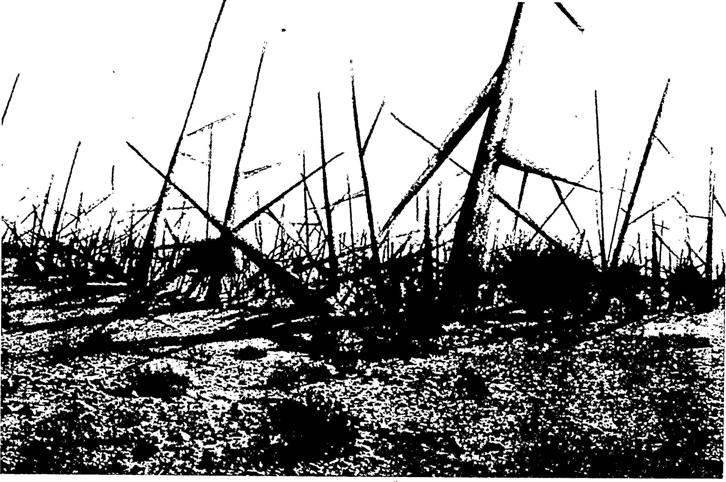
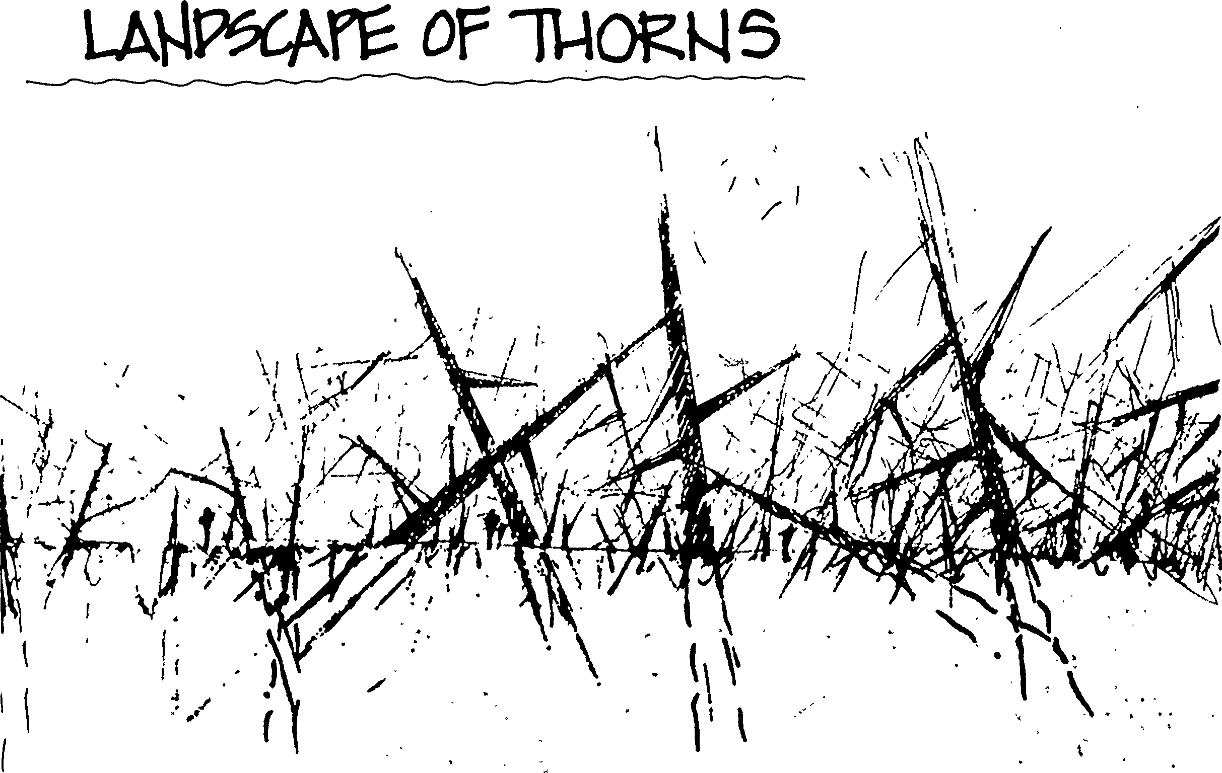

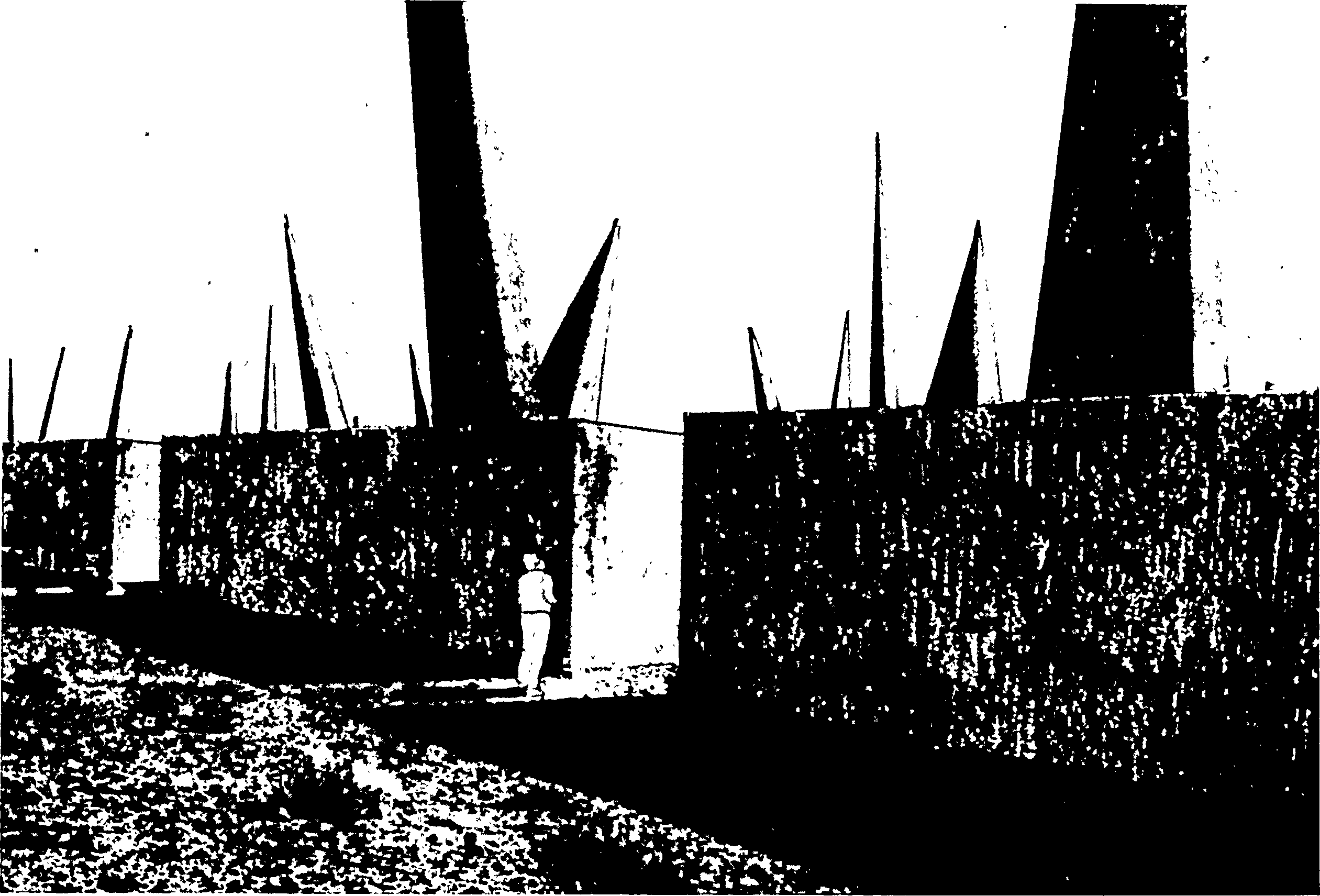
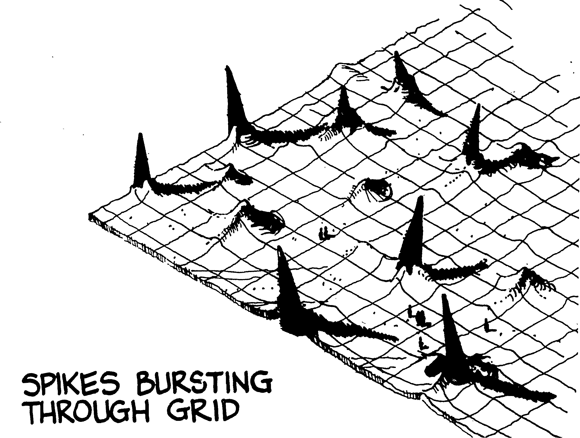
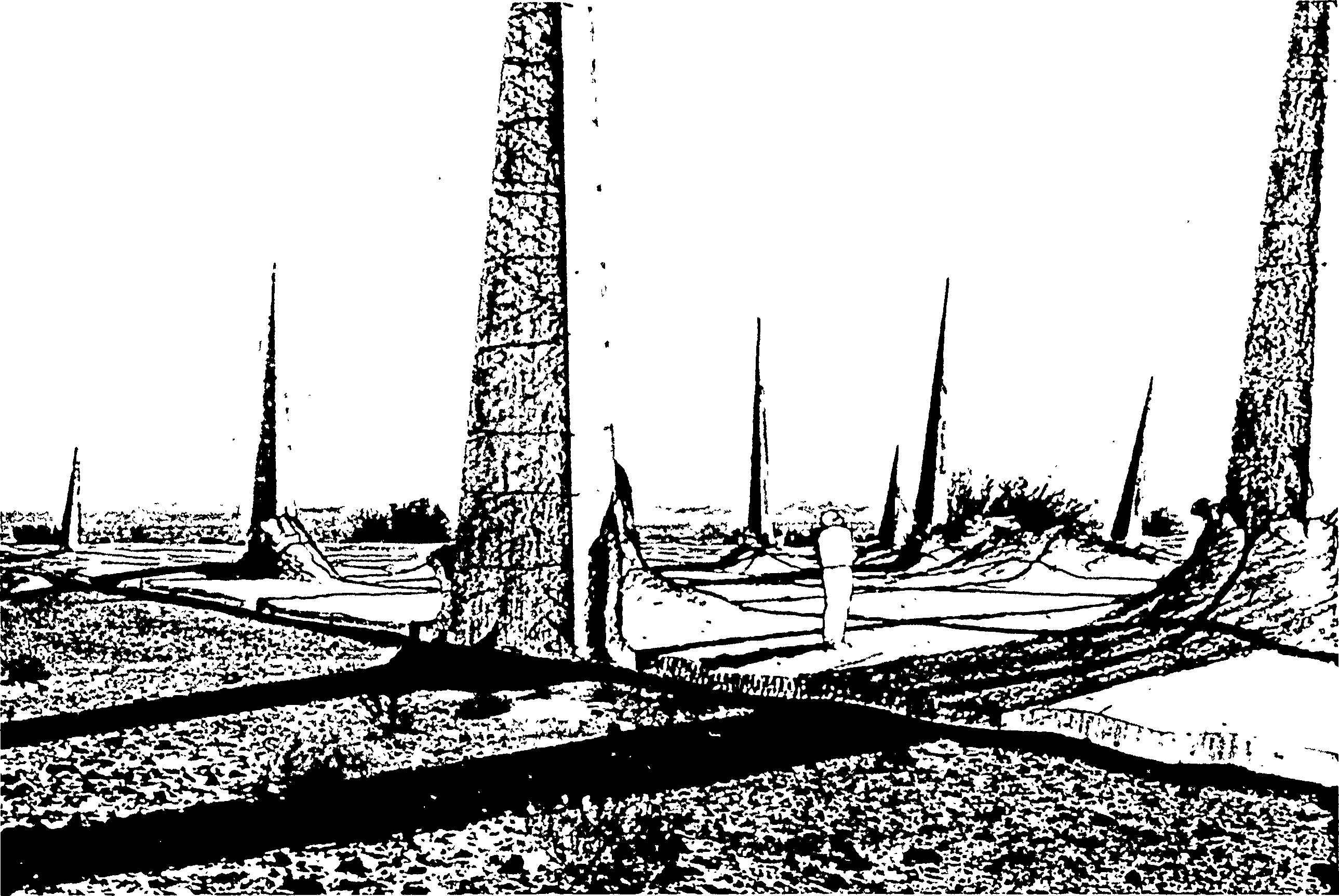
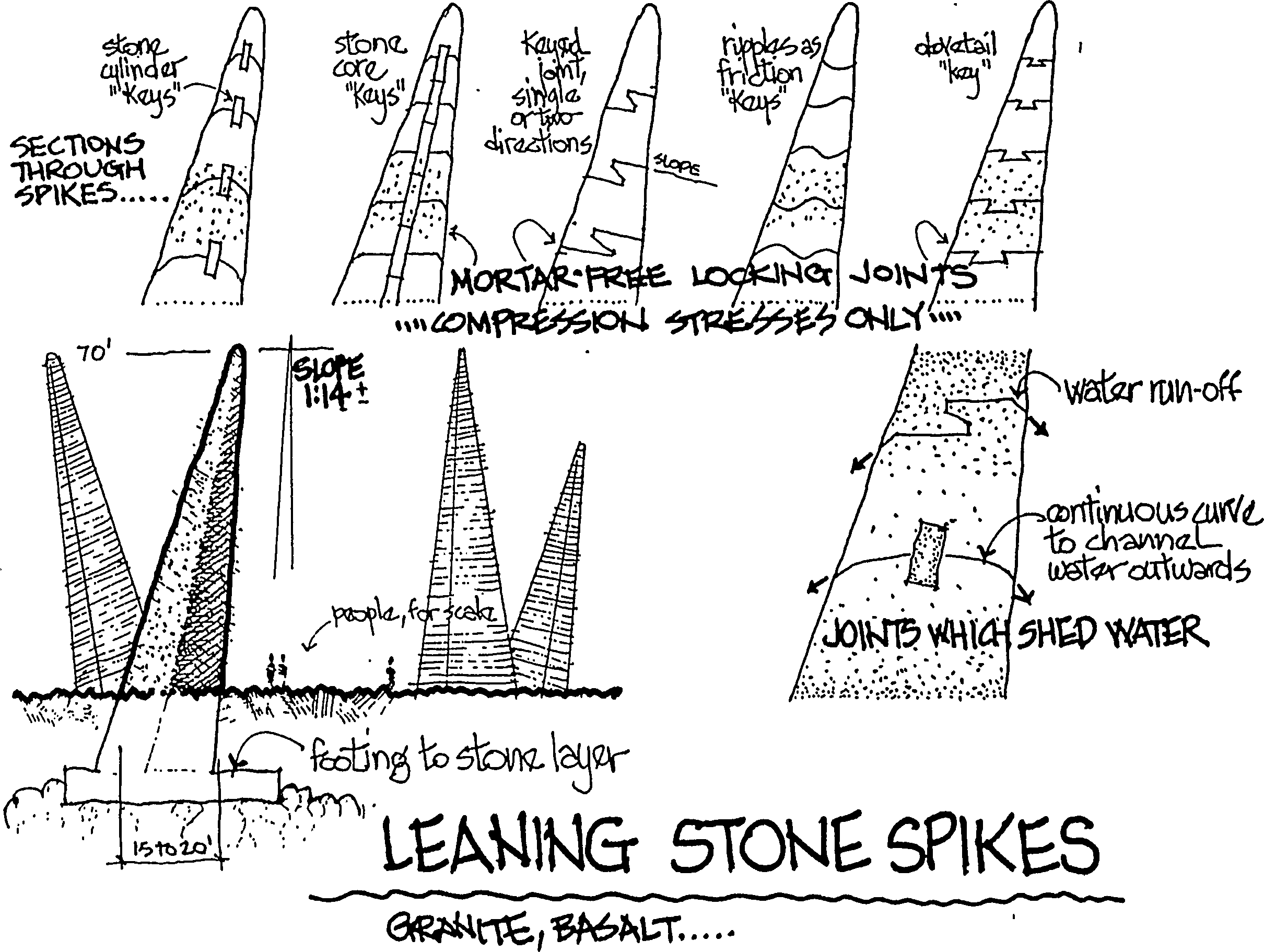
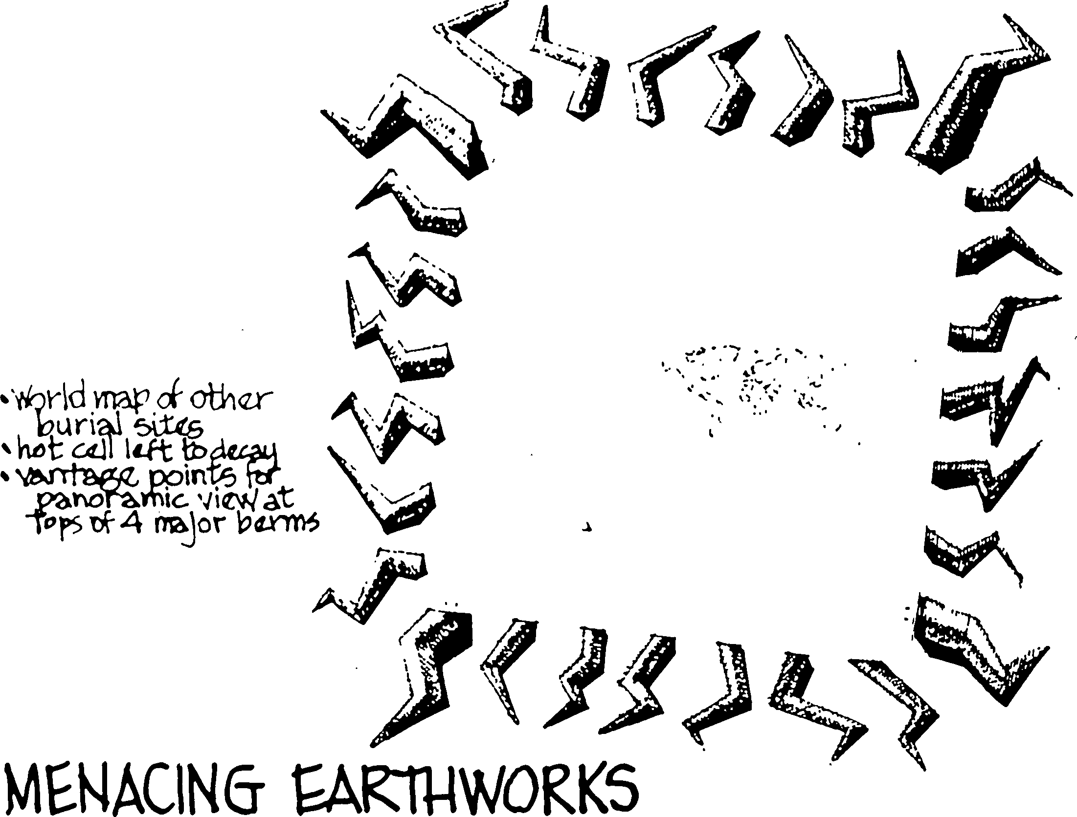
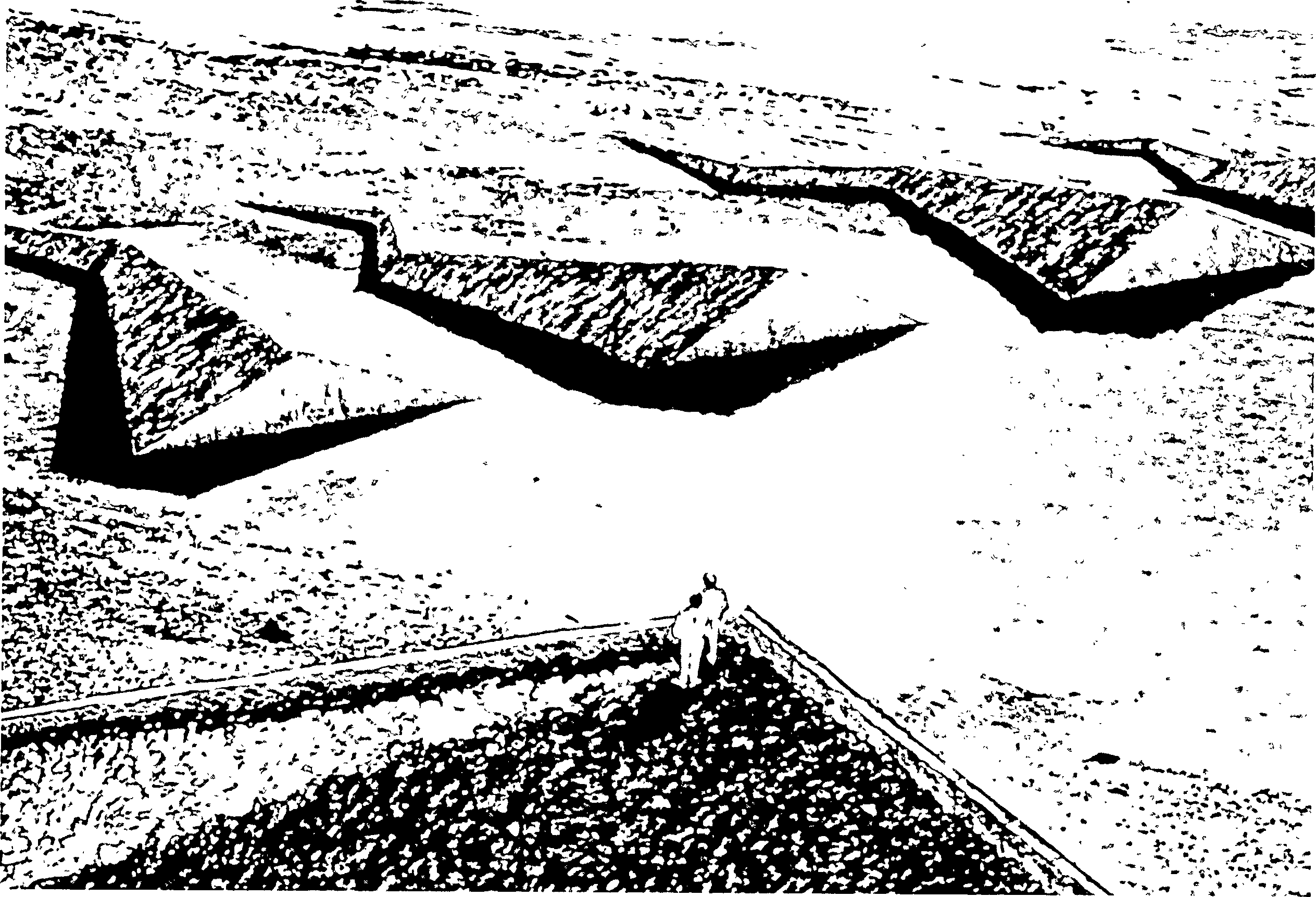
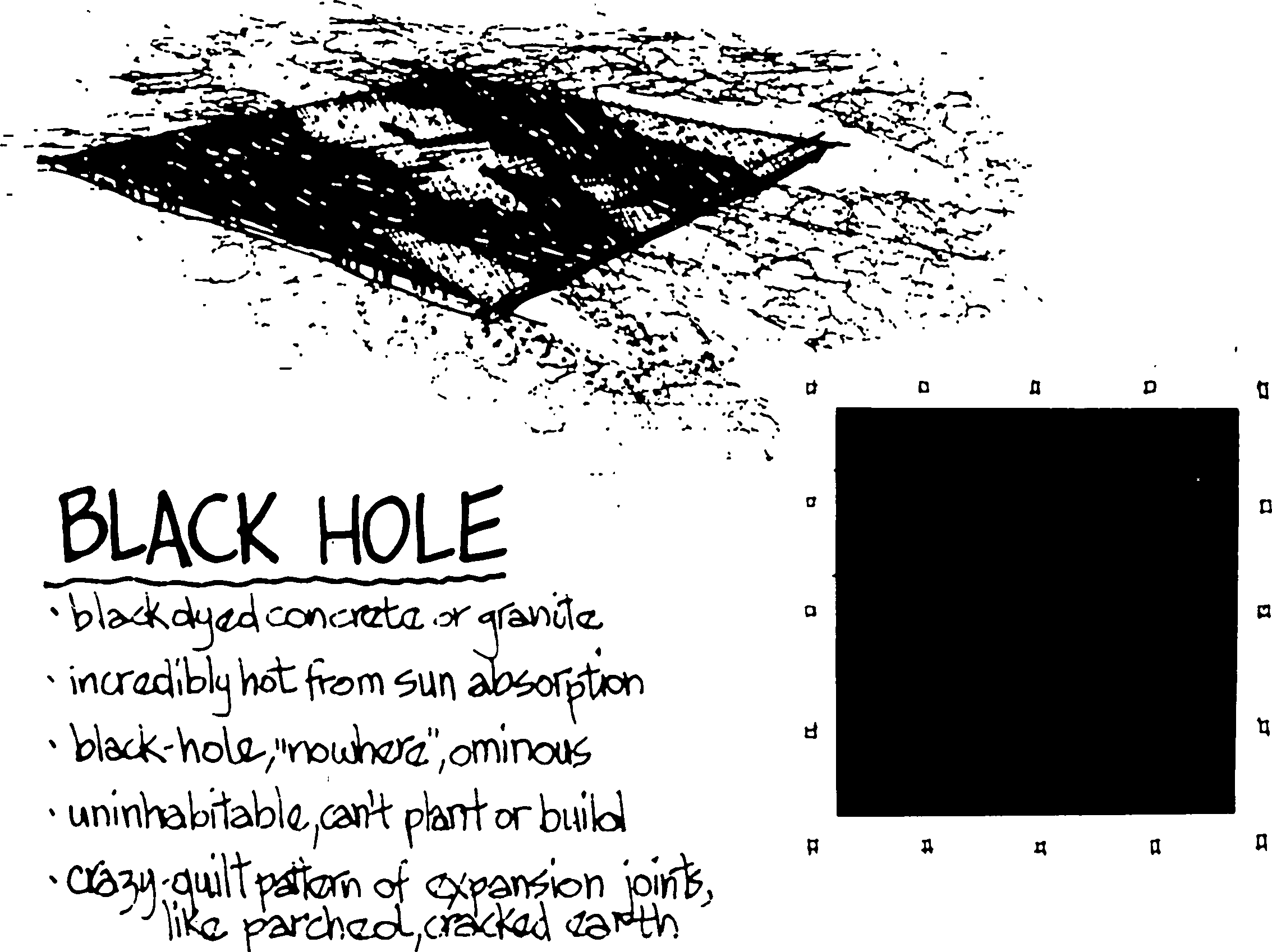
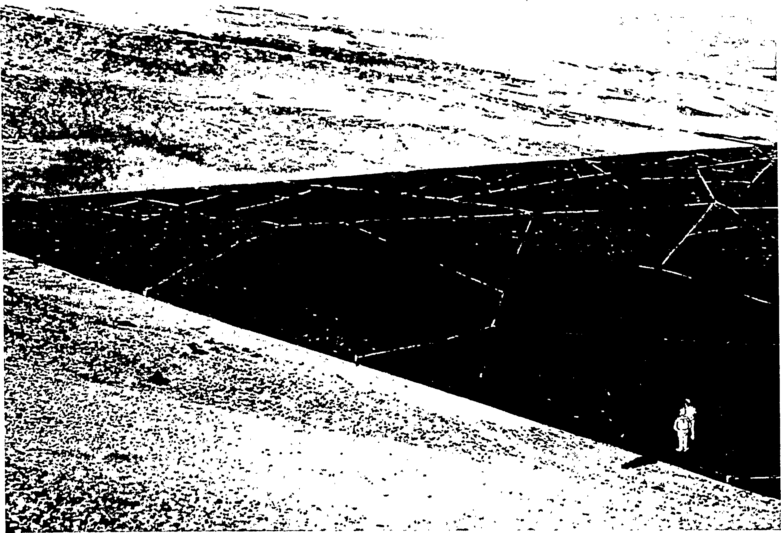
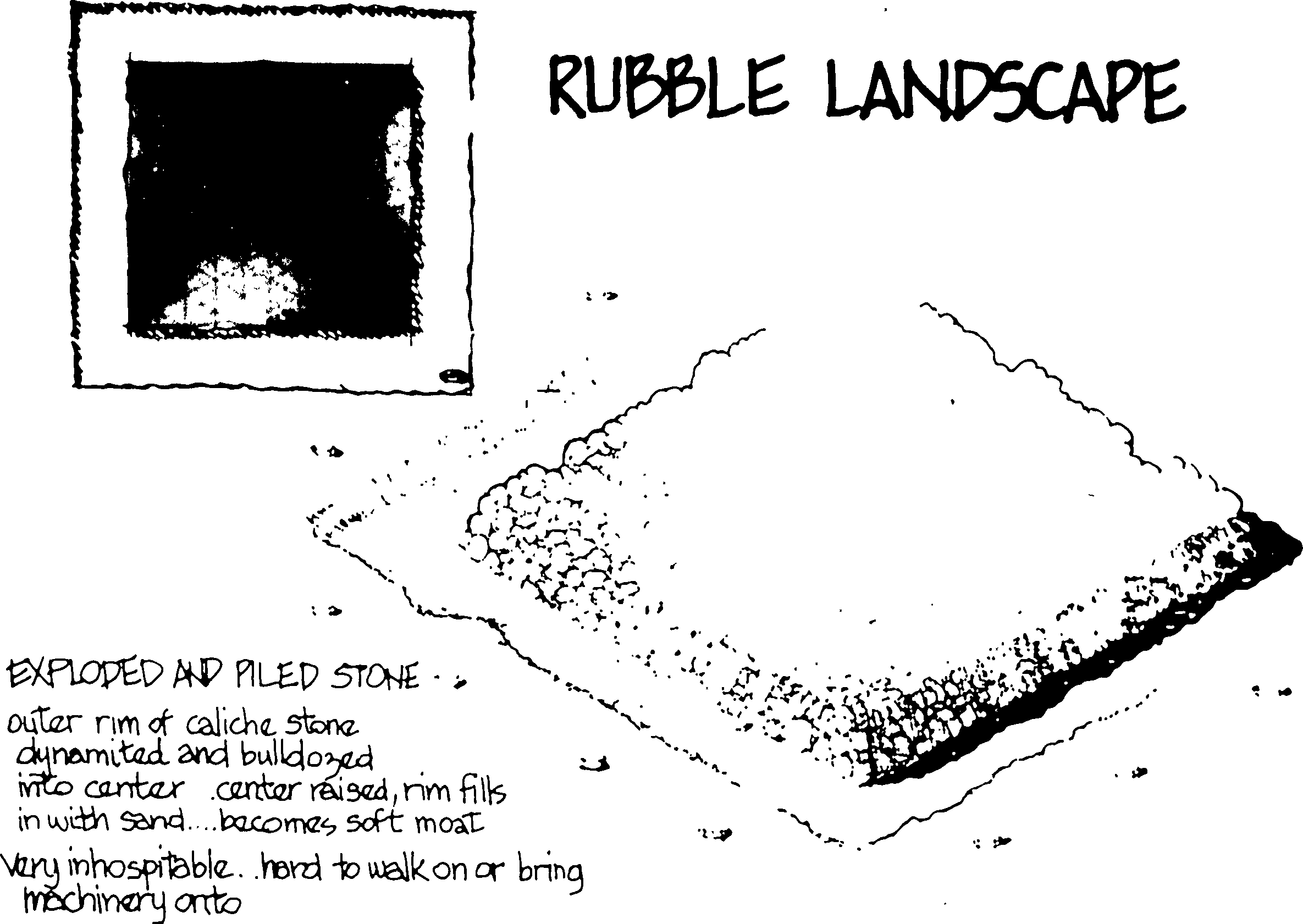
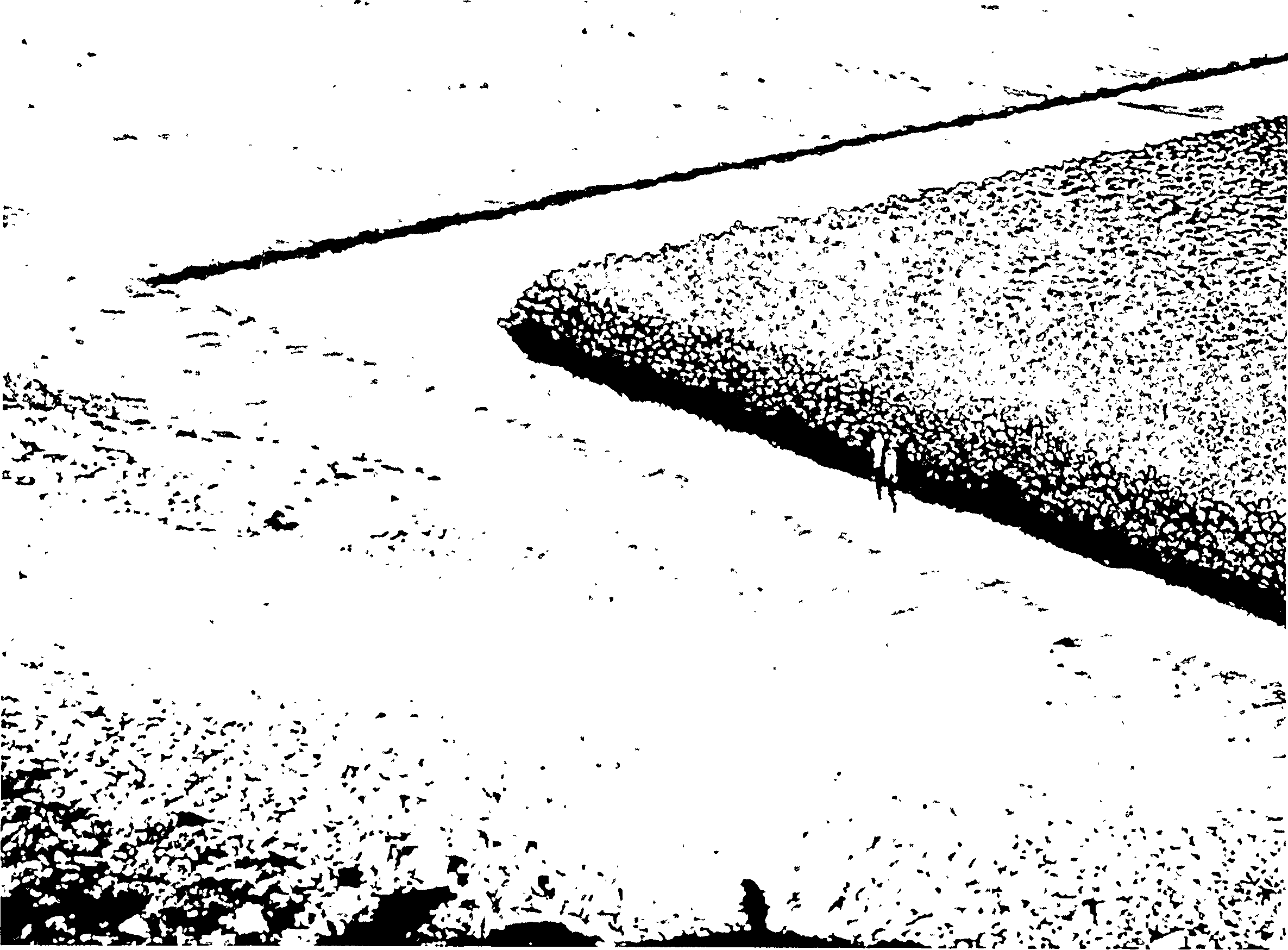
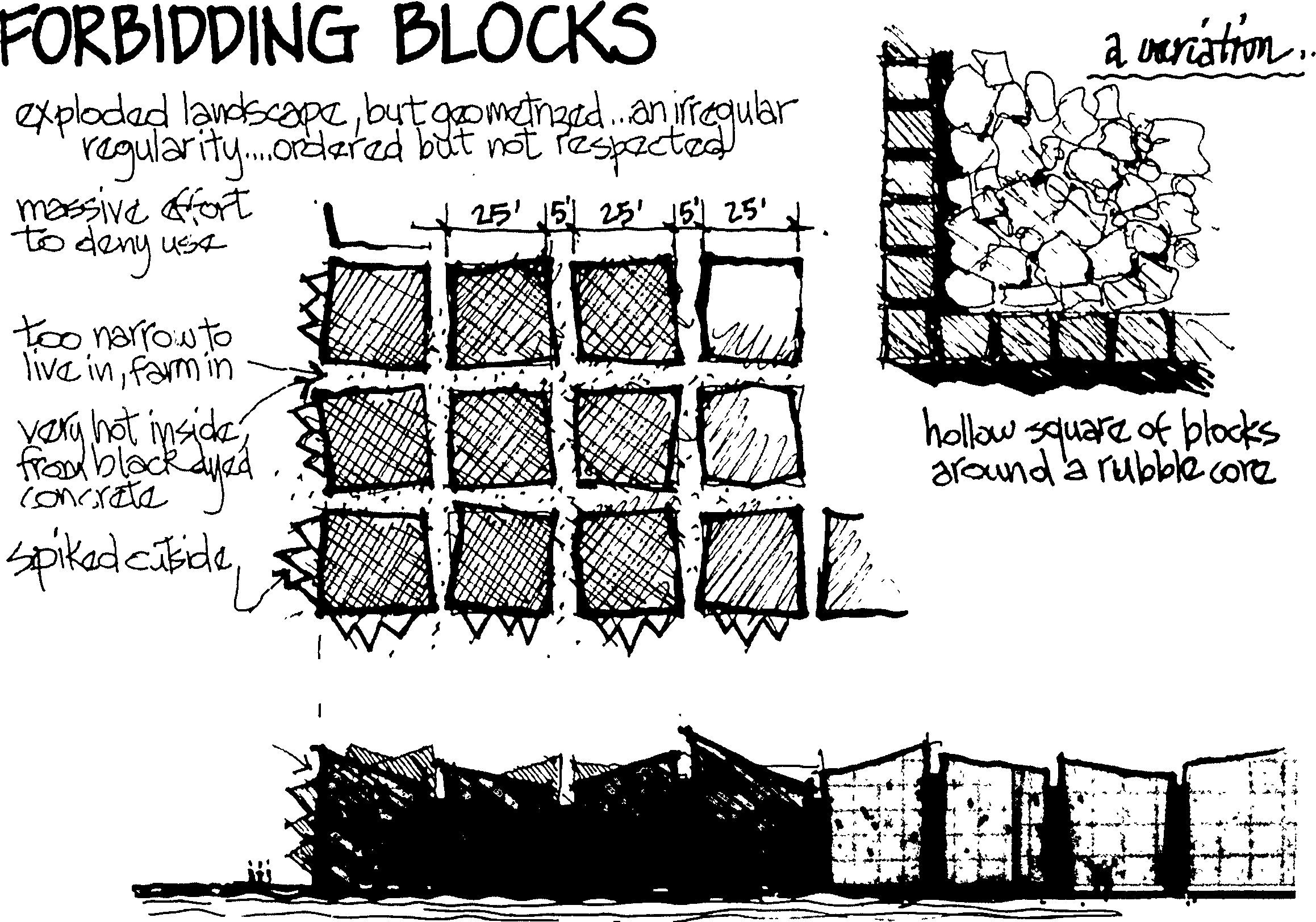
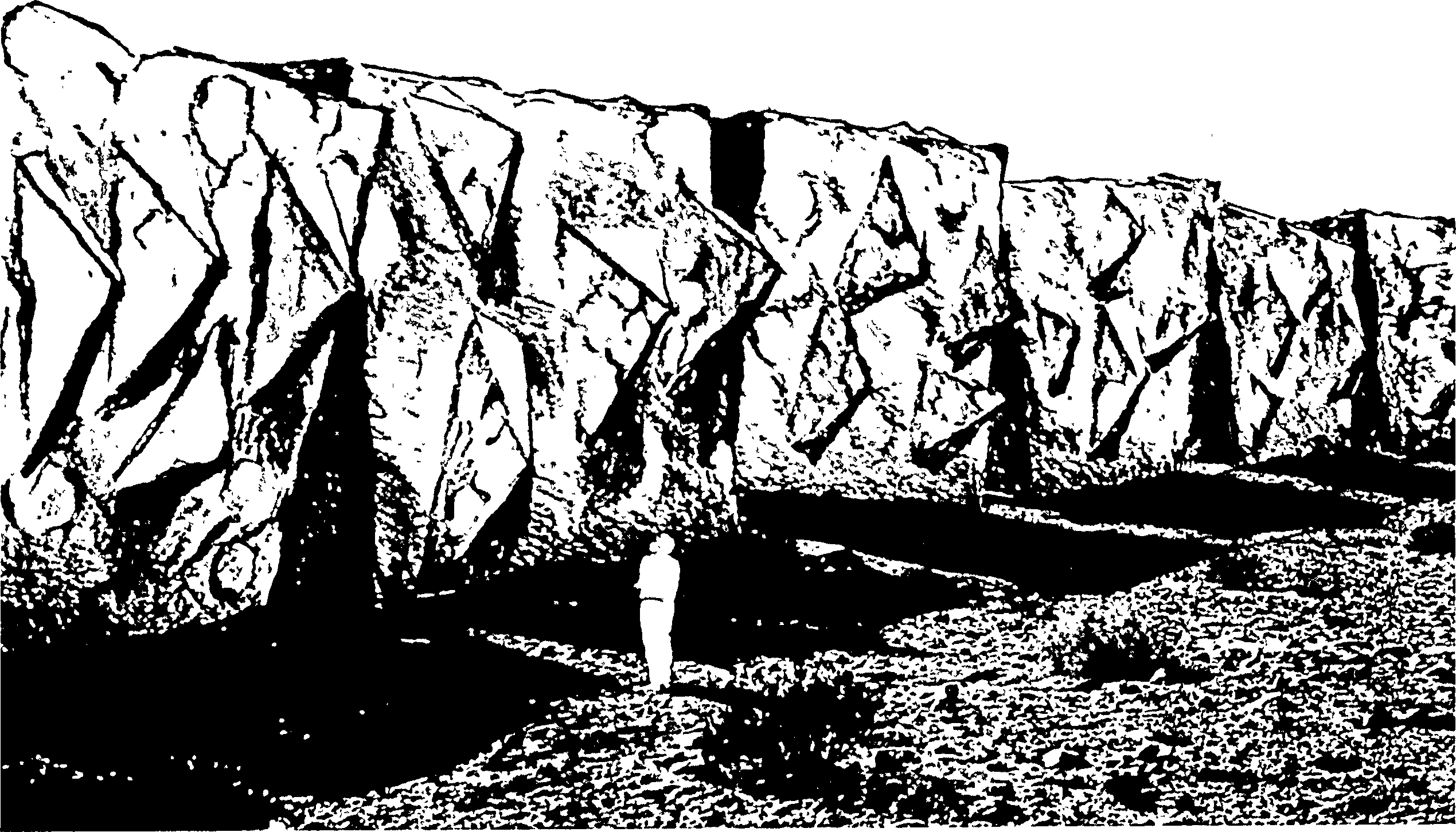
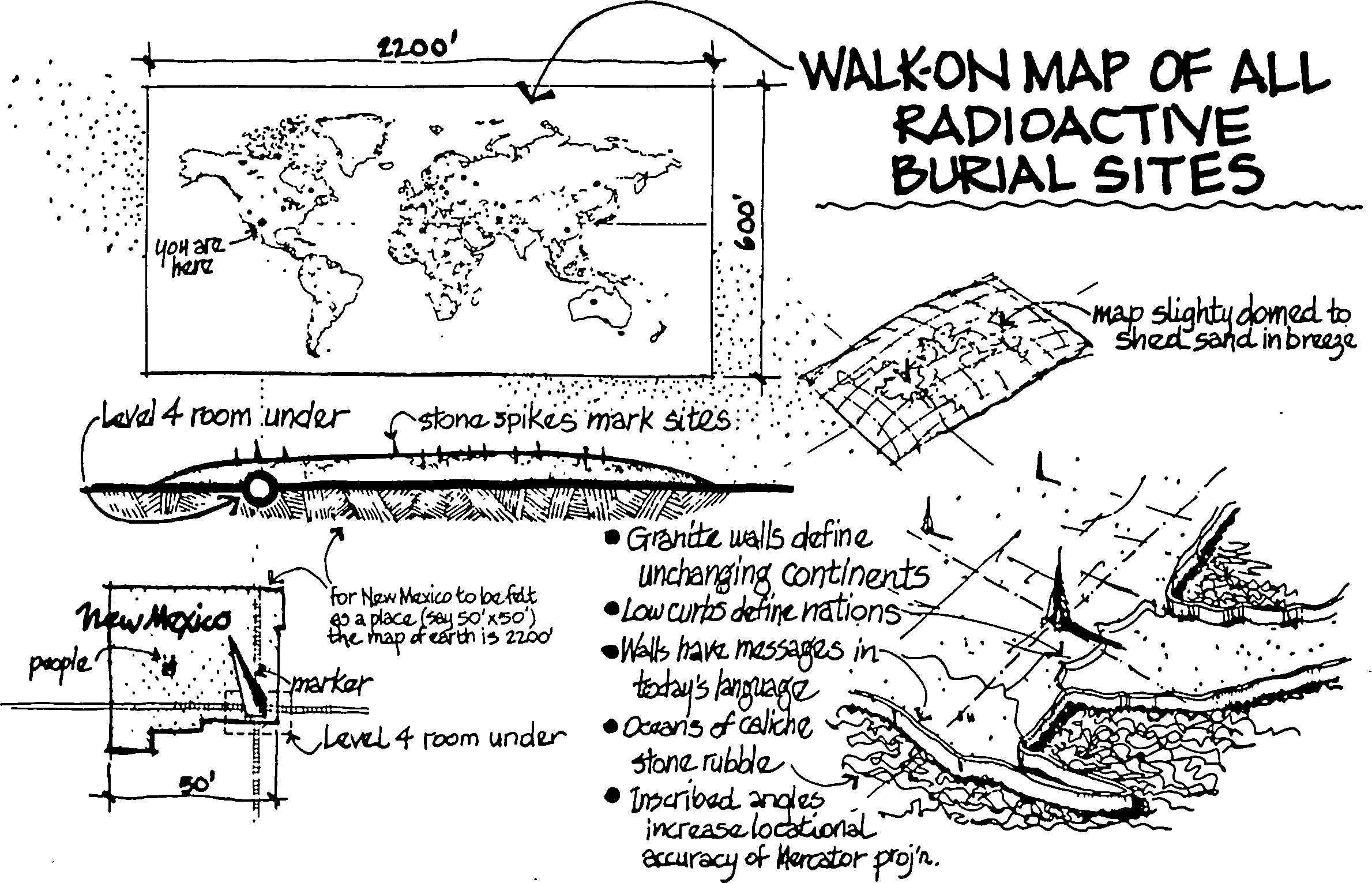
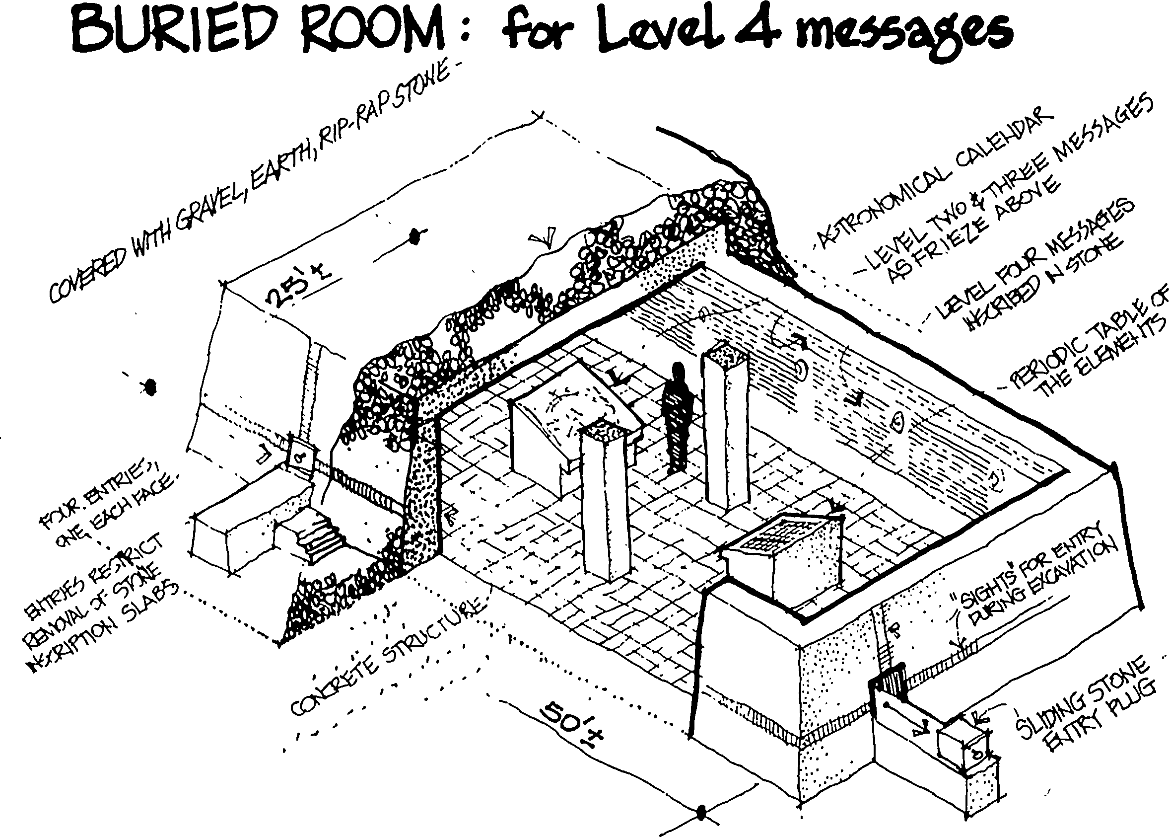
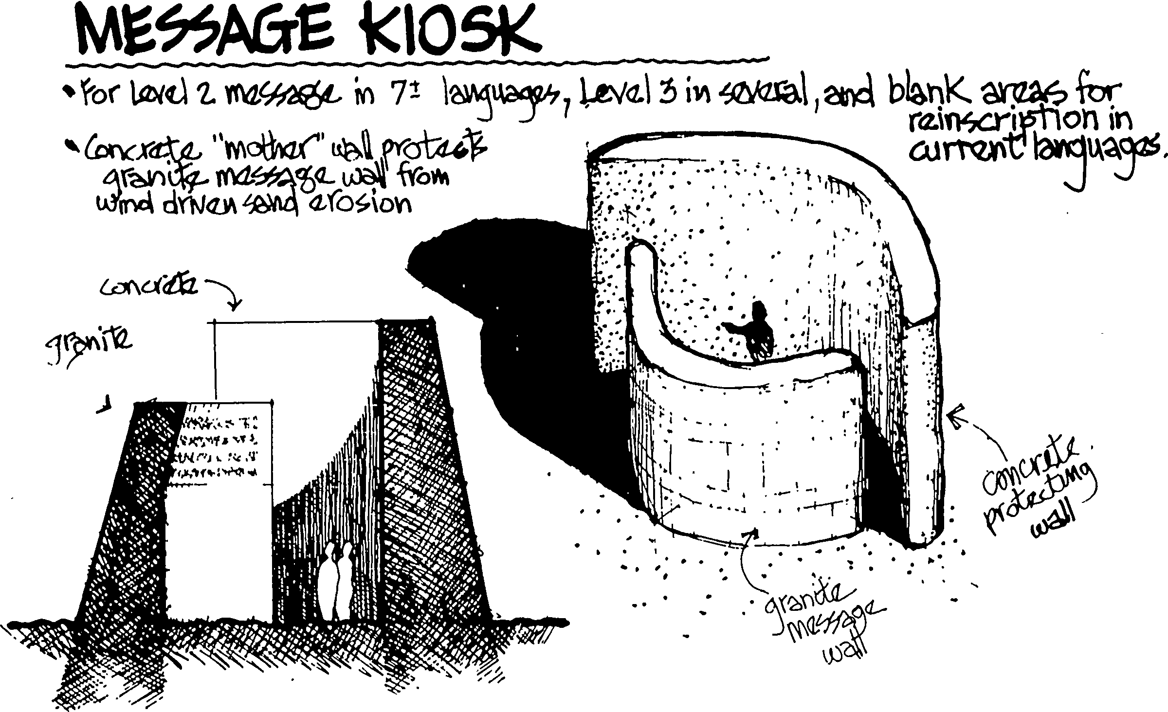
4.4 Durability of common marker structures
4.4.1 Introduction
This section discusses the durability ofvarious proposed above-ground and below-ground marker structures.
The charge to the panel is to make recommendations to mark the site with "durable" markers. In what follows we take the position that "durable" in addition to meaning "resistant to decay by forces of nature" shall mean "resistant against removal by man."
A marker system designed to be "durable" against attempts of individuals to remove or deface markers (vandalism, recycling) can also be designed to offer very different degrees of resistance against removal by future societies.
Various scenarios can be envisaged under which future governments would want to remove the marking system, either in order to increase the economic value2 of the site or to deter advertent intrusion into the WIPP.3
On balance, the team recommends a marker system designed to be as difficult as possible to remove by future societies.
4.4.2 Should all Markers be Durable?
Clearly, some markers at the site must endure for 10,000 years. However, this does not imply that all markers must endure for such time. For example, if we accept the prediction of the Futures panel that drilling for oil and gas will cease within the next 200 years, then it would make sense to design a sub-set of markers with a design life of 300 years, containing specific warnings--in English and Spanish only--against drilling for hydrocarbons at the site.
Furthermore, such markers could be designed to shield for some time the more elaborate, complex and durable markers required to warn societies in the more distant future. Thus, the wooden structures bearing warnings not to drill at the site might contain monolithic cores of granite inscribed with the full set of Level II and III messages.
4.4.3 Categories of Markers
We shall use the term marker both for structures that are messages in themselves ("something man-made is here") and for structures that provide space for graphic and written messages. In addition, buried structures designed to introduce anomalies in the gravimetric, seismic, electrical conductivity, and magnetic profiles of the site are considered to be markers, because they will help to locate the site even if all surface structures were to be obliterated by unforeseen events.
4.4.4 Distinction Between Markers and Barriers
Consideration of barriers is not included in the charge to the panel. The distinction between "markers" and "barriers," however, becomes blurred in cases where message bearing markers cannot be read without taking physical action.
For example, to read a subsurface marker requires digging or plowing at the site, and to read markers buried at the depth of the waste panels requires excavation or drilling. Plowed up markers can be read easily, but fragments flushed up during drilling are so small that inscribed messages are likely to go unnoticed.4
Therefore, a marker system on the level of the waste panels should include a component that forces the driller closely to inspect the material being drilled into. Encounter of ultrahard material fragments, or even Thermit5 ignited by a mechanism set off by drilling through the enclosing titanium container would achieve this objective.
These "attention getters" have been treated as part of the marker system, as their purpose is not to prevent physical intrusion but to force attention to the markers.
4.4.5 Five Principles to Maximize Durability
Longevity of the marker system can be improved by adhering to five basic principles:
-
Setting up a benign environment:
How long a material lasts is frequently determined more by the environment than by the material's inherent properties. In a benign (i.e., a dry and low humidity) environment even organic materials can survive for long times (papyrus, mummies). On the other hand, even highly corrosion resistant materials are likely to disappear in a wet, "aggressive" environment, as, for example, a hot brine solution.
Therefore, a general principle to ensure marker survival should be to set up a "local" environment beneficial to the marker's survival.
Examples would be locations shielded by berms or sacrificial walls against wind driven erosion and by overhangs against precipitation. For buried markers, archaeological finds in New Mexico can provide guidelines for setting up beneficial environments.
For example, the New Mexico Museum of Natural History in Albuquerque contains a stunningly well preserved skeleton of a young camel that roamed in the Albuquerque area 10,000 to 20,000 years6 ago when the climate was wetter than today (see Figs. 4.4-1 to 4.4-4).7 @link This skeleton was found in a bed of sand and gravel in a commercial gravel pit just outside Albuquerque. The skeleton, down to the smallest vertebrae at the tip of the tail, is perfectly conserved. Thus even a material of medium durability8 can survive for very long times without losing small features when embedded in a suitable environment (sand and gravel). To duplicate these conditions for buried markers, one of us (DGA) has acquired some data on the Albuquerque site. The site consisted of a mixture of alluvial sand and gravel (one to a few inches thick). The recommended strategy, therefore, is to bury important markers, particularly those in the access shafts (see Section 4.4.9.12) @link in an appropriate mix of well-drained sand and gravel.
Similarly, guidelines for setting up conditions maximizing the survival of inscriptions on markers can be extracted from Indian rock carvings, even though the age of the oldest of these is about one tenth of the design life of WIPP marker system.
-
Avoid mixing materials in a single structure.
Bringing different materials into contact opens the possibility for chemical reactions.9 In a non-sliding contact, temperature changes will create thermal stresses unless the thermal expansion coefficients are matched. Thus, it is best not to mix different materials in the construction of a marker (e.g., use engravings, not inlays for inscription).
If contact of different material cannot be avoided, as for example at the interface between a concrete foundation and the ground, it is important to minimize the possibility for chemical reactions (e.g., by inserting an impervious clay layer between concrete and soil containing sulfates).
-
Working with large size components.
For illustrative purposes, let us as assume that a marker weathers at the rate of 1 mm/year. Although a small value, it will amount to more than 30 feet over the design life of 10,000 years. A structure a few feet in size will disappear but a structure many feet in size will lose
@figure(4-4-1) @figure(4-4-2) @figure(4-4-3) @figure(4-4-4)but a small fraction of its volume. Thus size is an important factor in durability. It is no accident that structures that have survived in their original shape (pyramids, Fig. 4.4-5; sphinx, Fig. 4.4-6; monolithic tombs, Figs. 4.4-7, 4.4-8) for long periods of time are very large. (Note, for example, the scale of modern buildings in the background of Fig. 4.4-6 to the sphinx.) Thus, it is important in above-ground structures to work with marker structures of large size.
Because erosion tends to progress linearly in time,10 it makes little sense to use a logarithmic time scale in judging a marker system. That is, the probabilistic division into near future (order 100 years) medium future (order 1,000) years and far future (order 10,000 years) has no physical base even though it pleases human perception.
Interestingly, the principle that size promotes durability extends all the way to everyday constructions. Biczók [Ref. 4-2] states that large (on the scale of meters) concrete structures, all other things being equal, are much more resistant to erosion than small ones. Empirical observations over several decades show that the actual corrosion of concrete structures (which for concrete is usually moisture related) is much smaller than expected from laboratory experiments on small specimens (Biczók [Ref. 4-2] cites the example of a mortar sample that had survived in excellent condition in seawater for 17 years, but when enclosed in a barrel filled with the very same seawater completely corroded in 16 days).
-
Redundancy
Fourth, because it is difficult to foresee all possible scenarios detrimental to survival of the markers, redundancy must be applied to every physical aspect of the marker system, i.e., to location (above, semi-buried, and below-ground structures), structural design elements (berms, monoliths, rooms), and materials selection.
Monoliths of stone should be made from rocks of granite, basalt, and sandstone; concrete structures from portland-, aluminous-, or ferro-cements; scattered markers from fired alumina, beryllium oxide, earthenware, porcelain, single crystal sapphire (e.g., aluminum oxide discs), different glasses (pyrex, borate), and maybe even metals (titanium, stainless steel).
To preserve a readily perceived pattern, the placement of materials, where possible, should alternate in a sequence (i.e., one monolith of basalt, followed by one of Sandia granite, followed by one of Vermont granite, followed by one of sandstone, etc). Scattered markers made from different materials should be arranged in concentric rings or radial rows.
@figure(4-4-5)
@figure(4-4-6)
@figure(4-4-7)
@figure(4-4-8)
-
Using on-site testing data in the design
On-site testing of marker materials will allow a better informed choice of materials. This is particularly important for concrete, a material with higWy variable properties, see below.
The anticipated operation time for WIPP, 30 to 40 years, is sufficiently long to acquire meaningful upper limits on the erosion rates of materials planned to be used in the marker system.
One of the panel members (DGA) examined the 30-year-old concrete Gnome marker, marking an underground nuclear test explosion located a few miles from the WIPP site. Based on its appearance (but excluding the already visibly eroded water retaining depression on the top) the amount of concrete eroded over that time period appears to be, at most, 1 mm.
If we take this value as an upper limit and extrapolate it to 10,000 years, we obtain 36 cm. As this exceeds the width of the marker, it may disappear.
The above estimate can be criticized from many aspects (e.g., corrosion rates may speed up as the surface becomes less smooth; failure might be of some other mechanism, or from lighting, tornadoes, nuclear explosions, etc.), but it illustrates two important points:
- Data useful to predict erosion of marker structures can be acquired over 30 years, that is, before WIPP is scheduled to close.
- These test data provide guidelines for the minimum feature size of such structures.
The Portland Cement Association, PCA, (Chicago) started in 1940 the long-term testing of concrete at 13 U.S. sites [Ref. 4-3]. Progress Reports are published every 10 years. The test set-up at the WIPP site should use the PCA test set up so that results obtained can be linked to a data base going back to 1940.
4.4.6 Environmental Factors
Site factors influencing survival of markers at the site are climate (temperature cycles and precipitation), wind (tornadoes), wind-blown sand, soil chemistry, surface and ground water, and natural calamities (lightning, earthquakes).
The present climate at the WIPP site is semi-arid. Even if rainfall were to double (which is the worst case prediction for next 10,000 years @ref(4-4)), the evaporation rate would still exceed the precipitation rate and the climate would remain favorable to the survival of materials.
A site-specific study of wind and tornado probabilities at the WIPP site has been prepared by Fujita @ref(4-5). This study predicts a 10-4/year (@TODO: superscript) probability for 119 mph straight line gusts and 80 mph tornadoes. The most severe credible tornado that could be expected to occur at the WIPP site, with a probability of 1% over the next 10,000 years, would have a maximum wind speed of 183 mph and a pressure drop of 0.69 psi. To ensure longevity, above-ground markers must be designed to withstand the latter conditions.
Dunes are present at the site and are likely to move, and therefore may bury structures and supply sand for wind-driven erosion @ref(4-6). To ensure continued visibility, above-ground structures must therefore exceed a height of 30 feet.
The panel had no data on the probabilities of earthquakes. An earthquake occurred during the time of this study (Jan. 92). The quake was centered in western Texas/eastern New Mexico and registered 4.6 on the Richter scale @ref(4-7).
Because the durability of concrete depends to a very large degree on soil pH, presence or absence of sulfates and chlorides, and contact with the ground water table [Ref. 4-8], on-site data for these parameters must be acquired, should the marker design make use of this material.
4.4.7 Feasibility Demonstration that Durable Markers can be Constructed...if Cost is No Object
4.4.7.1 Longevity Principles in the Classical Pyramid Design
Although guaranteeing survival of structures or markers for 10,000 years appears to be a formidable task, it is straightforward, in the absence of other constraints (e.g., costs, psychological effectiveness), to design a marker system that will be able to transmit engraved and other physically carried messages for ten millennia, provided humans do not disturb the site.
An example would be a 300 × 300 feet pyramid, constructed of 9 × 9 × 9 feet (or larger) square blocks of granite. No mortar would be used, and all six sides of each block would be engraved with the full set of Level II and III messages. Thus, should engraving on the exterior surfaces erode with time, future generations would only have to lift one block to uncover a fresh inscription of the same information.
As over 90% of the Cheops pyramid is still extant after 4,600 years (see Fig. 4.4-5) @ref(fig 4.4-5), there is no doubt that such a construction, if left undisturbed, would preserve inscribed messages for 10,000 years.
The pyramid design (Fig. 4.4-9) @ref(fig 4.4-9), put forward as an illustration only, incorporates the following design principles:
- Use of all available surfaces to carry messages.
- Redundancy--the message is repeated many times.
- Time evolving messages—as one surface erodes, other, new ones, emerge.
- Both "exterior" and "interior" storage of messages (the core of the pyramid could be considered as a cave filled with message carrying blocks).
- Easy and obvious access to interior messages.
- All components are made of the same material, eliminating problems that can arise when materials with different thermal expansion and chemical potential are in a non-sliding contact.
- The structure is tapered with a slope less steep than the talus slope.11 Even when shaken by a large earthquake, the structure, therefore, would largely retain its original shape.
- The load bearing stress is compressive (i.e., tends to close any crack that might form).
- No tensile surface stresses exist (which would promote crack opening if a crack were to form).
The above example also illustrates that a design guaranteed to survive 10,000 years will be expensive. Assume that 9 × 9 × 9 feet granite blocks are to be used and that a single block, including engraving, could be fabricated for $5,000. The cost of the material alone, then, would amount to $62 million. This would be about 6% of the to-date cost of WIPP but less than 1% of the projected cost of WIPP over its operating lifetime.
The high cost of the design is not accidental. Any realistic consideration of proposed marker systems will show that a tradeoff exists between longevity and cost. Any above ground marker system secure against the forces of nature is, by necessity, a large system made out of durable materials, as only such a system can afford the loss of material over time without losing its function.
Therefore, a meaningful probabilistic estimate of the survival of the marker system can only be made if the cost that can be spent on the system is known.
4.4.7.2 Shortcomings of a Pyramid Design
In addition to high cost, a "classical" pyramid design has the following shortcomings:
- The structure is somewhat difficult to see from an altitude of 30,000 feet (aspect ratio 1:100),
- If smaller blocks are used, it is easily climbed, rendering all exterior message bearing surfaces accessible to vandalism,
- The use of quadratic blocks encourages alternative use of the components by future generations (“quarry”), the form of the structure is one often used to mark honored phenomena and may embody an inappropriate message in its form.
Good visibility from the air is highly desirable, as mankind is likely to continue the use of air transportation. Thus, a large population (conceivably even people off-site who make decisions about drilling) can be made aware of the existence of the site by choosing a large design that could easily and unambiguously be identified from the air as a nuclear waste site. This would require a standard large scale design for all nuclear disposal sites. (One solution, which hinges on the continued use of the radiation sign for the next 400 generations, would be earth berms formed into the radiation trefoil sign with a ring of monoliths forming a central circle. Such a design is discussed by Team B. However, the continued use of any cultural icon over 400 generations is uncertain, see Section 3.3.) @ref(section 3.3)
4.4.8 Minimizing Marker Removal by Humans
Without doubt, the major threat to the survival of markers is human activity, not nature. Metals in historic sites have nearly always disappeared,12 and buildings have been used as quarries (note in Fig. 4.4-5 @ref the removal of the more valuable cladding layer13).
@figure 4.4-10 Figure 4.4-10. The Pantheon. This building, which uses, in part, concrete still stands after 1,800 years. Copyright (c) 1976 by Jacquetta Hawkes. From The Atlas of Early Man. @format Reprinted through special arrangement with St. Martins Press, Inc., New York, NY.Vandalism of monuments has been a problem, even when the site commemorates a revered personality, as in the Washington Monument [Ref. 4_9] @ref(4-9).14
For this reason we recommend the construction of closed Level IV rooms.
Finally, as discussed before, an organized, large scale activity by future societies to remove the marker system is conceivable.
General guidelines to minimize removal of above-ground marker structures are:
- Use of inexpensive materials. Examples are materials found at the site (e.g., caliche) and to a degree concrete.
- Use of otherwise not easily usable materials and building blocks. Examples are brittle materials prone to break when reshaped and large blocks shaped in odd forms. By odd forms we mean specifically forms that can not readily be assembled to fill space (like rectangular block). For example, equal sized blocks of five fold symmetry cannot fill space continuously.15
- Further to discourage alternative use of irregular shaped components, each component should be shaped such that it cannot rest without rocking or falling over on a flat surface.
- Using interlocking structures involving irregularly shaped blocks that can be assembled into
one form only. A computer code to arrive at such a design should take into account:
- Generation of flat surfaces of minimum area to hold desired messages (this would apply only to structures designed to hold time released messages).
- Design of components that cannot rest stably on a flat surface (to discourage alternative use as a weight).
- Self-locking assembly into final form.
- Stability against ground motions caused by large earthquakes.
- Drainage of any water that may enter outside surfaces.
-
Use of obnoxious materials
Obnoxious materials are not likely to be removed. However, materials obnoxious in the sense of “bad smell” cannot be durable since they continuously evaporate the small fragments reaching us. Thus, they must disappear with time. However, it might be possible to enclose such materials into long-lasting glass capsules that break when stressed. The glass of choice would be lanthiumborate.16
Another long-lasting obnoxious material is a material with a low level of radioactivity. Thus, one could consider the display of small amounts of clearly marked quantities of low-level radioactive materials with long lifetimes (e.g., low-grade uranium containing ores).17
- Maximizing the labor component, minimizing material value. An example would be the construction of a very large earth dam from material at the site.
-
Maximizing the ratio of work required to remove the structure to that required to make the structure.
This principle strongly favors the use of reinforced concrete, as structures made of such material, when large, are very difficult to remove, while the work for construction is relatively modest. This is very different from a design made out of shaped blocks of stone that requires much more work to make than to disassemble.
The concrete bunkers of the Maginot and Siegfried lines, therefore, have not been removed, in spite of intense political pressure from the local communities, whereas much of the building stones of the colosseum in Rome have been recycled.
-
Using above-ground components that are large and heavy (say with minimum dimensions of 6 × 6 × 6 feet, or a minimum weight of 18 tons). Such weights are difficult to remove with farm equipment18 but easily handled by today's cranes.
The builders of Stonehenge (1500 BC) used blocks of up to 54 tons in weight (Fig. 4.4-11). @ref(fig 4.4-11) The builders of the West Kennet tomb (3000 - 2000 BC) used blocks of stones weighing up to 100 tons (Fig. 4.4-7) @ref(fig 4.4-7) [Ref. 4-10] @ref(4-10).
For subsurface and scattered markers, the following factors minimize the probability of removal of markers:
- Distribution over a wide area and a variety of depths.
- Use of materials that are not easily retrievable, i.e., materials with physical characteristics (density, dielectric and magnetic constants) similar to that in which they are embedded. This will make it difficult to use automated retrieval.
- Use of inexpensive materials.
Examples incorporating these guidelines can be found in Section 4.3. @link(s4.3)
4.4.9 Durability of Some Common Elements of a Marker System
4.4.9.1 Introduction
In this section, we discuss the durability of structures considered in this report. These structures are examples only, and are not meant to indicate the design of the site, which is an architectural decision.
The durability of these structures depends on their environment, their design, and the materials used. Because these factors are interrelated, materials are discussed as they would be used in generic marker elements.
Above-ground elements include the following:
- Earth berms,
- Monoliths,
- Structures generating tones or noises when blown on by wind, and
- Enclosed rooms housing Level IV messages.
Below-ground structures comprise the following:
- Subterranean markers (scattered surface markers, markers denoting shafts, markers at the depth levels of waste panels), and
- Buried magnets, electric, and seismic resonant structures.
These elements will be discussed in the above order.
4.4.9.2 Large Earth Berms
Earth berms have been used as barriers (e.g., in fortifications) and to define areas (e.g., in formal gardens). Based on the historic record (prehistoric mounds, Roman lines,19 Hadrian's wall) the probability that large earth dams survive for 10,000 years is very high.
They should be made out of material found at the WIPP site to minimize their material value and should be designed such that their removal requires much work.
The earth berms should be covered with caliche (white) that will (at least temporarily) increase contrast with the environment (light brown). This contrast will increase visibility of the site from the air. Consideration should be given to the size and orientation of shadows thrown by the berms so as to maximize visibility (and, possibly, to generate forms of artistic interest).
To avoid the possibility that significant sections get burled by migrating dunes (estimated to reach heights of 30 feet), the minimum height of these earth berms should be 50 feet. This requirement together with the talus slope, determines the minimum lateral extension. Except for this constraint, the longitudinal extensions are matters of design.
The area outlined should coincide with the lateral extension of radionuclides at the storage level. That is, with the waste panels plus the upper limit calculated for the lateral movement of radionuclides by appropriate transport mechanisms (diffusion, percolation, and convection).
Earthworks do not provide surfaces suitable to carry message bearing inscriptions, but their construction should be combined with the following:
- Interment of scattered markers whenever possible.
- Interment of conductors to mark the site by man-made changes in soil conductivity.
- Interment of magnetic markers, to mark site by magnetic anomalies.
- Construction of sealed and buried rooms containing Level IV information (see Sections 4.4.9.9 and 4.4.9.10 for details). @link
4.4.9.3 Monoliths Made of Stone
Monoliths made out of natural stone have survived for 3,500 years at Stonehenge, quite a wet climate. At the WIPP site, monoliths are very likely to survive at the site for 10,000 years if bedded properly and left undisturbed.
Monoliths (and walls formed of monoliths) are suitable carriers for Level II and III information. To minimize the probability that the inscribed information will be destroyed by acts of vandalism, a monolith must have a height such that at least one set of these messages is not accessible to a standing person, or a person on horseback or standing on top of common farm equipment (wagons, pickup trucks, tractors). One of the areas left for future re-inscription, as well, should be outside the reach of such persons.
Level II and III messages should be inscribed several times over the length of the monolith including inscriptions below ground. The topography of the engraved messages must make it clear that messages continue below ground (deeply engraved spiral band with alternating inscriptions and empty spaces for re-inscription?). Thus, if the inscriptions above ground should weather away, digging would unearth a fresh set of inscriptions.
These monoliths should:
Where feasible, be protected from wind-driven sand that can cause erosion by other design elements, e.g., on the lee side of berms or by encircling “sacrificial” walls. Their heights could vary but should not be less than 4 feet. Openings in the wall should be narrow and on the lee side of the prevailing wind.
These walls could be constructed of concrete, or of irregular, tightly interlocking stones and, if suitable, may carry Level II messages on its inside.
- To ensure a sound foundation, the buried part of a monolith should be equal to or greater than its exposed part or it should be imbedded in the rock strata below. Monoliths should be placed upright, or nearly upright to avoid the formation of tensile stresses at the surface.
- The construction material of monoliths should be natural stone with a minimum compressive strength of 25,000 psi. Suitable materials are granite (average strength 26,000 psi) and basalt (29,000 psi). The principle of redundancy favors use of a variety of materials.
- Some rocks, for example felsite (47,000 psi) are notably stronger, but we found no information on their availability. Granite can be found in the Sandia mountain range.
- The erosion of rocks by sand as measured by the abrasion test used for concrete (aggregate particles between 1/2 and 3/8 inch in diameter subjected to 500 abrasions with Leighton Buzzard sand, see Neville [Ref. 4-8] @ref(4-8)) is similar and ranges from 16.5 for limestone to 19.2 for flint (the higher numbers being worse). Thus, in regard to erosion by wind-driven sand, there is no compelling reason to prefer one natural rock material over another.
Removing the constraint of uprightness from monoliths, e.g., using diagonally inclined monoliths, considerably increases design options to mark the WIPP site (for examples of such designs, see Figs. 4.3-1, 4.3-3, and 4.3-7). @link(figs)
However, such structures will develop tensile stresses at their surface that increase with their deviation from the vertical. Tensile stresses, in a brittle material, can lead to catastrophic failure once a crack, however slowly growing, reaches a critical length.
In structures designed to last, tensile stresses therefore are undesirable. It is recommended that only a subset of monoliths be positioned in such a way and that their inclination be limited to angles that keep the magnitude of the tensile stress at the surface below 0.6 of the compressive strength of the material used. This recommendation, incorporating a safety factor of 10, is based on the observation that the strength of stone (or non-reinforced concrete) in static tension is about one-eighth of the strength in compression and that the fatigue strength is about half of the static strength.
The foundation of inclined monoliths must be such that the center of gravity coincides with the center of the foundation footprint.
4.4.9.4 Concrete Monoliths
The probability of survival of monoliths made out of concrete has been looked into by the team in considerable detail, because concrete has several advantages, notably a low price and “in-situ“ staying power, the work to remove or recycle heavily reinforced concrete being exceptionally large. More details on concrete can be found later in the various discussions of rooms.
If used as a construction material, only a subset of monoliths should be fabricated with concrete, and the overall design should take into account that this subset may disappear after 2,000 to 5,000 years (see below).
To ensure survival for that (and possibly even a longer) time period, the following practices must be adhered to:
- High quality, 20,000 psi, concrete is to be used.
- Sacrificial walls are to be installed at the base of the concrete monoliths to provide protection against wind-driven erosion.
- The monolith is to be sized and designed to remain stable and upright even if eroded (possibly unsymmetrically resulting in an unbalance) to such an extent that the loss of material may reach the order of tens of centimeters, with the exact value to be determined by the outcome of test results at the site.
- Soil at the foundation is to be checked for sulfates and chlorides, and, if necessary, an intermediate bed of clay or other impervious material is to be inserted to separate the concrete footing from the soil.
- The footing is to be in a well-drained stratum.
The protection of steel reinforced concrete monoliths against lightning is a subject of further research.
4.4.9.5 Composite “Monoliths”
Structures similar to monoliths, but consisting of a concrete core and a rock cladding are cheaper than stone monoliths. They are conceivably durable if they are designed with care, especially against the intrusion of water, and constructed without mortar bonding to allow movement of the core relative to the cladding.
The thermal expansion coefficient of rocks and concrete is similar. Thus, provided both materials are at the same temperature, thermal expansion differences between core and cladding are small. For example, in a 30-foot-long "monolith" subjected to an 80°F temperature swing, the difference in thermal expansion between core (concrete) and skin (rock) would be below 1mm. If this difference would be accommodated by homogeneous elastic deformation, the corresponding stress would be a few psi.
The above result is based on the assumption that the core and cladding, at any point in time, have the same temperature; but that is not likely because in the morning sunlight first heats the surface and then the interior.
Assume, for example, that the surface cladding has reached a temperature of 55°f, but the core remains at 30°F. Such a temperature profile could occur when a cold night is followed by a sunny day. In such a case, the difference in strain would increase to 1.5 x 10⁻⁴ @format and the thermal stress, tensile in nature, on the core would increase to roughly 1000 psi. This is 1/20 of the yield stress in compression of good concrete and high enough to cause concern as the fracture stress in tension is about one order of magnitude lower. Thus, a design should be chosen that permits the cladding to move respective to the core, if the latter is fabricated from non-reinforced concrete.
4.4.9.6 Markers Generating Noise or Tones
Audible markers can be fabricated with structures that contain "tuned" air masses that vibrate when set in oscillation by wind.
Both dissonant and consonant sets of harmonies could be generated. Because the only moving component is air, a 10,000-year survival of properly designed structures appears feasible.
4.4.9.7 Other Self-Energized Marker Systems
A team member (DGA) has considered the use of other active markers. However, none of them is likely to survive for more than a few hundred years. Of those, the most durable appears to be thermo-electric power based on the temperature difference between surface and 100 feet below. Such a power source could drive low-power active electromagnetic warning systems. We note that electronic components with exceptional reliability have been developed for use in undersea cables. Devices constructed with such technologies could conceivably survive several hundred years or even more.
4.4.9.8 Above-Ground, Closed Rooms
The team recommends closed rooms for the Level IV message. To ensure the long-term preservation of the message, it should be inscribed on both the (visible) front of the wall panels fabricated from hard rock as well as on their backs. Removal of these panels (stripping the wall) should expose a second set of identical panels and removal of those the building's walls of stone. (The blocks making up this wall, again, may contain Level IV information, if necessary in a condensed version. As a further backup, removal of a block could make visible further engraved blocks.)
The periodic table of the elements should be made of stone also. It should be large and contain samples of the elements where feasible. Inexpensive materials should be inserted as plugs. Expensive but durable materials, such as gold, should be applied as very thin layers (rub-on or sputtering) to minimize the incentive for removal.
If the periodic table is mounted on the wall, the down arrows towards the radioactive elements stored below should be engraved. If the table is horizontal, down pointing arrows made of stone should be inserted into the table. In each case, the arrow length should give some indication of the total amount of the element stored below.
An above-ground storage site must deal with daily temperature fluctuations that may reach 80°F. The thermal stresses and movements induced by thermal expansion are detrimental to the long term survival of the structure and the messages contained therein.
Any above-ground structure for a Level IV message should, therefore, be designed to allow for thermal expansion and to be sufficiently massive to dampen the daily temperature variations. An approximately constant temperature at the actual site at which the information is stored is desirable. For the same reason, direct sunlight on the inscription should be avoided. To ensure longevity, the building material for any above-ground Level IV storage site should be natural stone. The uncertainty of the durability of concrete rules out its use for crucial above-ground structures.
Based on the historical record, a building constructed with irregular, interlocking natural stones weighing tens of tons should survive for 10,000 years at the site. (Note that megalithic chamber tombs, surviving intact to date (see Figs. 4.4-7 and 4.4-8) @link were constructed with blocks up to 100 tons in weight.)
4.4.9.9 Partially Buried, Closed Rooms
A partially buried structure is exposed to much smaller daily temperature oscillations. It is therefore much more suitable for concrete construction, which, if properly sized, is reasonably likely to survive for 10,000 years, provided the foundations remain above the water table for the design period.
Thus, buried Level IV rooms may be constructed of concrete, if the structures are covered with earth and if the minimum dimension anywhere in the structure is several feet. We note that a design incorporating similar principles has been proposed for the long-term storage of transuranic waste [Ref. 4-11]. @link
Because this is the first time at which the team recommends the use of concrete for the construction of a component with a design life of 10,000 years, a more detailed discussion of the durability of concrete is in order.
Mankind has experimented with stone for over 35,000 years, and 5,000-year old tombs are still in fine condition (see Fig. 4.4-8 taken from [Ref. 4-10]). @link Mankind's experience with concrete is limited to 2,000 years. Although some 2,000-year-old concrete structures have endured to this date, e.g., Fig. 4.4-10 @link (not to mention Roman bridges-e.g., 6 of the 8 built by the Romans across the Tiber are still in service), this is an insufficient base to predict survival for 10,000 years. Furthermore, contrary to expectation, it is conceivable that Roman concrete was better than today's concrete (see below).
A fundamental problem is that concrete is a man-made material, with properties critically dependent on the care taken in its preparation. Thus, the compressive strength of commercial concrete can vary from about 1,000 psi to 20,000 psi, depending primarily on the cement to water ratio used. A low cement to water ratio makes for good concrete, but also for a very stiff mix that is difficult and expensive to work with. The Romans used slave labor to ram stiff concrete into place-today's contractors like to pump a sloppy concrete through pipes.
If concrete is considered as construction material at the WIPP site, data on sulfate and chloride content of the soil are needed as well as an estimate of where the ground water table might be in the future. Our impression is that the ground water level, even if precipitation were to double, would be well below any foundation, but this must be checked with a geology expert. (If a concrete foundation should reach the ground water level, its survival for 10,0000 years would be very questionable because contact with water accelerates the erosion of concrete.)
If concrete is to be used, its preparation and testing should follow the recommendations for the preparation of concrete used in critical applications.
These applications are:
- Construction of containment vessels at nuclear plants
- Construction of large offshore structures
The concretes used in the latter applications are specifically designed to function in a wet, chloride-containing environment. Thus, these concretes should work well at the WIPP site even if salt (left over from the mining operation or blowing about as dust) or brine would generate a chloride-containing environment.
The rules below are excerpts from an article by Gerwick presented at the 1973 American Concrete Institute Conference on the Durability of Concrete [Ref. 4-3]. @link These rules are presented here as an example for the details that will have to be specified if concrete is used at the WIPP site. Some features, such as a water ratio below .45, a high cement content, cement with a low C3A @format and alkali content, and chloride-free water for mixing and curing are common recommendations for all high quality concrete.
The following are Gerwick's recommendations for durable offshore construction [Ref. 4-3]: @link
@format(tons of special chars)- Cement — Portland Cement, ASTM type II or equivalent. Moderate C3A (5-6%). Low Alkali (0.65% KzO + NazO max)
- Cement factor — A minimum of 7 sacks per cubic yard and preferentially 8 sacks.
- Aggregates — To meet ASTM C33. Sound under sodium sulfate test. Satisfactory past seawater durability and freeze-thaw durability.
- Free from chlorides — No more than 0.02% of chloride by weight.
- Non alkali reactive.
- Testing of both fine and coarse aggregate.
- Water used — Chloride content less than 500 ppm. Sulfate content less than 1000 ppm.
Water-cement ratio less than 0.45 and preferentially 0.40. (The importance of working at a ratio below 0.45 to reduce chemical attack is also stressed by Biczok [Ref. 4-2]). @char @link - Admixtures — Water reducing admixtures are desirable. Air-entrainment 6%.
- Mixing and consolidation — Concrete must be properly mixed and thoroughly consolidated to eliminate all honeycomb, rock pockets, and “bug holes.”
- Forms — Forms should be tight, especially at comers to prevent mortar leakage. Comers should be rounded wherever possible.
- Cover — 2 1/2 inches of concrete over prestressing tendons and main reinforcements.
- Surface finish — smooth.
- Curing — water curing should use water of same quality as mixing water. If steam curing is used, ensure that chloride content of mix is below limits set.
These are sophisticated specifications likely to baffle a local contractor. If concrete is used in the marker construction, a contractor familiar with large offshore concrete constructions or fabrication of nuclear containment vessels is therefore more likely to produce long-lasting concrete.
4.4.9.10 Below-Ground, Closed Rooms
The team recommends the use of sealed or nearly sealed (total openings below 1 square foot) rooms, buried into earth berms, man-made mounts or underground. These sealed rooms would contain Level IV information engraved on a double set of granite panels.
Below-ground structures are sheltered from temperature oscillation but may react with the soil. They are likely to last for 10,000 years if high quality concrete is used in their construction (see Section 4.4.9.9). @link If the soil at the site contains sulfate and chlorides, it is recommended that any concrete structure be isolated from the ground by protective layers (e.g., sand, clay).
The four sealed (or semi-sealed) units recommended by the team should be buried using sand as an intermediate layer to separate the concrete from caliche. The thickness of their caliche covering should vary such that natural erosion sequentially reveals the top of a chamber every 2,500 years. The proper design of the caliche thickness requires data on the erosion of caliche measured at the site over the next 30 to 40 years. Very small portholes (either sealed with sapphire windows, or consisting of small openings) could permit inspection of the chamber and reading of the inscriptions but must be designed to prevent physical access to the chamber.
4.4.9.11 Small-Scale, Near-Surface Markers
Small markers are proposed to be buried in the sand layer present at the site or into the caliche layer, if the sand layer is thin. The depth should be greater than the maximum depth that can be reached by plowing.
During the construction of the earth berms, scattered markers should be buried throughout, such that any effort to level those berms exposes these markers.
These scattered markers should be made from a variety of materials, such as
- Fired ceramics,
- Lanthium-borate glass,
- Plastic,
- Titanium, and
- Magnetic markers
to ensure that even if one material fails, another subset of markers survives. If this strategy is followed, it is virtually certain that scattered markers will survive for 10,000 years at the WIPP site.
The attractive feature of “classical” ceramics, such as silica and alumina, is that they are already oxides and therefore guaranteed resistant against further oxidation. This sets these materials apart from metals (except the noble metals) and modern ceramics such as carbides, nitrides, and borates. A ceramic thai occurs in nature as a mineral (e.g., silicon dioxide, quartz and aluminum oxide, sapphire) is more likely to survive for long periods than one that does not (e.g., silicon nitride).
The durability of fired ceramics improves with the firing temperature. Sumerian cuneiforms prove that fired clay is durable, but modern ceramics should also be considered. Technical porcelain (as used in high voltage insulators) has an excellent service record under demanding conditions and therefore should be considered for scattered markers. Other candidates are beryllium oxide and aluminum oxide. Single crystal aluminum oxide (sapphire) is extremely tough and corrosion resistant (which explains its survival as a gem stone in the ground). Suitable sapphire disks are made in large numbers commercially by Coming and Union Carbide (sapphire wafers are used in the electronic industry to make radiation hard circuits).
Of the modern ceramics, silicon nitride and zirconium stabilized yttrium oxide (a material with a relative high fracture toughness) would be candidates for scattered markers.
Glass is an amorphous oxide, and, in a dry environment, is likely to survive 10,000 years. Low melting soda-lime glass from Egyptian times has survived (with erosion) to date. In a wet environment, soda-lime glass is fairly resistant to acids and moderately resistant against alkali. According to Dr. Leroy Morse of Coming Glass Laboratories, Coming glass has an experimental glass, lanthiumborate, developed in the program to vitrify nuclear waste that is “much” more resistant to corrosion than regular glass or even Corning laboratory glassware (Pyrex). He estimated the cost for lanthiumborate glass to be a “few” dollars per pound. Markers made of this glass could contain colored cores shaped as icons.
Plastics, i.e., organic polymeric materials, are not usually associated with durability. However, some “plastic” materials such as heavy tar have survived in the ground for millennia (which explains why tar pitch has an excellent service record as a protective covering in the pipeline industry). Plastic is cheap, and plastic markers can be fabricated in great numbers and with various colors.
Unfortunately, not much literature exists on the survival of modern plastics in the ground except for studies of the problem of disposal of plastics in landfills and what plastics to use to line landfills against seepage. For this purpose polyethylene is used. It has a very good service record but, of course, the experience with buried polyethylene is too short to extrapolate with confidence to 10,000 years. However, as a saturated hydrocarbon compound, chemically similar to oil, polyethylene may well survive for 10,000 years in the ground. (This is especially likely for polyethylene buried in salt.) Thus, it is recommended that a subset of the markers may be made out of polyethylene. Polyethylene and any other plastic is not recommended for above ground duty as it will deteriorate in sunlight.
Metals are materials that are easily reusable (e.g., by melting) and therefore unlikely to survive at the site except, perhaps, as subsurface markers. If a metal were to be used, the clear choice is titanium [Refs. 4-12, 4-13, 4-14]. @link Only a small subset of markers should be made out of this metal to make mining an uneconomical prospect.
Titanium owes its high corrosion resistance to its pronounced tendency to oxidize. Therefore titanium is always covered with a layer of titanium oxide. It is this self-healing ceramic coating that accounts for the high corrosion resistivity.
Thus, unalloyed titanium is highly resistant against the corrosion normally associated with many natural environments, including seawater, body fluids, and fruit and vegetable juices. Wet chlorine, molten sulfur, many organic compounds, and most oxidizing acids have essentially no effect on this metal. Titanium also resists hydrogen sulfide and carbon dioxide gases at temperatures up to 500°F [Ref. 4-14]. @link
Magnetic markers are proposed to be buried in berms only. The markers should be buried centrally, at the base of the berms (i.e., 50 feet below the top surface) to make retrieval difficult. The magnets should be sized such that their magnetic field at the surface of the berm exceeds the earth's magnetic field by a factor of 10. Consideration should be given to the direction of the magnetic field that is induced. These fields could point toward a buried Level IV storage site, or simply be oriented such that they locally reverse the direction of the earth's magnetic field.
Magnetic markers are likely to survive for 10,000 years if protected against corrosion. Therefore, the permanent magnetic material (e.g., Alnico) used in the construction should be encased with polyethylene and a hermetically sealed titanium housing to protect the markers from corrosion.
4.4.9.12 Deeply Buried Markers
Such markers are proposed to be located in the shafts and the waste panels.
The repository itself may be detectable by several methods commonly used today in geological explorations. Induced polarization techniques can detect the metals deposited (containers, tubing, etc.). Magneto and telluric field techniques as well as electrical resistivity can detect the presence of a conducting medium (especially if a brine slurry should form). Gravimetric (static), magnetic, seismic, self-potential, and radioactivity methods appear less promising. Even when detected, however, the repository's detailed shape is unlikely to be discernible, only its rough location and size. We have therefore not proposed shaping the waste panels into any special form.20 The access shafts are the most likely paths for migration of radionuclides by natural processes. For this reason, the access shafts should be specifically marked.
The shafts should be marked by filling the top 50 feet with alternating layers of sand (10 feet) and gravel. The sand layers should contain fired clay, glass, and titanium markers containing pictorial and verbal information showing that this is a backfilled access shaft.
The message on these markers could deviate from the general message in pointing out that these shafts are the most likely site for the up-migration, if any, of radioactive material. Because the sealing techniques and migration rates have not yet been established, the specific wording of this message remain for future panels to decide.
In addition to markers, the sand layers might contain “monitoring” materials to offer future generations the possibility of tracing the migration of alpha-emitting materials. An example is the plastic found in radon monitors (decaying radon introduces nuclear tracks that can be selectively etched and thus counted). The design of these monitors requires further study. Slant drilling (and even drilling from below) has been considered by the Futures panel. Horizontal drilling (within the reach of today's technology) can only be cautioned against by locating markers at the depth level of the waste panels.
Slant drilling could be warned against from the surface, but to warn against shallow angle drilling would require marking a very large surface area. (To take an extreme example, surface warning against drillers using a 15-degree angle from the horizontal would have to cover almost 2 miles beyond the footprint of the waste panels.) This could be done, but would dramatically increase the marked area of the site.
The panel has therefore considered markers at the depth level of the waste panels. Small scattered markers of the type recommended to salt the surface are likely to be ineffective in warning against unintentional drilling into the waste panels, as they most likely would be not noticed by the drilling crew.
To ensure attention to the presence of markers, a marker system must be used that forces the driller to inspect the properties of the layers they are drilling into.
Any material that will survive for 10,000 years in salt and that exhibits very different drilling properties from salt will do (whatever the drilling technology will be in 10,000 years, it will be maximized to make progress in salt). A material should be selected that is physically hard and has a high heat of evaporation (to take care of the laser drilling schemes considered by the Futures panel).
Thus, large chunks of rock, or slabs made from concrete resistant to seawater appear suitable. Disruption of the drilling process will likely lead to an inspection of the material causing the disruption. Therefore, once we have the attention of the driller, we need to have additional markers that can easily be retrieved (or are retrieved automatically by the drilling fluid or the bit). This consideration restricts the size of these markers to the size of fragments generated by the drilling process itself.
Thus, these large blocks should be interspersed with small markers of clay, plastic (which in this dark and constant temperature environment may well survive), glass and (if affordable) titanium clad magnets containing Level II warnings. The magnetic marker should be designed to optimize adherence to drill bits (a test is recommended as well as the exploration of other schemes that would adhere markers to drill bits such as the use of cold welding).
If the marker surface is too small to contain the entire Level II message, the message should be spread over two or three markers, together with an obvious symbol on how to paste the markers together.
The location of these markers is dictated by two considerations:
- Slant, and even horizontal, drilling was considered by the Futures panel.
- An early warning is desirable.
To meet the first requirement, the outer end-walls of the waste panels should be backfilled with the above mixture, and they could not be used to store remotely handled waste. Also unusable would be those sections of the sidewalls that can be hit by horizontal drilling in directions other than those within say 15 degrees of the orientation of the long axis of the waste panel.
The remainder of the sidewalls could be used because rooms shield each other.
The second requirement would be best met by excavating a (thin) layer of salt above the waste panels, to be backfilled with the above mixture. However, excavation of a layer for the deposition of markers violates the principle of disturbing the layering (and hence the long-term stability) of the site as little as possible. The tradeoff is unclear and deserves future study.
If a separate layer cannot be excavated, the top of the waste rooms should be backfilled with the above mixture.
4.5 Graphic designs for markers
4.5.1 Design Criteria
In keeping with the considerations presented in Section 3.2, we recommend the following design criteria for the use of graphics.
- They must have emotional impact. Given that people coming on the site may be unable to read any verbal message, they must be impressed by the site itself as a symbol evoking awe and apprehension. Visual symbols and the icons must be evocative in the same way, reinforcing the impression given by the arrangement of the site's structures. Evocative symbols and icons must be located so that they are among the first things people encounter at the site.
- Whatever graphics are used, their nature and location should be such as to make them an integral part of the site as a whole, every part and feature of which must reinforce every other part with cumulative emotional and informative impact.
- Graphics must be unambiguous and universally meaningful cross-culturally. In this regard, icons most suitable for evoking wariness and apprehension are representations of human faces exhibiting the expressions people universally associate with such states as horror, revulsion, fear, pain, and anguish.
Human faces or other graphics may be used by themselves, but are better used in conjunction with language. For instance, if human faces are used to frame the shortest word messages, such as “DANGER, poisonous radioactive waste buried here,” they will indicate that the message is a warning and invite its decipherment as a precaution to any intrusion on the site. The representations (Figures 4.5-1 and 4.5-2) @link on the following page are suggested as possible examples for appropriate artistic adoption [Ref. 4-15, 4-16]. @ref
- Symbols and words should be used together in ways that allow each to aid in the interpretation of the other. Their ability to communicate will be enhanced if they are mutually reinforcing. Thus the word “danger” and iconic signs that suggest danger will be more likely to communicate if exhibited together than if exhibited separately, particularly in messages of Level II. Similarly, telling people not to dig is for some an invitation to dig, arousing curiosity as to why they are being told not to. A warning against doing something must be accompanied by symbols that evoke a sense of danger or fear and also by an explanation for the warning.
- Messages of greater length than those of Level II should be introduced in each case by the short “DANGER” message framed with the facial icons-the Level II message first encountered on entering the site-in order to indicate that the longer messages are fuller explanations of the danger warning in Level II.
- Conventional symbols, if used, should be the ones, such as mathematical and scientific symbols, that have wide international recognition and use, regardless of other differences in language and culture. There is more likelihood that such symbols will persist in use or, at least, be understandable t9 historians in the distant future.
- Symbols and words must be clearly legible. Human figures and faces are clearer in base relief than when incised. Words are clearer when incised. Their size and shape must be adapted to the needs of the viewer under the conditions in which they are to be seen and read. Engravings and text must have an incised depth sufficient to survive 10,000 years of erosion. Level III messages should be further protected from erosion by the use of shielding walls, and Level IV messages will be best protected by being in enclosed rooms.
- Visual representations of the site's stratigraphy and the location of the buried waste therein may usefully accompany the fuller explanatory statements to be inscribed in the Level IV message chambers.
- Conventional symbols relating to scientific matters are best confirmed to the full explanatory statement (Level IV) and used in association with the appropriate words in the text. For example, the trefoil design may continue through time as an international symbol of radioactivity and could be appropriately used in conjunction with mention of radioactivity in the explanatory inscriptions, but only there in textual context. Similarly, the periodic table of elements and the conventional signs representing them are likely to be known at least to historians of science, if not to scientists, thousands of years hence. Their use in conjunction with the full explanatory statement is therefore appropriate.
The sections to follow give details of the various graphics that we recommend. We have not included any pictographs, but have no objections to them if they can be kept simple in design and yet reasonably unambiguous.
4.5.2 International Symbol for “Buried Radioactive Waste”
A difficult question is whether or not to include the familiar radiation hazard trefoil as a part of our design. It is indeed an internationally recognized symbol with a 40-year history, but its long-term intelligibility when applied to all cultures over a period of 10,000 years is dubious at best. Furthermore, one of its standard uses means “do not go into this space unless properly protected,” whereas we are not trying to keep people away from the surface above the WIPP repository. So even if the symbol were understood in the future, once no radioactivity was measured on the surface, we might lose our credibility in the eyes of future investigators. We have compromised by not only making the trefoil a vital part of our design (such as by arranging monoliths or berms in the form of the trefoil), but also by not ignoring it altogether. We propose to insert the trefoil in all texts of all levels after each occurrence of the word “radioactive” and also for the appropriate elements in the periodic table (see Section 4.5.6). @link In this way, we define its meaning for those who can understand the language or the periodic table, and we give some warning to those who know the symbol but not the language. In order to avoid the ambiguity mentioned above, we propose always to incorporate the trefoil with a downward arrow, meaning “the radiation is not here, it is below” (Figure 4.5-3). @link
Perhaps, a better overall symbol to incorporate into the marker system in a major way would be a (new) international symbol specifically for “long-term radioactive waste buried here.” This symbol would be used at all disposal sites as well as appear on all reports dealing with radioactive waste. In this way, its meaning would become well-established and its recognition at a site would immediately convey our basic message. The design of such a symbol would again be the task of an international commission; the symbol would then become part of the international standard for marking disposal sites.
@figureThe 1984 Human Interference Task Force recommended creation of a specific symbol for “biohazardous waste buried here”; because such a symbol encompasses a much broader class of wastes, it would indeed be ubiquitous. On the other hand, the special and very long-term dangers of radionuclides are distinctive enough that we recommend a symbol confirmed to radioactive waste burial.
4.5.3 Faces
As discussed earlier, we strongly recommend the inclusion of drawings of faces expressing emotion as a major part of the marking system. These are most appropriate for Level II, which is the simplest explicit message and will be engraved on just about every available surface all over the site. Fig. 4.5-4 @link shows one realization of the Level II message as flanked by two faces. The left face (and associated hands) conveys abject horror and terror (not unlike Edvard Munch's famous painting “The Scream”); the right face conveys disgust, as for something nauseating or poisonous. In our example given here in Fig. 4.5-4, @link the second face is a bit more detailed than desirable, and the first (without the services of an artist) perhaps not detailed enough.
4.5.4 Maps
There are two classes of maps that we recommend: (1) sites around the world and (2) the WIPP site. In Section 4.3, Fig. 4.3-16, @link we show the option of a very-large-scale map that would be a major element of the overall site design. Whether or not this is adopted, we recommend that the Level IV room should include a world map (Fig. 4.5-5) @link showing all radioactive waste disposal sites, each indicated by the (new) international symbol discussed earlier. The WIPP site should be located at the center of the map and therefore serve as a point of reference for locating other sites whose marker systems may have failed for cultural or physical reasons. The map itself might be about I-m across on the wall, and thus an engraving accuracy of 1-nun: would only locate each site to an accuracy of about 40 km. (By the way, continental drift fortunately will amount to only a few hundred meters over 10,000 years.) In order to improve this locational accuracy by an order of magnitude, we suggest that an adjacent diagram indicate the latitudes and longitudes of all sites relative to that of the WIPP site. The WIPP site is the obvious reference frame for (0,0), because the future reader will know it, and not need any historical knowledge about Greenwich, England, 10,000 years before. This diagram (Fig. 4.5-6) consists of a partial circle that indicates relative latitude within a full circle indicating relative longitude. The numbers associated with each dot correspond to a site that is similarly numbered on the map. Ambiguity between longitude and latitude is averted because the latter has a limited range in its values (for WIPP at lat. 32 degree, the range is -122 degree to +58 degree), whereas longitude extends over a full 360 degrees. The circles have a diameter of 3-m, meaning that a 1-mm engraving accuracy allows a 4-km locational accuracy (about 2-arcmin of angle). A 3-m circle takes up a lot of wall space, but in fact most of its interior will be empty and can be used for text. The map and circles should also be part of an international standard, thus interlocking all site locations with each other.
@figure @figure @figure @figureThe second type of map is of the WIPP site itself. We recommend that a perspective view accompany each Level III message. This view (Fig. 4.5-7) shows “to scale” surface features of the marking system, the reader's present location on the surface, shaft locations, and the layout of the waste storage panels. Combined with the faces on the Level II message, this Level III graphic conveys—even to someone who does not understand the language—the idea of horrific stuff burled at a specific depth.
Level IV will contain a more detailed version of Fig. 4.5-7 @link as well as plan views of the marker system and the repository. It will also have a side view showing the geological strata and the location of the repository. These diagrams are not problematic or novel and so are not shown here. The Level IV room should also contain a three-dimensional carved block of granite that indicates both the site's topography and the location and shape of the repository (same scale in all three dimensions). This model will cover the situation in which conventions of perspective on a two-dimensional graphic are not understood.
4.5.5 Star Map Showing Precession
The astronomical phenomenon of precession allows us to indicate the date of the site, as well as time intervals. The projection of the earth's north pole, now fortuitously pointed very nearly toward the star Polaris, actually moves and describes a circle on the sky of radius 23.5 degrees and period 26,000 years. Any culture (even low-tech) that watches the stars will know where the pole for their own epoch lies, although it takes more astuteness (in the case of Western culture, Hipparchus) to notice, say over a period of a few centuries, that the pole's location has changed. The shapes and relative locations of the constellations, however, do not significantly change (for our purposes) on a 5,000- or 10,000-year scale. Thus, a simple diagram of the northern sky showing three major constellations and (prominently) the position of the pole, nicely indicates the epoch AD 2000 (easily to 100 years accuracy). In addition, a time interval (such as the half-lives of the main constituents of the waste) can be indicated by such a diagram having a trace over a portion of the full circle, e.g., one fourth the way around indicates 6,500 years.
@figureWe propose to use a precession diagram with the Level III message (Fig. 4.5-8). @link To those not able to understand any languages, this diagram will indicate both the epoch of burial and the period of danger. The diagram shows a progression from a disgusted to a neutral face to a more content face as the epoch changes from AD 2000 to AD 12,000 to the millennium beyond. Also along this arc of the full precession circle is a sequence of the (new) international symbol (for buried radioactive waste) steadily decreasing in size, symbolizing less danger as time passes. The Level III message will thus be accompanied by two diagrams that, independent of the language, characterize the nature of the waste and its location in space and time. Level IV will also utilize the precession diagram, but to indicate the half-lives of radionuclides (next section).
4.5.6 Periodic Table of Elements
The Level IV message will contain a diagram showing the periodic table in its usual form (Fig. 4.5-9). @link Where possible, the box for each element will contain a small plug of the actual element itself. Those elements that are naturally radioactive will have a radiation trefoil in their boxes. Those elements that have radionuclides in significant quantity in the WIPP repository will also have the (new) international symbol for “radioactive waste buried here,” along with arrows or a connecting line linking each of them to the repository portion of the diagram showing the WIPP perspective view (Fig. 4.5-7). @link Furthermore, each of these WIPP radionuclides will have its half-life indicated by a precession diagram with the appropriate fraction of the 26,000-year circumference circle marked out.
4.6 Marker messages, Levels II, III, and IV
4.6.1 Message Levels, Languages, and Markers
The Level II and Level III messages should be short enough so that they can be inscribed in the six languages of the United Nations plus a possible local language such as Navajo. It does not seem feasible to inscribe the longer Level III message on each marker in each language. Each marker should have its Level III message in the (20th century) local language (i.e., English at the WIPP site) and the others, with a rotation system ensuring that all the non-local languages be equally represented. As far as the Level IV message is concerned, practicality might dictate that it be given only in one language. If so, it should be in English. If there is room for it to be given twice at the WIPP site, the second language should be Spanish.
@figure @figure4.6.2 The Messages Themselves
4.6.2.1 Marker Message, Level II
We suggest the following Level II message:
@formatDANGER POISONOUS RADIOACTIVE @symbol WASTE BURIED HERE DO NOT DIG OR DRILL HERE BEFORE 12,000 A.D. Face on the right reprinted with permission from: Eibl-Eibesfeldt, Iraillius. Human Ethology. (New York: AIdine de Gruyter) Copyright ? 1989 by Iraillius Eibl-Eibesfeldt.
4.6.2.2 Marker Message, Level III
We suggest the following Level III message:
@formatThese structures mark an area used to bury radioactive wastes. The area is...by...kilometers and the waste is buried...kilometers down. This place was chosen to put this dangerous material far. away from people. The rock and water in this area may not look, feel, or smell unusual, but may be poisoned by radioactive wastes. When radioactive matter decays, it gives off invisible energy that can destroy or damage people, animals, and plants.
Do not drill here. Do not dig here. Do not do anything with the rocks or water in the area.
Do not destroy this marker. This marking system has been de signed to last 10,000 years. If the marker is difficult to read, add new markers in longer-lasting materials and copy this message in your language onto them.
For more information, go to the building further inside this marked area. The site was known as the WIPP (Waste Isolation Pilot Plant) site when it was closed in....
4.6.2.3 Marker Message, Level IV (first alternative)
We have developed two sample Level IV messages. Straight brackets, [], enclose comments for this report. The shorter of the two reads are follows:
@formatThis place is a burial place for radioactive wastes. We believe this place is not dangerous
IF IT IS LEFT ALONE!
We are going to tell you what lies underground, why you should not disturb this place, and what may happen if you do. By giving you this information, we want you to protect yourselves and future generations from the dangers of this waste.
The waste is buried.. .kilometers down in a salt layer. Salt was chosen because there is very little water in it and cracks caused by digging the rooms for the waste reseal. There is a pocket of pressurized salt water...kilometers below the waste. There is a rock layer...kilometers below the surface that did not have drinkable water when we built the site. We studied all the things that could go wrong with the site. We found out that the worst things happen when people disturb the site. For example, drilling or digging through the site could connect the salt water below the radioactive waste with the water above the waste or with the surface. The salt water could wash through the waste and bring the poisonous and radioactive waste to the water near the surface or to the surface itself. People who drink the water will drink the poison. If the water is used for animals or crops, those too will be poisoned and the people who eat them will be poisoned. It may take many years for the sickness and death to show. Radioactivity poisons people because it can cause cancer. When radioactive matter decays, the energy it releases can damage the basic material of life in each cell of the human body. The damage can cause uncontrolled cell growth, called cancer, that can kill.
The waste is buried in 845,000 metal drums in a space of about 6,200,000 cubic feet. The waste was generated during the manufacture of nuclear weapons, also called atomic bombs. The waste is basically laboratory and manufacturing materials that are contaminated with radionuclides having atomic numbers greater than 92, half-lives exceeding 20 years, and concentrations exceeding 100 nanocuries per gram. (A gram of radium is a curie of radioactivity. There are 1,000,000,000 nanocuries per 1 curie.) The waste includes metal objects (such as hand tools, machine tools, and motors), glass objects (such as cups and containers), plastic objects? (such as bags, tubes, and gloves). Paper and rag materials, such as protective clothing worn by people when they worked with the radioactivity, will decay after burial, but the radioactivity will remain.
Pictures on the walls of this room help explain the message. A map shows the surface marking system, its relationship to the under ground area used for disposal, and the depth of the waste disposal.
There are four other rooms like this one at the site. A map shows the rock layers below the site. A periodic table of elements identifies those elements that are radioactive and those that are buried below here. When the site was closed in... , it contained:
    @format

    plutonium-239
    plutonium-240
    americium-241
    uranium-233
    thorium-229
    = curies
    = curies
    = curies
    = curies
    = curies.
Radioactivity declines exponentially with time. By 10,000 years after the waste was buried here, the waste will be no more hazardous than the ore from which the radioactive material was taken [see 50 FR 38071a]. There is a picture with the four brightest stars that can be seen from the site (Sirius, Canopus, Arcturus, and Vega). The position of the star-rise changes in time, and lining up the angles of the star-rise with the map will show how much time has passed since the site was closed. The site was closed in ...AD (anno domini), Gregorian calendar AD, Byzantine calendar... , Jewish calendar... , Islamic calendar , Chinese calendar....
The waste also contains hazardous materials, whose danger does not lessen with time. These materials include: lead, cadmium, chromium, barium, methylene chloride, and toluene. The elements also have an arrow in the box in the periodic table. The chemical form for methylene chloride and toluene are shown, also.
If you find unusual sickness in this region, or you find higher than normal levels of radioactivity in the area, inspect the area of the site. Look for: boreholes that were drilled after the site closed, but were never sealed; old mine shafts that were never sealed; and failed seals from the original repository. Reseal these areas, using your best technology, to prevent any further leakage of radioactivity or toxic materials.
If you find unusual sickness in this region, or you find higher than normal levels of radioactivity in the area, inspect the area of the site. Look for: boreholes that were drilled after the site closed, but were never sealed; old mine shafts that were never sealed; and failed seals from the original repository. Reseal these areas, using your best technology, to prevent any further leakage of radioactivity or toxic materials.
Do not destroy these markers. If the message is difficult to read, rewrite the message in your language in the blank area on this wall. If the markers are worn or missing, add new markers in longer lasting materials in languages that you speak. This site, built in ...by the United States of America government, represents a first attempt to responsibly dispose of wastes for an extended period of time. Other sites exist that contain radioactive wastes, and they are marked in a similar manner. We have shown these sites on a map in this room. Do not disturb any of these sites.
4.6.2.4 Marker message, Level IV (second alternative)
Our second sample Level IV message is longer and more informative than is absolutely necessary for the basic tasks of the marker system; it consists of about 2500 words and 7 illustrations. If this message is deemed too long either for practical or policy reasons, then suggested cuts (mostly of historical information) have been indicated by printing these sections in smaller type. Straight brackets, [], enclose comments for this report. As it stands now, many of the stated “facts” in this version are tentative and need checking.
This version of a Level IV message is written as if the current date is AD 2020 and the WIPP is being sealed. It is written from the point of view of the builders and operators of WIPP, who are speaking to any future persons who might come upon the Level IV chamber, giving them information they need or would like to know. These persons would primarily include engineers and scientists who are trying to understand the physical waste storage area, as well as historians and archaeologists who wish to study 20th-21st century culture. Explained in detail are the rationale for the repository and marker system, as well as all diagrams appearing in this message and in the Level II and Level III messages.
@formatThis place is a repository where radioactive waste has been buried. It was designed to isolate dangerous radionuclides from humans and other life forms for a period of at least 10,000 years. The repository is at a depth of 650 meters below this room [a line of one meter length (1 m) is shown under this text]. DO NOT DRILL OR DIG AT THIS SITE, OR DO ANYTHING ELSE THAT MIGHT DISTURB THE WATER OR ROCKS IN THIS AREA. If you do, there is danger that the poisonous radioactivity may come to the surface in the ground water. If this water is used directly by humans or for growing food or feeding animals that produce food, humans could suffer from the disease cancer. Cancer is the uncontrolled growth of cells in the human body and can result from the damage to cells caused by the energy from decaying radioactive materials. It some times takes many years for the sickness and death due to cancer to become evident. If you suspect that radioactivity may have reached the surface, check this site for (1) failed seals in the shafts of the original repository, Diagrams 1 and 2 [shown in Figs. 4.6-1 and 4.6-2 respectively], @link and (2) drillholes or mine shafts that may have provided a means for escape of the radioactivity.
@figure @figureThis repository was constructed during the period AD 1985 to 1995, was filled with waste from 1995 to 2020, and has been sealed in 2020. This is the first major effort by humans to attempt a long-term solution to the problem of radioactive waste disposal, for we believe that we have an obligation to protect future generations from the hazards that we have created. This repository is known as the Waste Isolation Pilot Plant and has been built and operated by the government of the United States of America at a cost of $x:x, which corresponds to the average annual family income of yy households. At the time of its construction the United States had accumulated over a 50-year period a great amount of hazardous radioactive wastes with long half-lives. Until now these wastes have been inadequately stored above the ground or in shallow burial sites. These wastes are generated by atomic energy defense activities (i.e., nuclear weapons). [Under the present WIPP LWA, these wastes are generated by atomic energy defense activities. If the use of WIPP changes, the previous statement must be modified to reflect the wastes being accepted.] The specific wastes buried at this site are primarily from the laboratories and factories involved in the construction of nuclear weapons since 1970. The long-term radioactive wastes buried here consist of radionuclides with atomic numbers greater than 92, half-lives exceeding 20 years, and concentrations exceeding 3700 nuclear disintegrations per gram per second (a gram is the mass of one millionth cubic meter of water, and there are 3,160,000 seconds in a year, the orbital period of the earth).
The information in this room is the most detailed on the site. Other rooms identical to this one are located [exact locations given], but we urge you to keep the rooms intact and buried as they are, so that they may be preserved for future generations. If the languages and diagrams in this room are difficult for you to understand, we urge you to add new translations of our texts for the benefit of future generations. This should be done for texts in this room and throughout the site; also add new markers and other structures if necessary to maintain the marking system in good, effective condition. However, do not deface or remove the original texts, diagrams, or markers, for they will remain valuable to future persons trying to understand your own translations and additions. If you want more information than is available in this room, search in historical and archaeological libraries, museums, and archives appropriate to our time. At the time of closure of this site we are sending detailed information about this site and its contents to many major archives around the world.
The site for this repository was selected and approved in a technical and political process that involved a search for suitable sites and extensive testing. Deep burial in salt beds is considered at this time to be the most economical safe disposal method for long-tenn radioactive waste. Other methods that have been considered include deep-well injections, placement under the seabed or inside glaciers, sending into outer space, and transmutation of the radionuclides into stable elements. The salt bed at this site at a depth of 650 m is about 220 million years old and is considered very stable on a time-scale of 10,000 years against geological events such as earthquakes and volcanism. Diagram 3 [see Fig. 4.6-3] @link shows the geological strata at this site and the location of the depository. Salt is considered a good medium for the permanent storage of these wastes because its presence indicates a lack of circulating groundwater, it is easy to mine, and it is mobile in the sense that it relatively quickly seals any fractures or voids, such as those ofa waste repository. The site is also considered acceptable in that few resources attractive for ex traction are known in the vicinity (at least at the present time or in the foreseeable future). The main such resources known in this region are potash and some natural gas. The site also is not associated with any potable aquifer (the nearest river is about 30,000 m = 30 km away) and has a very dry climate (0.3 m of rain per year); moreover, we expect the climate to remain dry over the next 10,000 years. The region including the site is sparsely populated and is expected to remain so (the nearest city is Carlsbad 40 km to the west, with a population of 25,000). The only significant uses of the region's land presently are potash mining (for fertilizers) and cattle grazing (for meat).
@figureThe repository as constructed consisted ofa series of rooms carved out of the salt, each about 1D-m wide by 4-m high by 110-m long. The rooms covered a total area of almost 600 m by 800 m and were accessed by a waste shaft of dimensions xx m by yy m, Diagram 1 [shown in Fig. 4.6-1]. @link Other shafts were for removal of salt, and for air intake and exhaust. The radioactive wastes were brought to this site from about 15 places around the United States, some as far as 2500 km away. They were transported by trucks carrying specially designed containers able to withstand extreme collision and fire in the event of accidents. These containers held the waste in many steel barrels. Altogether 845,000 barrels, each of volume 0.2 cubic meters, were brought to this site in about 20,000 truck shipments. The average mass ofa barrel is xx grams. The barrels contain mostly ordinary items that became radioactive at some stage in the developing, testing, constructing, and renewing of nuclear weapons. Buried items include rags, clothing, bags, and containers; these are made of fabrics, plastic, glass, and metal. There are also complex machines such as motors, hand tools, and machine tools. About 60 percent of the radioactive waste also contains hazardous chemical wastes such as lead, cadmium, chromium, barium, methylene chloride (CH2Cl2), and toluene (C6H5CH3) @format. Most of the radioactive waste has minimal emissions of gamma rays, but about 3 percent has enough gamma-ray emission that it had to be remotely handled at all stages, with humans well removed from the barrels. The estimated amount at the time of burial of the major radionuclides buried here is: neptunium-237 6ry grams, each with xx nuclear disintegrations per second, half-life of2,100,000 years), plutonium-238 ([same kind of information...]), plutonium-239 (...), plutonium-240, americium-241, americium-243, curium-244, uranium-233, and thorium-229 [list needs checking]. We estimate that after 10,000 years the total number of disintegrations in the buried waste here will be reduced to xx per second, which means that someone standing next to this waste would encounter a level of radioactivity corresponding to yy percent of the natural background at the surface, or about the amount corresponding to typical uranium ore [see 50 FR 38071a] @link. Diagram 4 [shown in Fig. 4.5-9] @link is a periodic table of the elements, with the radioactive elements indicated by the international “radioactivity hazard” symbol [actual symbol goes here in the text] that has been used in our time since 1950. Elements with a large amount of radionuclides buried here are also marked with a second international symbol [a filled square in the present figure, actual symbol goes here in the text] that means “radioactive waste buried here”; these symbols are then connected by lines to the repository, see Diagram 1 [shown in Fig. 4.6-1] @link. These two symbols have also been used widely elsewhere in our marking system. Non-radioactive, chemically toxic elements buried here are indicated with a downward-pointing circle.
After each room was filled with barrels of waste, the remaining space was then completely filled with salt. Groups of seven rooms were each sealed with a 2o-m thick series of layers of cement, salt, and bentonite. Upon complete filling of the repository in AD 2020 each of the four shafts to the surface was sealed with an elaborate series of materials, Diagram 2 [shown in Fig. 4.6-2] @link, topped by a concrete cap xx m thick [give more details here of sealing, useful to the future engineer trying to fix or improve the seal]. The waste rooms are expected to collapse from the weight of rock above them? within 100 years and the steel barrels will break. But the salt is expected, based on our tests, to prevent the radionuclides from escaping to the surface; the expected outward diffusion into the salt is only yy meters per year. We believe that the greatest possibility for radionuclides to make their way to the surface is through human intrusion, and hence we have designed and built this elaborate marking system to warn you of the dangers. DO NOT DRILL OR DIG AT THIS SITE, DO NOT DO ANYTHING ELSE THAT MIGHT DISTURB THE WATER OR ROCKS IN THIS AREA. We believe that the most likely type of accidental intrusion is drilling a hole that penetrates both the site and the salty water found at some levels above and below the repository. This water may then become contaminated and reach the surface through the drillhole [give specific data here].
We have found it extremely difficult to imagine all the forms of human society and available technology that over the next 10,000 years might give people the desire and ability to intrude into the repository level and thus potentially bring great harm to themselves. Nevertheless, we have done the best we can in the design ofa marker system that will survive over this period, that will be under stood by those who encounter it, and that will be effective in countering their natural curiosity to dig at such a uniquely marked and fascinating place. We have considered the options of not marking the site at all, of trying to pass on through social institutions the vital information about this site, and of building a barrier that would physically prevent intrusion by future generations. All of these have been found wanting in important ethical or practical ways, and so we have built this passive marker system. We have designed the overall appearance of the site to deliver the desired message at a psychological level, for we believe that our distant descendants will probably share with us far more psychology than technology. This desired message is “extreme danger to your health if you drill or dig here; this message is valid for a very, very long time; there is nothing valuable buried here, only dangerous material.” A detailed map of the marker system is given in Diagram 5 [not shown - determined by final design of marker system]. [When final design is chosen add here appropriate sentences describing the physical layout, including subsurface markers.] The alignments shown on the map toward the azimuth angles of 110 degrees, 160 degrees, 66 degrees, and 42 degrees correspond to the locations where the four brightest stars now visible from this site rise: Sirius, Canopus, Arcturus, and Vega. Because of precession of the poles, these star-rise locations constantly change and thus a measurement of these alignments allows an accurate dating of this site.
In order to increase the chances of successful transmission, the de tails of the message have been given many different, redundant forms, in materials, locations, languages, graphics, and amount of detail. Most common is the approximately 15-word basic message flanked by two human faces [shown in Fig. 4.5-4], @link which we believe will carry for distant future generations the same effect as for us. The one on the left is of horror and terror [actual face goes here in the text], and on the right is one of disgust [other face goes here]. [Level II and Level III messages will also be found in the Level N chamber and thus do not need to be repeated here.] In this message the international “radioactivity hazard” symbol [actual symbol goes here in the text] is also introduced by placing it next to the word “radioactive” with an arrow below it pointing downwards, to indicate that the radioactivity is below the ground, not on the surface. This and all other messages are given in the following six languages, which are the official languages of the United Nations organization and are the native tongue for about 40 percent of the world's population of 5,100,000,000 persons [1988 figure]: Chinese, Russian, English, Spanish, Arabic, French. We also give these messages in Navajo, that is the native American language with the most widespread literature, and corresponds to an indigenous people who live about 700 km to the northwest of this site.
The next type of message [Level III] is engraved less frequently on the site and is more detailed than the basic message described above, but still does not assume any scientific knowledge about radioactivity. It is flanked by two diagrams. The one on the left is a perspective, scale view of the repository in relation to the surface and its marking system; this is a simpler version of Diagram 1 [shown in Fig. 4.6-1]. @link It also shows with an arrow where the reader is located. The right diagram [similar to Fig. 4.5-8] @link shows the path of the north celestial pole through the sky due to the precession of the earth's axis of rotation. Bright stars are indicated by circles (the brightest star, on the left, is Vega) and portions of our constellations Ursa Minor, Draco, and Cygnus are shown by dashed lines connecting stars. The illustrated section of arc corresponds to the period from AD 2020, when the pole was close to the star Polaris and the repository was sealed, to AD 12,000, when the pole will be in Cygnus. The faces at the two epochs express differing emotions about the safety of intruding into the repository, and the sequence of “radioactive waste buried here” symbols [actual symbol goes here in the text] of diminishing size expresses the diminishing amount of radioactivity present in the repository as 10,000 years pass. The level of radioactivity in the waste decreases over time, but it will not all be gone after 10,000 years. If you have accurately observed the changing position of the pole in your own time, this diagram shows you how to determine the date of the sealing of this repository reasonably accurately even if you do not understand the “AD” (Anno Domini) notation used for Gregorian calendar dates in this message. In other calendars of our time, the end of the year AD 2020 occurs during the following years: 7529 in the Byzantine calendar, 5781 in the Jewish calendar, 1441 in the Islamic calendar, and 4718 in the Chinese calendar. It also occurs on Julian Date 2459275.
This radioactive waste repository and marker system is in fact only one of many constructed all over the earth; Diagram 6 [Fig. 4.5-5] @link shows a map of the world (in a two-dimensional projection of the globe that preserves the correct relative sizes of all areas) with the waste sites indicated by the “radioactive waste buried here” symbol [actual symbol goes here in text]. In order to locate these sites more accurately, each symbol on the map has been labeled with a number that can also be found labeling two dots found in Diagram 7 [shown in Fig. 4.5-6] @link (whose most noticeable feature is a 3-m diameter circle). Each dot on the circumference of the outer circle gives the longitude of another waste site relative to the longitude of this site; this relative longitude is equal to the arc traversed from the dot labeled 0 at the top (which corresponds to this site). Dots to the right represent sites to the east. In a similar manner, the inner partial circle gives the relative latitude ofa site, which is equal to the arc traversed from the dot labeled O. Dots on the upper side are sites to the north. The fabrication of these panels [accuracy of 1 mm] has been such that we believe that you can determine the location of all other radioactive waste sites from our time to an accuracy of about 4 km. We urge you to check these locations around the world and make certain that the marking systems for these sites are still intact. You will also find that certain features of these other marking systems are identical to those here. The international standard for these marking systems can be summarized thus [the standard given here is only an example]:
@format“Each site must (1) display its basic warning messages in at least the following languages: Chinese, Russian, English, Spanish, French, and Arabic; (2) prominently display the symbol for international radioactive waste burial [symbol goes here]; (3) display in a protected chamber a world map of all disposal sites, together with a standard diagram that geometrically allows their location to an accuracy of at least 5 km; and (4) include earthen berms to delineate the disposal area with heights of least 10m.”
4.7 Additional possible components
4.7.1 Art
Art is one of the basic ways that humans express themselves and is therefore a candidate for inclusion in any message system designed to span ten millennia. In this section; we refer to the incorporation in the site design of a specific work of art by an artist who is commissioned to create a piece that will pass on the basic message of “Danger - do not dig here.”
Examples of artists whose work may be relevant include James Turrell (Roden Crater near Flagstaff, AZ), Charles Ross (Star Axis near Las Vegas, NM), and James Acord (“Monstrance for a Grey Horse” in Richland, WA). The first two artists have specialized in sculptural pieces using light, and now are involved with large earthwork projects with astronomical connections. The third is a sculptor who uses in part radioactive materials and who is now closely working with engineers and scientists at Hanford.
We see a prominent site-specific work of art as a potentially valuable component of a marker system. But to reduce ambiguous interpretation, it should be only one design element of the overall, redundant marker system. Furthermore, any work of art should be an integral, permanent part of its milieu, thus lessening the desire (or even ability) of future museums to haul it away.
4.7.2 Aeolian Structures
Communication of the basic Level I message could also take place through sound. Although probably not lasting for the full 10,000 years, structures designed to resonate in.the wind could be placed around the site. The effect of the various sounds generated should be consonant with the overall site design, namely a place of great foreboding. Indeed, sounds that can readily be generated by long-lasting aeolian structures turn out often to be dissonant and mournful, and so would readily serve our purposes. Noise levels would need to be controlled so as not to disturb people residing in the general vicinity of the site.
We have not been able to research this idea further, but it deserves attention; for if it is feasible, it would be of great utility for at least the first few hundred years.
4.8 References
@todo In addition to electronic data bases (INSPEC, COMPENDEX, and RAPRA), the following references were consulted in the preparation of Section 4.4: [4-1] Levine, A.G. 1982. Love Canal: Science, Politics, and People. Lexington, MA: Lexington Books, D.C. Heath and Company. [4-2] Bicz6k, I. 1968. Betonkorrosion-Betonschutz. 6th ed. Wiesbaden: Bauverlag GmbH. [4-3] American Concrete Institute. 1975. Durability of Concrete. ACI Publication SP-47. Detroit, MI: American Concrete Institute. [4-4] Swift, P.N. 1993. "Long-Term Climate Variability at the Waste ,Isolation Pilot Plant, Southeastern New Mexico, USA," Environmental Management. SAND91-7055. Vol. 17, no. 1, 83-97. [4-5] Fujita, T.T. 1978. A Site-Specific Study of Wind and Tornado Probabilities at the WIPP Site in Southeast New Mexico. Satellite and Mesometeorology Research Project (SMRP) Research Paper No. 155. Chicago,IL: The University of Chicago. [4-6] Bagnold, R.A. 1941. The Physics of Blown Sand and Desert Dunes. New York, NY: William Morrow & Company. [4-7] "Light Earthquake Sends Tremor Through Texas and New Mexico," New York Times. January 3, 1992, Section A, p. 14, col. 2. [4-8] Neville, A.M. 1963. Properties of Concrete. New York, NY: John Wiley & Sons, Inc. [4-9] Torres, L. 1985. "To the Immortal Name and Memory of George Washington": The United States Army Corps of Engineers and the Construction of the Washington Monument. EP 870-1-21. Washington, DC: Historical Division, Office of Administrative Services, Office of the Chief of Engineers. [4-10] Hawkes, J. 1976. The Atlas of Early Man. New York, NY: St. Martin's Press. [4-11] U.S. Department of Energy. 1979. Environmental and Other Evaluations of Alternatives for Long-Term Management of Stored INEL Transuranic Waste. DOE/ET-0081. Washington, DC: U.S. Department of Energy, Assistant Secretary for Energy Technology, Office of Nuclear Waste Management. [4-12] Craig, B.D. 1989. Handbook of Corrosion Data. Metals Park, OH: ASM International. [4-13] Baboian, R., and S.W. Dean, eds. 1990. Corrosion Testing and Evaluation: Silver Anniversary Volume. STP 100. Philadelphia, PA: ASTM. [4-14] Baloun, C.H., ed. 1990. Corrosion in Natural Waters~ STP 1086. Philadelphia, PA: ASTM. In Section 4.5, we refer to the following references: [4-15] Eibl-Eibesfeldt, I. 1989. Human Ethology. New York, NY: Aldine de Gruyter. [4-16] Metropolitan Museum of Art. Photograph Library. Accession nos. 26.7.1020,.1021. New York, NY.1 In this discussion and then later in the descriptions of the designs that test these design guidelines we will use the expression “the Keep” to define an area whose size and shape is the “footprint” or the vertical projection on the site's surface of the final interment area. Our team's analysis suggests that the final footprint may be larger than currently shown because of both migration of radionuclides in the salt and future expansion.
2 Value of land increases when knowledge that toxic material is buried there becomes lost. This results in a tendency by local government bodies to lose, destroy, or forget such information, see [Ref. 4-1]. @ref
3 Imagine, for example, a border conflict in which a temporarily victorious party controlling the WIPP site decides to contaminate the area before retreating by drilling into and through the waste panels. The degree of contamination, of course, would depend very much on the amount of high pressure brine, if any, released by the drilling. This scenario, although not considered by the Futures panel, is plausible (see, e.g., Iraqi behavior in Kuwait) and appears repeatedly in military history as the “scorched earth” tactic. A “removable” marker system could have been dismantled by the society owning the site, making it more difficult to locate the WIPP site.
4 Unless the marker is specifically designed for even fragments to attract attention — e.g., through the use of brilliant color.
5 Thermit: a mixture of aluminum powder and iron oxide that when ignited generates a great amount of heat and is used for welding.
6 The age is in dispute. According to Mike O'Neil, District Paleontologist, U.S. Bureau of Land Management in Santa Fe, NM, the skeleton might be as old as 80,000 years.
7 One of us (DGA) is indebted to Mike O'Neil, District Paleontologist, U.S. Bureau of Land Management in Santa Fe, NM, for the loan of the original slides of this site.
8 Bone is quite durable in an alkaline environment but will not last in an acidic environment.
9 Although it is possible to test for such reactions, extrapolation from laboratory tests, typically carried out at elevated temperatures, to 10,000 years is inherently uncertain. Thus, it is best to minimize the potential for reactions through a “same material” strategy.
10 As long as the amount removed is a small fraction of the original volume and the surface composition and morphology does not change.
11 The talus slope is the steepest slope a pile of "granular" material will take.
12 An exception appears to be the bronze doors of the Pantheon, still there after 1,800 years.
13 Again, the Pantheon (Fig. 4.4-10) @ref appears to be an exception, possibly because the use of concrete in some of its construction.
14 After a construction that spanned half a century, the Washington Monument was opened to the public in 1886. Vandalism immediately became a serious problem threatening “if not curbed, the existence of the monument itself” (Casey, the last of the builders, in 1886)...Guards were hired, and Congress, in 1887 passed legislation forbidding people “dots to chip off fragments or pieces from any of the stone, iron, or other parts of the completed structure....” Violations would be punished by a fine of at least $5, imprisonment of 15 days or both. If damage exceeded $100, the offender would be remanded for trial and, if found guilty, imprisoned for 6 months to five years. In spite of this legislation, vandalism continued and eventually forced the closing of the interior stairwell of the monument, see [Ref. 4-9] @ref for further details.
15 Twofold object of two different sizes, however, as Penrose showed, can fill space continuously. Such a “Penrose tiling” might be useful in the design of marker structures.
16 One of us (DGA) would like to thank Dr. Morse, of Corning Glass Laboratory, for several valuable discussions.
17 Contrary to public perception low-level, radioactive materials are used widely in specialized applications. For example, many thousands of armor piercing rounds made from depleted uranium were used by U.S. forces in the war following Iraq's invasion of Kuwait. It was the low-level radioactivity imparted on the hit target that permitted the unambiguous identification of friendly fire.
18 It is unlikely that farm equipment changes much in terms of load capacity.
19 The fortification line between the Roman Empire and the Teutonic tribes, stretching from the Danube to the Rhine. Even though the climate is rather wet, resulting in the loss of all wooden fortifications, the earth berm itself survives.
20 We thank Bob Guzowski for this information.
5 Appendices
5.1 Scenario for the marking system (MFK)
Jo and Steve bumped along comfortably as Jo steered the drilling rig over the undulating desert terrain. The sun was just up over the horizon, but the day had not yet grown hot. The sky was a clear, dark blue with no clouds, and the color contrasted sharply with the tans and reds of the desert. There were sand dunes, some free-form and mobil, others quietly building up against the mesquite trees. Steve checked the computer screen. “We ought to be in sight by now,” he said.
There were no tracks, so Jo just followed the terrain and the navigation system on the computer. She wrestled the vehicle up over a small dune. “There she is!” cried Jo. “Looks just like the aerial shot. The funny thing is, the aerial shot looks more like a drawing than a rock formation. This is going to be a strange place.” She turned the drilling rig slightly and headed directly toward the strange shape to the north.
The shape turned out to be a series of jagged-shaped earthworks slowly growing higher as they moved toward a center. But they didn't meet in the center. From a distance, the top looked flat, but little bits of blue told them that there were passageways through the hills. “Let's take another look at that aerial,” said Jo. Steve brought it up on the screen. Jo stopped to give it a good look. From the air, the place looked like a series of lightning bolts streaking away from an empty center. The center was also where Remote said they got a very strong, but unrecognizable, signal on their recent survey. “Strange,” commented Steve. “It sure doesn't look natural.”
“I don't care if the Martians built it,” replied Jo. “I'm just a tool pusher and I'm due to go home next week. Let's go.”
They drew closer, and Jo swung the rig so it followed the winding path between two hills. She hit the brakes hard, and the two of them snapped against the belts. Blocking their way was a rock. It was right in the middle of the path and the rig couldn't fit around it. Steve hopped out and looked around. “Well, I'll be,” he said, “It's not rock! It's some kind of concrete!” He followed the shape around and disappeared for a few minutes. His head poked out from behind the shape. “Jo,” he hollered, “Come and look at this!” Jo climbed down and walked over, the sand squeaking beneath her boots. She followed Steve's head around the shape, only to fmd another shape behind it. The sand had shifted in between the two, but the writing was still clear. She stood next to Steve and looked. There were faces, two of them. And there was writing, in many different forms. “Hey, I think that's Chinese — I saw something like it in my ancient history class,” said Steve as he knelt to get a closer look.
“So send a picture to Cindy in Remote — you know she likes that old stuff,.” shrugged Jo. “What did they want around here? Those faces aren't scary. That one looks scared and that one looks sick. I'm not impressed.” She stepped out between the pillars and looked around. They had stopped just before the center. There was nothing there but sand and scrub. She squinted and saw that every passage way was blocked by these little shapes sticking up in the middle. She sighed. All this stuff for... nothing? That wasn't her problem; her problem was how to get the rig in there and get the core. The sooner she was done, the happier she'd be. She had begun to dislike this place.
Jo turned to go back to the rig and think. If she blasted the shapes, it wasn't clear the path would be passable. The walls would stop the rubble from traveling very 'far. Should she pull them or go with a directional hole? She stopped to stare at the shapes. No telling how far down they may go. The rig was designed for drilling. It could pull 10,000 rangs of pipe, so it could probably handle the shapes. There was no sense risking damage though; the directional hole was probably the safest route to take.
Steve was already back at the rig. He really had sent a shot of the place to Cindy. Jo shook her head. “When you're done playing, I need to reprogram the rig.” Steve moved aside. “So we are going to start here?” “Yup,” was the reply.
Steve went to the other set of controls. He set out the bracing legs to stabilize the rig. He activated the roustabout robots that would join the lengths of pipe as the drilling proceeded. He prepared the casings to store and transport the geological cores back for analysis. He checked the air system. Air was the fluid of choice for drilling systems now, no need to locate a water source near the drill site.
Jo was checking in with Headquarters. “Yeah, rather than a straight hole, just a 5-sec deviation will still bring me right where you want it at 2,100 rangs. The system has been reprogrammed and no difficulties are indicated. All we are going through is some shale and salt, till we get to the interesting stuff. Any problem?” Jo waited until clearance came through. She swiveled around, put on her hearing protectors, and began. Steven had everything ready. She spudded the hole and watched as the cuttings blew to the discharge pile. The drill bit cleanly through the beginning layers. She fme-tuned the bit for the salt she expected to hit. When things were underway, they put both systems on automatic and ate dinner. “Looks ok, so far,” said Steve. “Yeah,” replied Jo, munching ona biscuit. “With luck, we'll be at 2,100 rangs by tomorrow morning.” Steve took the first watch while Jo curled up for some sleep. Steve nudged her. “Your tum. Things are going so well; it is boring. Can't imagine what's causing the signal the Remote is so interested in.” Jo got up, grabbed some coffee and looked over the controls. The depth was 1,800 rangs. She gently increased the air pressure to keep the hole open at that depth.
Steven had just fallen asleep when the alarms blew. “What the?” he cried. “We lost the bit!” shouted Jo, trying to regain control. She swore. “We've got a stuck pipe and I'm afraid it may have snapped. We may have to go fishing.”
Steven got out and checked the last core as it was coming up. There were rangs and rangs of salt. What could have happened, he wondered. The last section was just coming into view. After the robots had laid it down on the rack, he shut them down too. He looked over, and gave a low whistle. He walked back over to Jo who was still bent over the screen. “Nothing makes sense,” she was mumbling.
“What happens if you run a salt bit into hard rock at 100 rangs per hour?” Steve asked sweetly. “That'd be a stupid thing to....” Jo picked up her head, “Huh?” “Well, that's what's out there.” Steven held out his hand. In his palm lay a chuck of red granite.
Jo didn't have time to reply. The communicator squawked and, rubbing her eyes, Jo punched it to answer. “Rig 3 here.” The face of her boss showed on the screen. “Stop work immediately. That's an order!” stated the dark face on the screen. “You're too late, we've already stopped,” replied Jo. Her boss stiffened in her chair. “Since when do you read ancient Chinese?” asked Linda. “I don't,” replied Jo. “I've just lost a bit. What's all this about?”
Linda looked worried. “What broke the bit? What level are you at?” she queried. “I hit hard crystalline rock at 2,100 rangs. God knows, that alone won't give the signal Remote found, but I'm going to .have to fish everything out, and put on the spare before I fmd out.” Jo didn't like explaining she lost the bit.
Linda looked relieved. “Good. You didn't go any deeper.” It was Jo's turn to stiffen. “What is going on here? If I don't complete the job, I don't get paid.”
Linda smiled. “Don't worry. You'll be paid in full. This is an official job change. The data Steve sent to Cindy were most interesting. We know what the signal is now, so you won't have to drill. It's an old waste disposal site like the one they hit 10 years ago in the north mountains.”
Jo shuddered. She had heard about that site. Another crew went exploring. In that case, the stuff was much closer to the surface and they lost a couple of people before they figured things out. She liked her job and it paid well, but it did have its risks. “So just close up shop and go home?” she asked. “That's right,” said Linda as she signed off.
Steve and Jo reloaded all the equipment and got ready to back out of the passageway. But before she left, Jo walked over to the shapes again -- the ones that blocked their way to the dead zone. She looked again at the faces. They were right, she thought. As she climbed into the cab, she told Steve “Let's get out of here. I knew I didn't like this place.”
5.2 The enormity of marking the WIPP site (FN)
If the WIPP is ever operational, the site may pose a greater hazard than is officially acknowledged. Yet the problems involved in marking the site to deter inadvertent intrusion for the next 10,000 years are enormous. Even if knowledge exists that would allow translation of the message on the markers, there might be little motivation to solicit such knowledge. Pictorial messages, however, are unreliable and may even convey the opposite of what is intended.
This panel member therefore recommends that the markers and the structures associated with them be conceived along truly gargantuan lines. To put their size into perspective, a simple berm, say 35-m wide and 15-m high, surrounding the proposed land-withdrawal boundary, would involve the excavation, transport, and placement of around 12 million m3 of earth. What is proposed, of course, is on a much grander scale than that. By contrast, in the construction of the Panama Canal, 72.6 million m3 were excavated and the Great Pyramid occupies 2.4 million m3. In short, to ensure probability of success, the WIPP marker undertaking will have to be one of the greatest public works ventures in history.
5.3 Personal thoughts (WS)
Working on this panel, always fascinating and usually enlightening too, has led to the following personal thoughts:
@format- (a) We have all become very marker-prone, but shouldn't we nevertheless admit that, in the end, despite all we try to do, the most effective “marker” for any intruders will be a relatively limited amount of sickness or death caused by the radioactive waste? In other words, it is largely a self-correcting process if anyone intrudes without appropriate precautions, and it seems unlikely that intrusion on such buried waste would lead to large-scale disasters. An analysis of the likely number of death over 10,000 years due to inadvertent intrusion should be conducted. This cost should be weighted against that of the marker system.
- (b) The design and testing of markers and messages must involve a broad spectrum of societies and people within those societies. So-called “experts” can of course make important contributions, but they must listen carefully to all other people who represent those who might encounter the markers. In the course of working on this project, I received excellent ideas from a wide range of undergraduates, colleagues, friends, and relatives.
- (c) The very exercise of designing, building, and viewing markers creates powerful testimony addressed to today's society about the full environmental, social, and economic costs of using nuclear materials. We can never know if we indeed have successfully communicated with our descendants 400 generations removed, but we can, in any case, perhaps convey an important message to ourselves.
5.4 Possible origins of archetypes of place (MB)
Several explanations are offered for the phenomenon of archetypes of place. All receive some external validation in various literatures and all (or some) may be operating simultaneously.
5.4.1 Landscapes Seen as Having Adaptive Value in Evolution
Much current theory about our strong and stable preferences for particular forms of landscape and habitat sees them as adaptive behavior. It sees the common feelings, meanings, and preferences people have in regards to types of places as a product of our bio-evolutionary history of successful adaptation in certain habitats.
Landscape archetypes may be so powerful because they were “imprinted” over an incredibly long period of time (clearly far longer than we have had cultures and built-form); imprinted during the period of the mind's greatest openness to landscapes, during the development of consciousness; imprinted at a time of our fullest sensory integration, and in a situation of our most profound participation in nature seen as a life-unity. Some theories suggest that landscape archetypes originate in the physiologically nurturing habitat of our evolutionary “cradle,” the African savannah, which provided ample food, water, breeding grounds, and cover/refuge, all requirements for survival. Humans who prospered were those who preferred the savannah as habitat, while those who preferred other and less salutary habitats did not survive. These adaptive preferences either were or became “hard-wired” and genetically transmitted, so that these landscape preferences remain with us today, even though there is no lingering survival value ([Ref. 5-1], [Ref 5-2], [Ref. 5-3], [Ref. 5-4], [Ref. 5-5], and [Ref. 5-6]). @ref
Another research supported theory is about the survival value of an enhanced ability to read and know environments so we may more wisely bend them to our purposes. Appleton [Ref. 5-1] posits three types of cues in the landscape (hazards, prospects and refuges) with which wise cue-readers would be rewarded with enhanced chances of survival. Hazard cues, when perceived, arouse anxiety that is resolved when some successful action is taken, leading to relaxation and even pleasure. Because some or all parts of this “hard-wired” sequence have had adaptive value, we still display strong preference for environments that provide a good balance of prospect and refuge, even though it is no longer adaptive.
The theory of understanding and exploration of landscapes of S. Kaplan ([Ref. 5-7], [Ref. 5-8], and [Ref. 5-9]) is broader, and emphasizes the evolved ability to read, understand and explore the landscape. The corollary is that we still prefer landscapes that are recognizable, invite some exploration, and are comprehensible and interpretable.
Orians and Heerwagen [Ref. 5-6] link several landscape and habitat preference theories in their concept of a three stage interaction process, much of which is run “on automatic,” on evolved and imprinted responses. The stages are (1) a rapid emotional response to physical qualities of an environment; (2) information-gathering, engaged by features that entice exploration, aid it, and support wayfmding, especially “the way back” ...all helped by an automatic risk-assessment; and (3) the decision to inhabit (or not) based on the presence of “patches” of things needed for survival and available with reasonable energy expenditures.
Some researchers also argue that our archetypes for built-form are based on those for landscapes (Hildebrand [Ref. 5-10]).
5.4.2 Landscapes as Primordial Factor in Development of Mythic Consciousness
In his analyses (done in the twenties and published 1955 and 1973) of the development of human symbol formation ([Ref. 5-11] and [Ref. 5-12]), Cassirer locates its origins in our mythic consciousness, where the mythologies of peoples are not the products of consciousness, but are the imprinted evolutionary “record” of the history of the development of consciousness itself...the idea that myths really took place in consciousness during its long development. Archetypes (of place and all else) reside in the unconscious, made from primordial material over an enormous time. McCully [Ref. 5-13] suggests that the primordial materials in the unconscious are “prototypical experiences of food gathering, elimination, fertility, father, mother, authority; self, femininity, goddess, eternity, childhood, circle, square, devil (evil), god (good), maleness and sleep.” To these Cassirer would certainly add “space, time, and number” and I would add “communion; community; body-danger; pain and death.” These may be considered the substratum, the basic materials of human experience and meaning, and humans explore and represent these primordial materials in all our symbolic forms: myth, language, religion, and art.
As an example, there seems to be a world-wide set of common myths, ones that have near-identical basic structure and that only differ in details. While we only see local or what Joseph Campbell [Ref. 5-14] calls “ethnic variations,” and never see the archetypal myth at the center, the remarkable structural commonalities attest to that archetypal center and meaning. Some species-wide mythic themes are: the creation of the world from a chaos of nothing; the fire-theft; the great mother; virgin birth; the plenitude of Eden and the beauty of paradise; the chaos-again of the flood or deluge; the land of the dead; the dying and resurrected god or hero; the questing journey or pilgrimage; and redemption through sacrifice and suffering.
The fundamental human experiences carried as archetypes are ones that, when experienced “in the beginning,” already had a mythically significant “tone.” In fact, our predisposition to even notice certain things and not others is because they have some meaning...they first “appear” to us as significant, against a background of all else, which at that moment, seems irrelevant. This experience, Eliade [Ref. 5-15] argues, is the origin for the fundamental articulation of the Sacred and the Profane.
While it is, of course, our projection of meaning onto a world, it seemed and still seems like a perception of meaning in the world. As Cassirer [Ref. 5-12], the philosopher of symbolic form, said in Language and Myth, in 1923:
“The mythical form of conception is not something super-added to certain definite elements of empirical existence; instead, the primary experience itself is steeped in the imagery of myth and saturated with its atmosphere”
It is this experiencing-as-significant, this irruption of meaning, which forms the basis for the development of, first, concepts, and then the early symbolic forms of myth and language. And it is these significant meanings that are also embedded in the unconscious in yet another symbolic form, that of archetypes.
5.4.3 Archetypes of Built-Form Seen as Originating in Body-Experience
Some theories about our feelings and preferences for built-forms suggests primary origins in the body.
Harries ([Ref. 5-16], [Ref. 5-17], and [Ref. 5-18]) uses the term “natural language” to describe how the body senses itself in a place and makes sense of a place, while moving through it and using it. This “language” is derived and transmitted through millennia of these common experiences. He posits fundamental dialectics as “natural symbols” in human experience: our bodies' six axial directions and its center, and the polarities of phenomena related to vision, hearing, touch, gravity, and location (dark-light, loud-soft, rough-smooth/hard-soft/cold-hot, heaviness-lightness, here-there/inside-outside). His work shows that in all spatial experience, the body feels and responds to these, and there is meaning. Much current research in the phenomenological meanings of places supports this.
Walter [Ref. 5-19] and others posit “haptic perception” in which the body feels the articulations of shapes and surfaces in the world by means of its own inner articulations, and (almost literally) “grasps” meaning from form.
Thiis-Evensen [Ref. 5-20] in a work called Archetypes in Architecture links body-feeling more directly to the primary physical elements used in making buildings. From a fundamental dialectic of the balance of the forces of inside and outside come the archetypal physical elements that delimit spatiality: the wall, floor, and roof (and further, the door, window, and stair), and their activity in mediating between inside and outside. It is our body that senses the meanings through our relationship to three aspects of each element: motion (its dynamic nature...felt as expanding, contracting or balanced); weight (its relation with gravity); and substance (the character of material...hard/soft; warm/cold).
There are many others who have studied how we comprehend the meanings of place through our bodies' posture, orientation, feel, and movement, such as Yi Fu Tuan in Space and Place, The Perspective of Experience [Ref. 5-21]; Kent Bloomer and Charles Moore in Body, Memory, and Architecture [Ref. 5-22]; Joseph Grange's “Place, Body and Situation” in Dwelling, Place and Environment [Ref. 5-23].
There are other possibilities. I will not describe them here, but important ones are: Bachelard [Ref. 5-24], Condon [Ref. 5-25], Lobell [Ref. 5-26], and Munro [Ref. 5-27].
5.4.4 References
@todo [5-1] Appleton, J. 1975. The Experience of Landscape. New York, NY: John Wiley & Sons. [5-2] Dubos, R. 1965. Man Adapting. New Haven, CT: Yale University Press. [5-3] Dubos, R. 1968. So Human an Animal. New York, NY: Charles Scribner's Sons. [5-4] Dubos, R. 1980. The Wooing of Earth, New York, NY: Charles Scribner's Sons. [5-5] Orians, G.H., 1986. "An Ecological and Evolutionary Approach to Landscape Aesthetics," Landscape Meanings and Values. Eds. E.C. Penning-Rowsell and D. Lowenthal. London, England: Allen and Unwin. 3-25. [5-6] Orians G.H., and J.H. Heerwagen. 1992. "Evolved Responses to Landscapes," The Adapted Mind: Evolutionary Psychology and the Generation of Culture. Eds. J.H. Barkow, L. Cosmides, and J. Tooby. New York, NY: Oxford University Press. 555 579. [5-7] Kaplan, S. 1975. "An Informal Model for the Prediction of Preference," Landscape Assessment: Values, Perceptions, and Resources. Eds. E.H. Zube, R.O. Brush, and J.G. Fabos. Stroudsburg, PA: Dowden, Hutchinson & Ross, Inc. 92-101. [5-8] Kaplan, S. 1979. "Perception and Landscape: Conceptions and Misconceptions," Our National Landscape: A Conference on Applied Techniques for Analysis and Management of the Visual Resource, Incline Village, NY, September 1979. Berkeley, CA: Pacific Southwest Forest and Range Experiment Station. 241-248. [5-9] Kaplan, S. 1987. "Aesthetics, Affect, and Cognition: Environmental Preference from an Evolutionary Perspective," Environment and Behavior. Vol. 19, no. 1, 3-32. [5-10] Hildebrand, G. 1991. The Wright Space: Pattern and Meaning in Frank Lloyd Wright's Houses. Seattle, WA: University of Washington Press. [5-11] Cassirer, E. 1955. The Philosophy of Symbolic Forms. Volume 2:? Mythical Thought. Translated by R. Manheim. New Haven, CT: Yale University Press. [5-12] Cassirer, E. 1946. Language and Myth. Translated by S.K. Langer. [New York, NY]: Dover Publications, Inc. [5-13] McCully, R.S. 1987. Jung and Rorschach: A Study in the Archetype of Perception. Dallas, TX: Spring Publications. [5-14] Campbell, J. 1959. The Masks of God. New York, NY: Viking Press. Vols. 1-4. [5-15] Eliade, M. 1959. The Sacred and the Profane: The Nature of Religion. New York, NY: Harcourt Brace Jovanovich. [5-16] Harries, K. 1982. "Building and the Terror of Time," Perspecta. Vol. 19, 58-69. [5-17] Harries, K. 1988. "Representation and Re-presentation in Architecture," Via. 1988, no. 9, [12]-25. [5-18] Harries, K. 1988. "The Voices of Space," Center: A Journal for Architecture in America. Vol. 4, 34-49. [5-19] Walter, E.V. 1988. Placeways, A Theory of the Human Environment. Chapel Hill, NC: The University of North Carolina Press. [5-20] Thiis-Evensen, T. 1987. Archetypes in Architecture. New York, NY: Oxford University Press. [5-21] Tuan, Y-F. 1977. Space and Place, The Perspective of Experience. Minneapolis, MN: University of Minnesota Press. [5-22] Bloomer, K.C., and C.W. Moore. 1977. Body, Memory, and Architecture. New Haven, CT: Yale University Press. [5-23] Grange, J. 1985. "Place, Body and Situation," Dwelling, Place and Environment: Towards a Phenomenology of Person and World. Eds. D. Seamon and R. Mugerauer. Boston, MA: Martinus Nijhoff Publishers. 71-84. [5-24] [Bachelard, G.] 1969. The Poetics of Space. Translated from the French by Maria Jolas. Boston, MA: Beacon Press. [5-25] Condon, P.M. 1988. A Designed Landscape Space Typology: A Series Design Tool: A Report to the National Endowment for the Arts. Minneapolis, MN: School of Architecture and Landscape Architecture, University of Minnesota. (Copy on file at the Architecture Library, University of Minnesota, Minneapolis, MN.) [5-26] Lobell, M. 1983. "Spatial Archetypes," Revision. Vol. 6, no. 2, 69-82. [5-27] Munro, E.C. 1987. On Glory Roads: A Pilgrim's Book about Pilgrimage. New York, NY: Thames and Hudson.5.5 A Proposal for a Visitors' Center and Memorial at the WIPP Site (FN)
I wish to suggest that the structures proposed in Section 4 above be complemented with constructions of a very different sort, which should be located at or close to the most likely public approach to the message-bearing structures. They would include a visitors' center whose role would be in part to fulfill the standard function of such centers; in this case, explaining the history and design of WIPP and the marking system. However, the visitors' center and associated structures should also convey a serious message, one which will endow the entire site with the significance of a solemn memorial, or even a shrine. In brief, the message conveyed should be the destructive power of nuclear energy. Therefore, accompanying the visitors' center itself there might be symbols recognizable as denoting mourning, reflection, and remembrance. Symbolic gravesites, small shrines, and the like could serve this purpose.
The following paragraphs outline briefly the observations, assumptions, and predictions that have led me to put forward this idea.
@format- If the collective proposals of Team A are carried out, the WIPP site will quickly become known as one of the major architectural and artistic marvels of the modern world. Quite simply, there will be no keeping people away. We owe it to these people to explain to them why WIPP was built and its overall significance. To do so adequately would require a dedicated information center; the structures themselves are not designed for this purpose.
-
An appropriate message for the public area leading to the markers is the insanity of nuclear war and the dangers inherent in the preparations for one. The principal exhibits could feature the destruction of Hiroshima and Nagasaki and the now acknowledged Soviet disaster at an atomic weapons complex in the Urals in 1957 that forced the evacuation of 10,000 people. Other exhibits could document and thereby help atone for the lack of forthrightness on the part of the government in informing the affected public about the dangers they have faced as a consequence of nuclear weapons production and testing. (A good example is the plight of the Hanford “downwinders,” who now suffer disproportionate incidences of thyroid and other cancers because no one told them about the 530,000 curies of radioactive iodine isotopes that were released from the reactors between 1944 and 1956.)
Other exhibits could serve as constant reminders of the human and financial cost of nuclear power, focusing on the events at Chernobyl, Three Mile Island, and the like. I take it for granted that increasingly nuclear power will come to be looked upon as a mid-to-late 20th century folly. There is considerable reason to believe that it will be abandoned as an energy source before long. In the United States, there are many fewer power plants in operation or pending construction now than a decade ago. Many of the former are expected to be shut down and most of the latter will never be built. At the end of 1990, there were only 83 plants under construction in the world, half in Eastern Europe and not likely ever to be completed. A tragedy on the scale of Chernobyl, which is inevitable in the next decade, will end dreams of nuclear power as an energy source forever. Because (as we note in Section 1.3.1) @link it is higly likely that WIPP will be used to store civilian, as well as military, wastes, it is appropriate that the memorial at WIPP serve as a reminder of the tragic cost of nuclear power as used for “peaceful” as well as intentionally destructive purposes.
Indeed, the very existence of WIPP with is price tag of well over a billion dollars is a monument to the folly of the nuclear enterprise. We owe it to the public to explain in detail the circumstances surrounding the birth and death of this enterprise.
-
The primary task of the Marker panel teams is to devise ways to ensure that the WIPP site not be tampered with over the centuries. It seems to me that an ideal way to accomplish this would be to associate with it a memorial with solemn significance such as is described above. Obviously, no building or plot of ground is destruction-proof, but those known to bear religious, memorial, or emotional significance tend to fare better than most. By way of example, consider how difficult it is in societies around the world to expropriate cemetery land for any other purpose. There are several square miles in the borough of Queens in New York City that contain some of the (potentially) most valuable real estate in the world. Yet it is safe to say that, barring some massive cultural discontinuity, the cemeteries on this land will remain undisturbed indefinitely. In many Asian and European cities, the only standing structures more than a century or two old are temples and churches. This is due in part to the fact that they were constructed to last in a way that secular buildings were not, but also to a reluctance to destroy them. Even where the forces of history lead to one culture and its religion being displaced by another, the sacred sites of the former are often expropriated for the same purpose by the latter. The Parthenon has been successively a temple dedicated to Athena, a Byzantine church, a mosque, and (in effect) a monument to the grandeur of the ancient peoples who built it.
It is true, of course, that the conquest of one people by another is often accompanied by cultural genocide and with it the conscious elimination of the sacred symbols of the conquered. Witness the destruction of the Temple of Solomon by the Romans in AD 70 and the systematic annihilation or removal by Christian colonizers of virtually all structures and cultural artifacts bearing religious significance among the conquered peoples in the Americas, Africa, and Oceania.1 One might have the uneasy feeling, then, that the replacement of the currently dominant “Anglo” culture by another in the New Mexico area (an event that is surely inevitable over 10,000 years) might lead to destruction of any memorial at the WIPP site. I can think of two diametrically opposed scenarios for the future involving such a replacement, an optimistic one and a pessimistic one. Neither, however, cuts at the heart of the recommendation to construct a solemn memorial at the site. In the first, optimistically speaking, there appears to be arising an historically unprecedented sensitivity to the cultural rights of the vanquished and dispossessed. For the first time in 500 years, there is serious discussion in the dominant culture of the negative effects of Columbus' legacy. More specifically, Native American Indians have been challenging the right of anthropologists, developers, and others to continue pillaging their burial sites and removing objects of sacred value and, to a certain degree, they have been winning. For example, some states have enacted strict legislation prohibiting any kind of excavation in such sites without prior consent of the relevant Indian tribe. Thus, one has reason to hope that future political shifts in the area will leave any memorial (and the message it conveys) intact.
On the other hand, in the pessimistic scenario, any successful invader that would think nothing of destroying objects of sacred significance would also indifferently destroy simple markers, buildings, and any other objects or symbols valued by the defeated or displaced people. In such an event, any marker system would be imperiled. Therefore, there is nothing to lose by constructing a solemn memorial at the site.
- While I am a linguist, not a physicist or a geologist, careful reading of the literature critical of WIPP2 has convinced me that it poses hazards greater than those that are officially acknowledged. I therefore feel that the site should be monitored well past the 100-year point at which active institutional control is projected to cease. The presence of a staffed visitors' center will encourage monitoring to continue. At the same time, there would be no hazards to visitors, because the natural geological activity leading to potential public danger will be slow enough to allow more than enough time for evacuation and (hopefully) amelioration. An occupied structure near the site will also help to discourage drilling and other activity that could lead to a sudden hazardous situation.
- Finally, let me point out that this is a particularly auspicious time to propose the kind of memorial described above. The commitment of all the major powers to nuclear disarmament should facilitate the acceptance of this idea. The Japanese, as the only country to feel the full fury of nuclear weapons, should be eager to have their experiences commemorated; the inheritors of the Soviet Union are in a period of willingly exposing their past nuclear disasters and looking for ways of defusing the arms race further; the Europeans might be expected as a matter of course to support anything symbolic of the scaling down of the arms race; and we Americans should be proud to reinforce to the world the recognition of the evil of nuclear weapons and atomic war.
5.6 “Beauty is conserved, ugliness discarded” (DGA)
To design a marker system that, left alone, will survive for 10,000 years is not a difficult engineering task.
It is quite an other matter to design a marker system that will for the next 400 generations resist attempts by individuals, organized groups, and societies to destroy or remove the markers. While this report discusses some strategies to discourage vandalism and recycling of materials, we cannot anticipate what people, groups, and societies may do with the markers many millennia from now.
A marker system should be chosen that instills awe, pride, and admiration, as it is these feelings that motivate people to maintain ancient markers, monuments, and buildings.
1 Yet the Israelis dare not rebuild the Temple because the site now bears holy significance to Islam and some religious structures in Mexico, Peru, Easter Island and elsewhere were too large for even the Western conquerors to destroy or remove.
2 See, for example, Don Hancock. 1989. “Getting Rid of the Nuclear Waste Problem: the WIPP Stalemate,” The Workbook. Vol. 14, no. 4, 134-144; Michele Merola. 1991. “State of the ,WIPP Address,” The Radioactive Rag. Vol. 3, no. 2, 1-2; Nicholas Lenssen. 1991. “WIPP-Lash: Nuclear Burial Plan Assailed,” World Watch. Vol. 4, no. 6, 5-7; Debra Rosenthal. 1990. At the Heart of the Bomb: The Dangerous Allure of Weapons Work. Reading, MA: Addison-Wesley. 195-202. @ref
Additional Information From SAND92-1382 Authors
(see p. F-24)
Unlike the containers for spent fuel, the metal containers for the WIPP waste were not designed to contribute to the isolation of the waste—they are expected to be crushed when the salt begins to creep closed and to corrode over time, producing gas. Current research is intended to answer questions about the physical couplings among room creep, gas generation, gas movement/dissipation, and brine inflow/outflow.
The closest point between the Pecos River and the WIPP is at Malaga Bend, approximately 19 kilometers (approximately 12 miles) from the edge of the WIPP land withdrawal boundary. The Final Supplement Environmental Impact Statement (January 1990) shows results from modeling the potential movement of radionuclides for a number of variations for both the undisturbed (possible migration of radionuclides from the repository to the Rustler through repository shafts) and the disturbed (possible migration of radionuclides from the repository to the Rustler through a borehole that intersects a pressurized brine reservoir below) cases. Undisturbed travel times for radionuclides from the repository to a stock well located only 3 miles south of the center of the WIPP (1 mile south of the WIPP land withdrawal boundary) ranged from 220,000 to >4,800,000 years. Total radionuclide concentrations in the Culebra aquifer (the formation with the greatest transmissivities within the Rustler Formation) at the same stock well only 3 miles south of the center of the WIPP at 10,000 years for disturbed cases ranged from 10-19 kg/kg to 10-8 kg/kg of brine depending on the assumptions that were made. The total concentration for one of the cases peaked at 1500 years at a value of 10-7 kg/kg brine. These concentrations resulted in doses to an individual eating beef from cattle watered by the stock well that were well within the International Commission on Radiological Protection guidelines of 100 mrem per year. Cattle might be expected to drink the water, but not humans because the water is almost unpalatable due to the high concentration of dissolved solids.
U.S. DOE (Department of Energy). 1990. Final Supplement Environmental Impact Statement, Waste Isolation Pilot Plant. DOE/EIS-0026-FS. Washington, DC: U.S. Department of Energy, Office of Environmental Restoration and Waste Management.